| WPC Met Watch |
|
|
Mesoscale Precipitation Discussion: #0542 |
|
(Issued at 702 PM EDT Tue Jul 02 2024
) |
|
| MPD Selection |
|
|
|
|
|

Mesoscale Precipitation Discussion 0542
NWS Weather Prediction Center College Park MD
702 PM EDT Tue Jul 02 2024

Areas affected...Northeast KS...Northern MO...Southeast
IA...Nortwest IL...

Concerning...Heavy rainfall...Flash flooding likely

Valid 022300Z - 030430Z

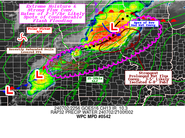
SUMMARY...Upstream development across recently saturated soils in
NE KS with rates of 2-3"/hr and potential axes of training pose
likely flash flooding conditions over the later evening.
Downstream maturing squall line to continue to track
east-southeast with similar 2-3"/hr rates and localized 3-5"
totals through 03z.

DISCUSSION...GOES-E WV suite depict mid to upper level warming
across central NEB with a subtle anti-cyclonic arched cirrus
banding indicative of a subtle upper-level jet streak across SE
NEB into SW IA; both suggestive of increased digging of the polar
shortwave providing DPVA and right entrance ascent across Eastern
KS and downstream.  22z surface analysis denotes this response
with an amplifying wave lifting through central KS northeastward
and backing surface winds across NE KS.  Additionally, this has
backed the LLJ just a bit with 30-35kts of increasing confluent
flow across the Lower Missouri Valley.  Deep moisture pooling has
increased total PWat values into the 2.25" range and the
combination of factors has seen recent convective initiation
across NE KS (and a bowing line across south-central KS). Expect
further convective development/expansion along the frontal zone
with some back-building of the upwind portion of the squall line
across N MO.  This will provide an area of favorable deep layer
unidirectional flow parallel to the convergence axis to support
short term training.  Given the parameters, of 2500-3000 J/kg
across N MO and adj. KS; rates of 2-3"/hr are probable and with
training streaks of 3-5" are possible before cold pools and
upstream shortwave support forward propagation generally after
01-02z.  Recent heavy rainfall over the region, has resulted in
lowered FFG values of 1-1.5"/hr and below 2.5"/3hr which are
likely to be exceeded resulting in broad axes of flash flooding
conditions perhaps in and around the Kansas City Metro area
(though more probable to the north and east given current trends).


Further east into the Mississippi Valley...
Regional RADAR and visible imagery depict a mature squall line
extending from north-central MO/south-central IA starting to march
into E IA and far SW WI.  The warm front has surged northward
along the southern edge of the eroding clouds in S WI. However, a
pre-frontal surface wave developed downstream of the southern
stream shortwave across central IA, but that wave is starting to
accelerate northeastward and height-falls is starting to bow the
QLCS out across SE IA.  This will intersect and become more
parallel to the 925-850mb moisture flux convergence channel and
with upstream warm advection/backing influence from approaching
polar shortwave; better moisture flux convergence will exist from
the nose of the bowing segment in SE IA/N IL back southwest into
northern MO.  As noted, higher instability into the 3000 J/kg
range, total Pwat to 2.25-2.4" and 25-30kts of inflow should
support highly efficient rainfall production with 3"/hr rates
likely.  Training will become a bit less likely given strength of
southeasterly propagation, but spots of 3-5" are likely across NE
MO/SE IA/far NW IL.  Recent WoFS solutions continue to shift this
bulls-eye south and east with each run, but there is a consistency
of of the mean values in this range, though 90th percentile values
are in the 7-8" maximum ranges at the nose of pressing bow with
spots of 4-5" across northern MO.  This is further south of the
12z/18z Hi-res guidance, but given the trends, there is increasing
confidence that portions of this area will see considerable
rainfall totals and flash flooding conditions, even though soils
have been drier they are still at 40-55% of capacity through 40cm.


Gallina

ATTN...WFO...DMX...DVN...EAX...ICT...ILX...LOT...LSX...TOP...

ATTN...RFC...ABRFC...MBRFC...NCRFC...NWC...

LAT...LON   42389008 42368897 41868852 40848891 39479109
            38549368 38109619 38829697 39639600 40029499
            40509344 41169201
Download in GIS format: Shapefile
| KML
Last Updated: 702 PM EDT Tue Jul 02 2024
|


