| WPC Met Watch |
|
|
Mesoscale Precipitation Discussion: #0540 |
|
(Issued at 209 PM EDT Tue Jul 02 2024
) |
|
| MPD Selection |
|
|
|
|
|

Mesoscale Precipitation Discussion 0540
NWS Weather Prediction Center College Park MD
209 PM EDT Tue Jul 02 2024

Areas affected...Eastern Arizona...Western New Mexico...

Concerning...Heavy rainfall...Flash flooding likely

Valid 021810Z - 030000Z

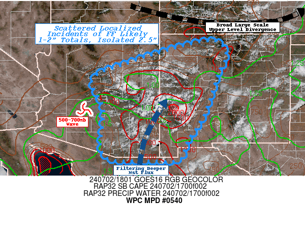
SUMMARY...Slow moving monsoon thunderstorms.  Spots of 1-2" over
areas with well above normal rainfall over last few weeks, will
pose scattered but localized flash flooding incidents.

DISCUSSION...A broad longwave trough continues to slide through
the central Rockies of WY/CO resulting in gap in return flow
across NW Mexico into the Southwest, generally centered along the
AZ/NM border before angling northeast across north-central NM.
The leaves much of NE AZ, N NM within favorable right entrance
divergence outflow channel.  CIRA LPW also notes a wave of 700-500
over the Sun Valley lifting northeast highlighted by enhanced
moisture along downstream confluence streamlines with eastern
deformation zone across the SE San Francisco Plateau, while deeper
850-500 moisture lifts north out of central Sonora into SE AZ and
across the Mogollon, Black, Gallo and Gallina Mtns.  While deep
layer moisture totals generally overlap through this axis the
range is a tad lower than the last few days with 1-1.25" total
PWats, still more will filter through the terrain with some 1.5"
values expected across Cochise county coming out of the Sea of
Cortez.  Full sun has allowed for solid instability to build with
localized pockets of SBCAPEs start to reach 2000-2500 J/kg where
valley Tds are in the low 60s in SE AZ/SW NM, though average
values of 1500 J/kg even up into the Plateau should feed stronger
thunderstorms later into the afternoon.

Initial convection appears to be developing along favored upslope
ridge lines across the deep moisture axis.  Initial thunderstorms
are likely to support .25-.5"/hr rates as the mid-levels fully
saturate.  However, deep layer steering is very weak at the
periphery of that outflow channel to the north; this supports
effective bulk shear of 20-25kts across the central border of
AZ/NM, so there may be slightly better organization to support
multiple up/down draft cycles.  Deep layer steering is weak at
5-10kts with south-southeast propagation at 0-5kts, so slow
motions should allow for increased duration.  As the afternoon
goes, the stronger heating and therefore updrafts that are spurred
on by outflow boundary collisions by the first few rounds may
support rates of 1-1.5"/hr and spots of 1-2" totals.  Coverage
should be scattered to numerous in nature today, though equal
areas are likely to miss out given the expected small to middle
size updraft widths.

NASA SPoRT 0-40cm soil saturation ratios are in the 90th
percentile plus across the area of concern. However, areas of
Catron, W Sacorro, central Cibola and S Apache county have seen
well above average moisture as soil saturation values are well
above that percentile with ratios over 55% and spots of 75-80%
suggesting limited further infiltration in areas of deeper soil,
but also rain should fall on barren rock areas as well, so give
this, there will likely be multiple incidents of flash flooding
though highly localized in nature through 00z.

Gallina

ATTN...WFO...ABQ...EPZ...FGZ...PSR...TWC...

ATTN...RFC...CBRFC...WGRFC...NWC...

LAT...LON   36670690 36110600 35160640 34130671 33100711
            32010782 31240815 31200955 31261131 31851174
            33551160 34901213 35571074
Download in GIS format: Shapefile
| KML
Last Updated: 209 PM EDT Tue Jul 02 2024
|


