| WPC Met Watch |
|
|
Mesoscale Precipitation Discussion: #0484 (2020) |
|
(Issued at 1013 AM EDT Tue Jul 14 2020
) |
|
| MPD Selection |
|
|
|
|
|

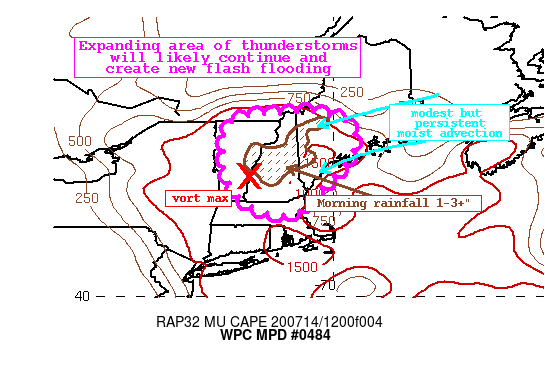
Mesoscale Precipitation Discussion 0484
NWS Weather Prediction Center College Park MD
1013 AM EDT Tue Jul 14 2020

Areas affected...Central New England

Concerning...Heavy rainfall...Flash flooding likely

Valid 141412Z - 142000Z

Summary...Showers and thunderstorms ongoing this morning will
expand in coverage through the afternoon. Rainfall rates of
1-2"/hr or more are likely, and total rainfall of 1-2" with
locally higher amounts is expected. Ongoing flash flooding may
become enhanced, and new flash flooding is likely.

Discussion...Mid-level vort max and associated trough is evident
on GOES-E IR and visible imagery this morning moving across VT/NH.
Rainfall beneath this feature has been prolific, with several
reports of 1-2" in 1 hour and 3-4" in 3 hours. This is estimated
by FLASH to exceed the 200-yr RI, and is more than double the 3-hr
FFG leading to the multiple flash flood warnings ongoing in
central/northern New England. As this feature shifts slowly
eastward into the afternoon, convective coverage is expected to
expand, and slow moving storms will persist the flash flood threat.

PWs on morning U/A soundings ranged from as low as 1.08" at CHH,
to 1.39" at GYX. At GYX this is around the 75th percentile, and
warm cloud depths were near 11,000 ft. Although morning
instability was limited by cloud cover, RAP was analyzing some
MUCape pockets of 500-1000 J/kg, just enough to help drive the
heavy rainfall. As the afternoon progresses, modest moist
advection is expected from the east into ME/NH, but more
significantly destabilization will drive CAPE values towards 2000
J/kg. This increasingly favorable thermodynamic environment will
be acted upon by the vort max and any differential heating
boundaries, with modest height falls steepening the LR's to drive
further ascent. CAMs indicate that while the core of the heavy
rainfall may not be as widespread or significant as what is
occurring this morning, the coverage of convection is likely to
expand.

Rainfall this morning has already been observed at more than 3" in
a few locations, and this is on top of areas that have 14-day
rainfall departures as high as 300% of normal leading to fully
saturated soils. Rainfall rates as estimated by HREF neighborhood
probabilities could exceed 2"/hr this aftn, and feature high
chances for more than 3"/3hrs across parts of the area. While it
may be challenging for the worked-over areas to re-destabilize
until this evening, thunderstorms will likely develop both east
and west of the current activity, potentially along differential
heating boundaries, and this is represented well by the recent
HRRR and HRRRe. It is in these regions where the heaviest rain may
fall the next 6 hours, but any additional thunderstorms that move
into the already saturated soils from this morning would also
likely pose a flash flood risk.

Forecast storm motions will remain very weak through the aftn as
noted by RAP 0-6km mean winds of just around 5 kts, so any slow
moving thunderstorm with these excessive rain rates could quickly
produce 1-2" of rainfall, with isolated amounts to 4" possible.
This would be most likely where any boundary interactions can take
place either from outflows/mergers or with the sea breeze where
some backbuilding is possible along the southern coast of Maine.
This is likely to create areas of flash flooding into this
evening.

Weiss

ATTN...WFO...ALY...BOX...BTV...GYX...

ATTN...RFC...NERFC...NWC...

LAT...LON   45287083 45267040 45157002 45036969 44846945
            44576937 44276938 44176946 43916954 43676981
            43377006 43107039 42787068 42517087 42407119
            42367151 42467194 42637240 42857267 43207292
            43697311 44057313 44407308 44727309 44977293
            45127249 45207207 45247130
Last Updated: 1013 AM EDT Tue Jul 14 2020
|


