| WPC Met Watch |
|
|
Mesoscale Precipitation Discussion: #0343 (2021) |
|
(Issued at 902 PM EDT Mon Jun 14 2021
) |
|
| MPD Selection |
|
|
|
|
|

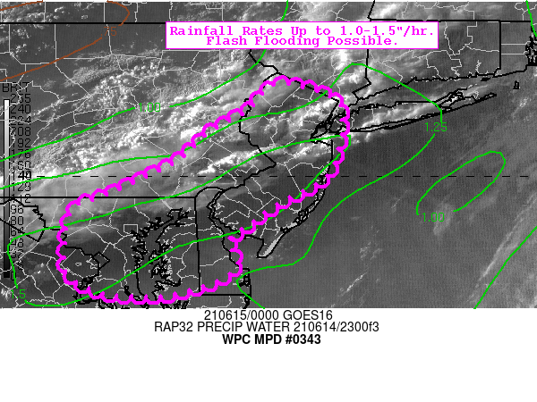
Mesoscale Precipitation Discussion 0343
NWS Weather Prediction Center College Park MD
902 PM EDT Mon Jun 14 2021

Areas affected...New Jersey...Delaware...Southeastern
Pennsylvania..Northern Maryland...Greater DC Area

Concerning...Heavy rainfall...Flash flooding possible

Valid 150100Z - 150600Z

Summary...Rainfall rates up to 1.0-1.5"/hr may cause isolated
instances of flash flooding, mainly in urbanized areas.

Discussion...A progressive shortwave trough and an associated cold
front are sweeping eastward this evening towards the Mid-Atlantic
region. Showers and thunderstorms are increasing in coverage ahead
of and along the front, with the strongest activity already
producing rainfall rates up to 1.0-1.5"/hr. The mesoscale
environment is characterized by wide-ranging SBCAPE of 1000-2500
J/kg, PWATs of 1.25-1.50 inches, and effective bulk shear of 40-50
kts. While convection overall is fairly progressive (and quickly
organizing linearly), some initiation ahead of the front (and main
developing squall line) has acted to pre-saturate some urbanized
areas. This may allow storm totals (over a 3-hr period) to
approach (or perhaps exceed) 2 inches locally through 06z.

Flash Flood Guidance (FFG) across the majority of the highlighted
region will likely not be exceeded, but where ideal training of
convection occurs (coincident with urbanized terrain) isolated
exceedance is possible. This threat is best expressed by 40km
neighborhood probabilities via the 12z HREF suite, suggesting a
10% exceedance probability of 2.0" over a 1-hr period (and 10-20%
over a 3-hr period). Recent runs of the HRRR paint a similar
picture, with the deterministic QPF output showing 1.5-2.0 inches
locally. Should these totals occur over a vulnerable metro area,
isolated flash flooding is possible.

Churchill

ATTN...WFO...AKQ...CTP...LWX...OKX...PHI...

ATTN...RFC...MARFC...NERFC...NWC...

LAT...LON   41177478 41177443 41077409 40957388 40737386
            40517387 40317392 40007406 39777442 39657469
            39467493 39157534 38887521 38647547 38457608
            38437653 38457690 38577725 38757747 39027748
            39397744 39627731 39737697 39977645 40207598
            40597556 40837510
Last Updated: 902 PM EDT Mon Jun 14 2021
|


