| WPC Met Watch |
|
|
Mesoscale Precipitation Discussion: #0334 (2019) |
|
(Issued at 1224 PM EDT Wed May 29 2019
) |
|
| MPD Selection |
|
|
|
|
|

Mesoscale Precipitation Discussion 0334...Corrected
NWS Weather Prediction Center College Park MD
1224 PM EDT Wed May 29 2019

Corrected for Probability of Flash Flooding to Likely

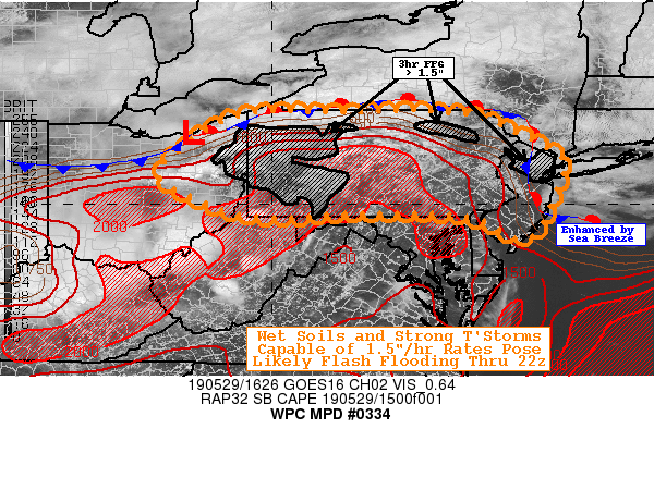
Areas affected...Pennsylvania...New Jersey...NYC Metro...Eastern
Ohio...Stovepipe of WV...

Concerning...Heavy rainfall...Flash flooding likely

Valid 291615Z - 292200Z

SUMMARY...Unstable, moist, and unidirectional flow environment
supportive of repeat convection across wet ground conditions for
possible flash flooding this afternoon...

DISCUSSION...GOES-16 satellite imagery depicts a sheared shortwave
crossing southeast Michigan into Lake Erie at the leading edge of
deeper mid-level moisture, with 7H RHs increasing to 70-90% just
ahead/behind the attendant trof angling back across central OH at
this time.  Surface analysis and GOES-16 Visible imagery depict a
warm front extending near the S/W (weak surface low in Northern
Ohio) along/just north of the PA/NY before angling through S NY
toward the NYC metro area.  A strong sea-breeze was also noted
crossing northern NJ, potentially focusing convection earlier as
well as enhancing for additional convection later this afternoon.
 Given proximity to the lower FFG of this urban corridor, felt
incorporating this area into the MPD well before main forcing
approaches later this evening.  South of the boundary, very moist
low level environment exists with Tds in the mid to upper 60s with
spot 70F values.  12z PIT sounding denotes the weak mid-level
drying at 7H as well as above 5H, supporting total PWs around
1.3", though upstream is about 1.5-1.6" per GPS/BLTPW imagery
across Central OH.  Given this profile, thunderstorms today should
be fairly efficient rainfall producers with hourly rates in the
1-1.5"/hr range.   Currently, cu, area becoming agitated near Lake
Erie and Northwest PA with a few additional cells across
east-central Ohio starting to TCU into CBs.

The mean steering flow is very strong today, likely limiting
duration of one given cell. Though given upstream energy into
overall confluent flow over the Northeast US, flow will be
continue to become unidirectional through much of the steering
environment, and with inflow strong upstream, the potential for
backbuilding or repeating convection is solid today and allow for
2-3hr totals to reach 2-3" in spots, perhaps higher to 4"+ if one
or two bands E-W of convection develop, per HRRR, 12z ARW
solutions.  More likely without a strongly capped environment
convection, like yesterday, should be numerous in nature from
north to south to reduce the most extreme training threat.
Still, given the broad area of heavy rainfall (particularly north
and east of I-80 in OH, I-76 in PA), grounds are very wet with the
bulk of northeast Ohio, Central PA into NJ running about 75-90%
saturated per the National Water Model through 40cm with
rivers/tributaries running above normal.

So this additional rainfall in short-duration and repeating nature
suggests flash flooding is likely through much of the area through
the 22z this evening, given moisture, instability and antecedent
conditions (FFG below 1"/1hr 1.5"/3hrs in W PA, northeast PA).

Gallina

ATTN...WFO...BGM...CLE...CTP...OKX...PBZ...PHI...

ATTN...RFC...MARFC...NERFC...OHRFC...

LAT...LON   41997683 41827547 41487472 40947375 40387387
            39557421 39247467 39637548 39797651 39797840
            39767935 39848020 39878108 40168173 40498239
            40838234 41218185 41558145 41828087 41988004
            41947867
Last Updated: 1224 PM EDT Wed May 29 2019
|


