| WPC Met Watch |
|
|
Mesoscale Precipitation Discussion: #0311 (2022) |
|
(Issued at 307 PM EDT Tue Jun 07 2022
) |
|
| MPD Selection |
|
|
|
|
|

Mesoscale Precipitation Discussion 0311
NWS Weather Prediction Center College Park MD
307 PM EDT Tue Jun 07 2022

Areas affected...Lower Mississippi Valley

Concerning...Heavy rainfall...Flash flooding possible

Valid 071900Z - 080000Z

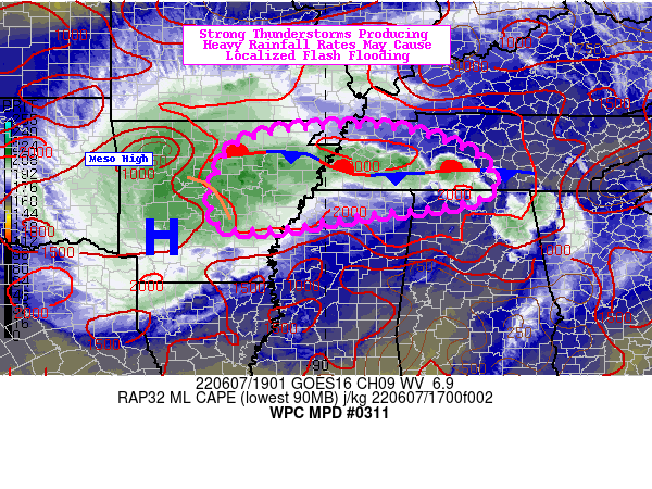
SUMMARY...Convection firing along a frontal boundary may produce
areas of flash flooding in more flood prone or low lying area.
Approaching MCV to also play a role in potential flash flooding
this afternoon.

DISCUSSION...Two identifiable features are responsible for
potential flash flooding in parts of the Lower Mississippi Valley
this afternoon. The first is an MCV tracking through northern
Arkansas that is being driven by an organized cold pool positioned
over western Arkansas. 18Z surface analysis did pick up on a meso
high located within the cold pool that was initially being
supported by sufficient effective bulk shear over Oklahoma and
western Arkansas. It is leaving the best area of vertical wind
shear, which will leave this complex susceptible to weakening in
the coming hours. However, the cold pool should be able to keep
the complex in tact for a couple more hours as it approaches the
Mississippi River and potentially into northern Mississippi. It
has remained progressive, but its associated convection will
eventually track into Tennessee, where a lingering frontal
boundary is acting as a trigger for its own clusters of convection.

Speaking of the front, PWs along the front are up to 2.0", which
is at or above the 90th climatological percentile from eastern
Arkansas to central Tennessee. Mesoanalysis does depict a highly
unstable atmosphere present with 2,000-3,000 J/kg of CAPE at the
front's disposal. The cloud layer (LCL-EL) mean flow according to
HRRR area averaged soundings around 21Z is 256/20, suggesting that
while storm motions are a little progressive, the mean flow is
quasi-parallel to the front, giving rise to the potential for
training. There is also the opportunity for the northern flank of
the ongoing MCV to track towards portions of eastern AR, southwest
TN, and northern MS.

12Z HREF did indicate parts of the region containing >25%
probabilities of 3-hr QPF exceeding 3-hr FFG. Even 1-hr FFGs are
as low as 1.5", which given the available instability and
potential for training convection, could be surpassed in spots.
The areas most at risk for flash flooding is likely to be along
the front both from the convection currently firing along it, and
any residual convection on the MCVs northern flank that is set to
track close to the Memphis metro in the next hour or two. Low
lying spots and urbanized areas with more hydrophobic surfaces are
also more favored to witness flash flooding.

Mullinax

ATTN...WFO...HUN...LZK...MEG...OHX...

ATTN...RFC...ABRFC...LMRFC...OHRFC...SERFC...NWC...

LAT...LON   36358989 36268825 35688670 34888664 34488927
            34209118 34359236 35729216 36229120
Last Updated: 307 PM EDT Tue Jun 07 2022
|


