| WPC Met Watch |
|
|
Mesoscale Precipitation Discussion: #0295 (2022) |
|
(Issued at 722 AM EDT Sat Jun 04 2022
) |
|
| MPD Selection |
|
|
|
|
|

Mesoscale Precipitation Discussion 0295
NWS Weather Prediction Center College Park MD
722 AM EDT Sat Jun 04 2022

Areas affected...South Florida...2

Concerning...Heavy rainfall...Flash flooding likely

Valid 041130Z - 041730Z

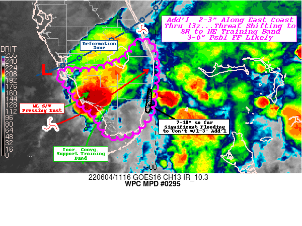
SUMMARY...PTC One's East Coast to move away with lingering
rainfall maintaining flooding conditions, while a new band of
training convection from SW to NE expected to form as wave crosses
southern FL.

DISCUSSION...Surface, RADAR and 3.9um depict an inflection along
the low level deformation zone just west of Sanibel Island
extending across the peninsula to a secondary twist near Stuart
that does not appear to have mixed to the surface quite yet but is
hinted at in short-term forecast guidance.  This is in response to
the mid-level shortwave, currently SW of Marco Island to start
east-northeastward translation in the next few hours.

Currently, strong surface convergence along the East Coast with
solid fairly unidirectional southerly narrow skinny CAPE
moist/unstable environment providing continuing convection along
the SE Urban corridor from Miami to West Palm Beach.  Additional
2-3" across this area is expected in the next 1-2 hours before
slowly shifting offshore.  This should bring some isolated totals
over 10" and possible toward 12" in N Miami, expanding to 6-8"
into E Broward and 2-4" into Palm Beach county.  The band will
shift east, but given the developing inflection near Stuart, this
may reduce eastward propagation there allowing for slightly
increased duration even if rates may be a bit reduced further from
unobstructed instability source much further south.

While the N-S oriented band is pressing off shore, the surface
wave near Sanibel combined with veering mid-level flow is starting
to increase deep layer confluence oriented from SW to NE across
Southern Florida, there is some uncertainty to the latitude of
this orientation as forcing/confluence is stronger northeast near
the deformation zone/surface wave inflection(s) but instability
over the Southeast Gulf and favorable frictional
convergence/confluence of surface flow south of Marco Island,
suggests best convergence may support the band to train a bit
further south across NW Monroe county toward W & N Broward/S Palm
Beach county. ARW solutions suggest even further across southern
peninsular Monroe county toward Miami-Dade, which is not out of
the realm of possibility.

Ample deep moisture and instability should allow for 2-3"/hr rates
and suggest an additional 3-6" is possible associated with this
band, particularly upstream with backbuilding over the next
3-6hrs.  As such, continued rapid inundation/flash flooding is
likely to continue.

Gallina

ATTN...WFO...MFL...MLB...TBW...

ATTN...RFC...SERFC...NWC...

LAT...LON   27328021 27118006 26657998 26048004 25608012
            25508021 25288039 25178059 25118106 25678143
            25868175 26078183 26258198 26538224 26618207
            26628141 26928067 27228048
Last Updated: 722 AM EDT Sat Jun 04 2022
|


