| WPC Met Watch |
|
|
Mesoscale Precipitation Discussion: #0285 (2019) |
|
(Issued at 254 PM EDT Fri May 24 2019
) |
|
| MPD Selection |
|
|
|
|
|

Mesoscale Precipitation Discussion 0285
NWS Weather Prediction Center College Park MD
254 PM EDT Fri May 24 2019

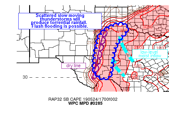
Areas affected...West Texas into the Panhandle

Concerning...Heavy rainfall...Flash flooding possible

Valid 241853Z - 250053Z

Summary...Scattered slow moving strong thunderstorms capable of
producing excessive rainfall will drift eastward this afternoon.
Although storm coverage may remain scattered, any individual cell
will have the potential to produce flash flooding.

Discussion...Tremendous instability of more than 4000 J/kg SBCape
is fueling convective development ahead of a dry line across West
Texas. Low level ascent due to convergence along the dry line will
be aided by subtle height falls and upper diffluence to force
convection through the afternoon. These storms may remain discrete
due to bulk shear of 25-40 kts and this is represented well by
recent runs of the HRRR, suggesting the flash flooding threat may
remain isolated to scattered and focused beneath the individual
discrete thunderstorms. However, each of these cells are likely to
move slowly eastward in response to short Corfidi vectors as the
850mb wind begins to back more to the southeast while the mean
layer wind remains from the southwest. PWATs of 1.25 inches will
fuel the heavy rainfall, and rates of more than 1.5"/hr are likely.

Despite the potential for only scattered thunderstorms across the
risk area, increasing moist inflow on the intensifying LLJ will
enhance the heavy rain risk as the afternoon progresses. Recent
rainfall across West Texas has been extreme in some of the areas
that may receive heavy rainfall again this afternoon, noted by
7-day departures from normal of 200%-300%. Soil moistures are
saturated in a few areas, further suggesting that rainfall should
quickly become runoff which turns into flash flooding. A few areas
which experience these slow moving thunderstorms may receive
upwards of 3" of rainfall, which would likely exceed the 3-hr FFG
and produce flash flooding.

Weiss

ATTN...WFO...AMA...EWX...LUB...MAF...SJT...

ATTN...RFC...ABRFC...WGRFC...

LAT...LON   34890041 34820018 34730013 34540012 34150026
            33760068 33280101 32760121 32300137 31690146
            31320150 31010154 30280163 30030187 29970223
            30050250 30220275 30550301 30830307 32150296
            32260297 32420291 33130276 33440274 33770257
            34020241 34280218 34420198 34560169 34670152
            34770123 34850094 34880070
Last Updated: 254 PM EDT Fri May 24 2019
|


