| WPC Met Watch |
|
|
Mesoscale Precipitation Discussion: #0265 (2019) |
|
(Issued at 728 PM EDT Mon May 20 2019
) |
|
| MPD Selection |
|
|
|
|
|

Mesoscale Precipitation Discussion 0265
NWS Weather Prediction Center College Park MD
728 PM EDT Mon May 20 2019

Areas affected...Oklahoma, Southeast Kansas, Far Southwest
Missouri

Concerning...Heavy rainfall...Flash flooding likely

Valid 202327Z - 210515Z

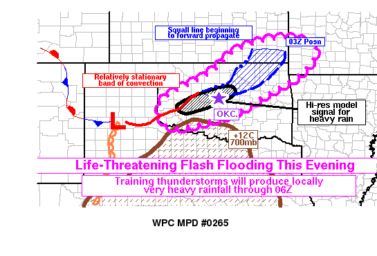
Summary...The threat of flash flooding will continue to increase
this evening across the southern Plains. Repeated rounds of
thunderstorms are likely to cause locally very heavy rainfall,
especially across central Oklahoma. The areas that receive the
heaviest rainfall could see severe, life-threatening flash
flooding, especially if it occurs over an urban area.

Discussion...At 23Z, a broken line of convection extended from SE
KS into W OK, from K13K to KSWO to KCSM to KCDS. Two important
trends were beginning to occur. First, the northern segment of the
line was increasingly forward propagating, with the Oklahoma
Mesonet site at Newkirk showing a surface pressure about 5mb
higher than the background field. Temperatures were in the mid-50s
behind the squall line and KTLX radar was showing the outflow
boundary making progress south in C OK closer to the I-40
corridor. The second key trend was a relatively stationary
position of the band of convection further upstream in W OK and
the far E TX Panhandle. Although this has shifted somewhat further
south over the past few hours, it was not propagating as much as
the northern half of the line of convection.

The 20Z and 21Z HRRR and 22Z Warn-on Forecast System were doing a
reasonably good job of representing ongoing trends, and showed the
northern line segment pushing through the remainder of SE KS and
much of NE OK by 03Z. This seems reasonable with the increasingly
well-established near-surface cold pool. Heavy instantaneous rain
rates are likely with these storms, and rain rates could reach as
high as 2 in/hr. KPNC measured 1.81 inches of rain in an hour from
22-23Z. However, the progressive nature of the storms may smear
the rainfall out over a broader area and limit the overall
duration of heavy rain at any one location in SE KS and NE OK.
Nevertheless, flash-flood guidance is lower in these areas so
sporadic instances of flash flooding still appear possible this
evening, perhaps extending as far northeast as SW MO where
elevated instability does exist.

As thunderstorm outflow arcs out to the southeast in the eastern
half of Oklahoma, the composite outflow boundary and surface warm
front should become oriented more in a west-east direction and
closer to parallel with the Corfidi propagation vectors along and
near the boundary. With unobstructed southerly inflow, and the
boundary located on the nose of a strong low-level jet, organized
training convection may last well into the evening and repeatedly
affect some concentrated areas. The HRRR and WoFS focus the
heaviest QPF through 06Z from near Hobart to near the Oklahoma
City metro area. This is consistent with an outflow boundary
pushing south to near I-40 in the OKC metro area at the moment and
plenty of upstream convection that is likely to move into the
aforementioned area over the next few hours. Furthermore, the
southward extent of convection in W OK may be limited by a
mid-level cap, with 700mb temperatures in excess of +12C nosing
into SW/SC OK. Therefore, the cap (on the south) and the outflow
boundary (on the north) may act to funnel convection into an
increasingly concentrated area on a boundary with strong low-level
convergence. This should only increase the heavy rainfall threat
with time. Rain rates with the strongest thunderstorm clusters
could exceed 2 in/hr and severe, life-threatening flash flooding
could develop in areas that see a few hours of training.

Lamers

ATTN...WFO...ICT...OUN...SGF...TSA...

ATTN...RFC...ABRFC...MBRFC...

LAT...LON   38009479 37599348 36599408 35679559 34989679
            34539813 34379952 35319992 35989893 36569780
            37569663
Last Updated: 728 PM EDT Mon May 20 2019
|


