| WPC Met Watch |
|
|
Mesoscale Precipitation Discussion: #0249 (2019) |
|
(Issued at 940 PM EDT Fri May 17 2019
) |
|
| MPD Selection |
|
|
|
|
|

Mesoscale Precipitation Discussion 0249
NWS Weather Prediction Center College Park MD
940 PM EDT Fri May 17 2019

Areas affected...West central TX

Concerning...Heavy rainfall...Flash flooding possible

Valid 180145Z - 180730Z

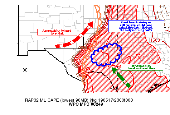
Summary...Short training or cell mergers across portions of west
central TX could result in a flash flood threat into the early
morning hours.

Discussion...The GOES-16 clean IR loop showed an expanding area of
cold cloud tops across portions west central TX, though the tops
have warmed in recent images. The convection developed on the
dryline, which provided sufficient low level convergence to allow
the storms to punch through the mid level cap late this afternoon.
The airmass is still relatively dry across this part of TX, as the
00z MAF sounding showed precipitable water values near an inch.

The soundings also showed mid level lapse rates greater than 7.5
C/km, and not surprisingly, the storms have been hail/wind driven
thus far. The sounding also showed that the cap has been broken
here (though it remains in place across north TX, per the 00z FWD
sounding). More storms are developing near the dryline, and along
old outflow boundaries laid down by the first cluster of storms.

As a developing 90 knot jet streak crosses NM into the TX
Panhandle before 18/06z, increasing difluence should allow
synoptic scale lift to help remove some of the remaining cap, and
organize convection forming in the axis of 1500/3000 J/KG of
MLCAPE across west TX. Ahead of the jet streak and attendant short
wave, a 30/40 knot low level southeast flow transports 1.50 inch
precipitable water air into west and central TX, and the
increasing moisture should be ingested into the developing
convection.

The increased moisture could allow the cells to transition from
mainly hail and wind to more of a flash flood threat, especially
where short term training and cell mergers occur (as the
propagation vectors suggest supercells mergers as the entire area
of convection moves northeast with the mid level flow).

There is a multi high resolution model signature for local
2.00/4.00 inch rainfall amounts across portions of central TX,
with the most recent HRRR indicating a bullseye between Midland
and San Angelo. Three hour flash flood guidance values are as low
as 2.50 inches, as some areas have seen over 250 percent of normal
rainfall over the past 14 days. Based on the above, there is a
flash flood threat, especially where short term training or cell
mergers occur. The threat could persist beyond 18/07z.

Hayes

ATTN...WFO...MAF...SJT...

ATTN...RFC...WGRFC...

LAT...LON   32270032 31869977 31090007 30610110 30650174
            31040228 31600192
Last Updated: 940 PM EDT Fri May 17 2019
|


