| WPC Met Watch |
|
|
Mesoscale Precipitation Discussion: #0176 |
|
(Issued at 1127 AM EDT Fri Apr 26 2024
) |
|
| MPD Selection |
|
|
|
|
|

Mesoscale Precipitation Discussion 0176
NWS Weather Prediction Center College Park MD
1127 AM EDT Fri Apr 26 2024

Areas affected...eastern OK into northwestern AR and southwestern
MO

Concerning...Heavy rainfall...Flash flooding possible

Valid 261526Z - 262040Z

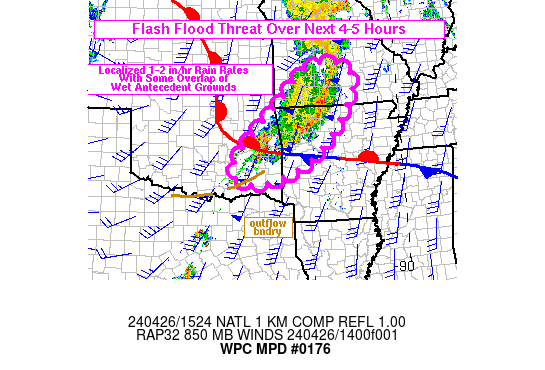
SUMMARY...Localized areas of training may support additional heavy
rainfall rates with 1-2 in/hr impacting portions of eastern OK
into northwestern AR and southwestern MO through ~20Z. Given wet
antecedent conditions in portions of the region, flash flooding
will be possible.

DISCUSSION...At 15Z, convection, much of it elevated, continued to
stretch from eastern OK into northwestern AR and southwestern MO,
with the northern portion showing more progressive movement toward
the east than the portion farther south into OK. The thunderstorms
were located along and north of a warm/stationary front that
extended eastward through eastern OK into central AR where the 15Z
SPC mesoanalysis indicated 500-1000 J/kg MUCAPE in place. Farther
south, breaks in cloud cover were beginning to appear on visible
satellite imagery, which should allow for surface heating and a
weakening of MLCIN across locations south of the warm/stationary
front. Also of note, an outflow boundary was located at the
leading edge of the rain shield moving through AR into
southeastern OK, with low level southerly flow overrunning the
boundary, but better isentropic ascent was occurring farther
north, ahead of the warm/stationary front. Coupled with the low
level ascent was a a notable region of upper level diffluence
centered over southwestern MO along with smaller scale regions of
jet-influenced upper level divergence.

With deeper-layer winds oriented from the southwest, or roughly
parallel to the slower moving leading edge of precipitation,
additional convective development along the southwestern flank is
likely to train...at least temporarily...allowing for 1-2 in/hr
rates and an additional 2-4 inches through ~20Z. Precipitable
water values near 1.5 inches and sufficient instability will allow
the flash flood threat to linger across the region over the next
3-5 hours. Adding to the threat, especially for locations in
southwestern MO, is wet antecedent soils where an estimated 2 to 6
inches of rain has fallen over the past 24 hours. Flash flooding
will remain possible for these locations through at least 20Z.

Otto

ATTN...WFO...LZK...OUN...SGF...SHV...TSA...

ATTN...RFC...ABRFC...LMRFC...MBRFC...NWC...

LAT...LON   37759226 37409169 36769177 35849240 34809352
            34229509 34359606 34829616 35489567 36449463
            37649331
Download in GIS format: Shapefile
| KML
Last Updated: 1127 AM EDT Fri Apr 26 2024
|


