| WPC Met Watch |
|
|
Mesoscale Precipitation Discussion: #0174 |
|
(Issued at 541 AM EDT Fri Apr 26 2024
) |
|
| MPD Selection |
|
|
|
|
|

Mesoscale Precipitation Discussion 0174
NWS Weather Prediction Center College Park MD
541 AM EDT Fri Apr 26 2024

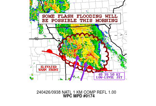
Areas affected...Portions of Western and Central MO

Concerning...Heavy rainfall...Flash flooding possible

Valid 260940Z - 261400Z

SUMMARY...Persistent areas of heavy showers and thunderstorms
going through mid-morning may result in some areas of flash
flooding.

DISCUSSION...Strong warm air advection and corresponding
isentropic ascent will continue to favor an axis of heavy showers
and thunderstorms this morning across areas of western and central
MO.

This will be strongly facilitated by the persistence of a 40 to 50
kt southwest low-level jet which is also helping to drive a
well-defined pool of elevated instability and corridor of moisture
transport. MUCAPE values are generally on the order of 1000 to
1500 J/kg, but much of northwest to central MO has seen a rather
strong uptick in elevated instability over the last few hours,
with 3-hour CAPE differentials of +500 to +1000 J/kg. This is also
collocated with an 850 mb warm front and corresponding focus for
stronger forcing.

Over the next few hours going through mid-morning, additional
repeating areas of heavy showers and thunderstorms are expected as
this elevated front and axis of instability remains focused over
the region. Given the stronger moisture transport, the rainfall
rates should remain heavy with some 1.5"/hour rainfall rates
possible with the stronger storms.

Additional rainfall amounts of as much as 2 to 3 inches will be
possible, and given some of the heavy rainfall that has already
occurred over the last few hours, some areas of flash flooding
will be possible.

Orrison

ATTN...WFO...EAX...LSX...SGF...

ATTN...RFC...MBRFC...NCRFC...NWC...

LAT...LON   40069299 39619208 38839179 38249235 38349342
            38859460 39369487 39679478 40029417
Download in GIS format: Shapefile
| KML
Last Updated: 541 AM EDT Fri Apr 26 2024
|


