| WPC Met Watch |
|
|
Mesoscale Precipitation Discussion: #0141 |
|
(Issued at 453 PM EDT Tue Apr 09 2024
) |
|
| MPD Selection |
|
|
|
|
|

Mesoscale Precipitation Discussion 0141
NWS Weather Prediction Center College Park MD
453 PM EDT Tue Apr 09 2024

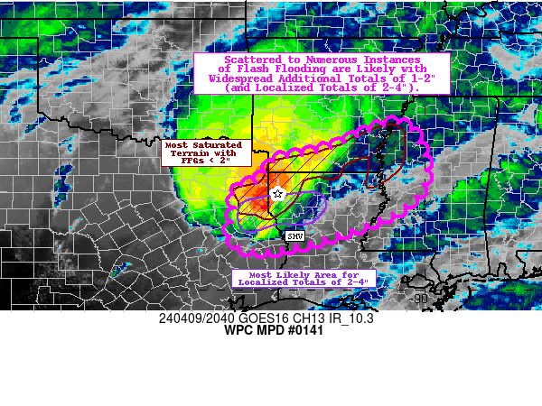
Areas affected...Ark-La-Tex into northern LA, southern AR, and
west-central MS

Concerning...Heavy rainfall...Flash flooding likely

Valid 092115Z - 100315Z

Summary...Scattered to numerous instances of flash flooding likely
with widespread additional totals of 1-2" (and localized totals of
2-4"). Some significant flash flooding is possible.

Discussion...An MCS has gained better organization across portions
of eastern TX over the past several hours, producing hourly
rainfall totals of 1-2" in association with the primary bow echo
(per MRMS estimates). The mesoscale environment looks to remain
favorable for maintaining the MCS, as a strong (but slowly waning)
LLJ transports ample moisture northward from the Gulf the a
shortwave trough aloft providing 50-70 kts of deep layer shear.
The primary bow echo looks to continue to progress towards the ENE
at 40-50 kts, nearly parallel with an associated quasi-stationary
surface front (as well as the 850-300 mb mean flow). Backbuilding
of convection along the southwestern flank of the MCS will
continue to allow for training of heavy rainfall rates, which may
lead to hourly totals to reach as high as 3" locally. As a result,
some localized 2-4" totals are expected along the southwestern
flank of the MCS, favoring areas near and south of Shreveport.
Should the bow echo maintain its structure as it travels generally
eastward, than these higher totals may extend as far east as
northeast LA into the west-central MS (most prominently depicted
by the ARW and HRRR solutions).

While north-central LA is the most favored corridor for intense
convection (directly along the gradient of favorable instability
with MU CAPE of 500-1500 J/kg), areas just to the north (from
northwest LA into southern AR and the MS Delta) remain the most
saturated from prior rainfall (with FFGs generally < 2"). While
the MCS should begin to favor a southeast drift (as mature MCSs
tend to migrate to the warm side of the stationary front), the
northern flank (and possibly north bookend vortex) can still
produce very heavy rainfall, resulting in localized hourly totals
of 1-2" (but generally limited to 2" due to less favorable
training). This will likely result in scattered to numerous
instances of flash flooding, given relatively widespread totals of
1-2" (and more localized totals of 3-4"). Also, given the wet
antecedent conditions across much of the region, some significant
instances of flash flooding are possible.

Churchill

ATTN...WFO...HGX...JAN...LCH...LZK...MEG...SHV...

ATTN...RFC...LMRFC...WGRFC...NWC...

LAT...LON   34309061 32988997 31989082 31049376 31259500
            32089489 32629493 32749433 32969415 33349382
            33639249
Download in GIS format: Shapefile
| KML
Last Updated: 453 PM EDT Tue Apr 09 2024
|


