| WPC Met Watch |
|
|
Mesoscale Precipitation Discussion: #0095 (2019) |
|
(Issued at 720 PM EDT Wed Mar 13 2019
) |
|
| MPD Selection |
|
|
|
|
|

Mesoscale Precipitation Discussion 0095
NWS Weather Prediction Center College Park MD
720 PM EDT Wed Mar 13 2019

Areas affected...Central/Eastern NE...Western IA

Concerning...Heavy rainfall...Flash flooding likely

Valid 132320Z - 140520Z

Summary...A new round of heavy rainfall this evening in
conjunction with rapid snowmelt is likely to result in additional
flash flooding. This will be particular a concern where ice jams
have occurred.

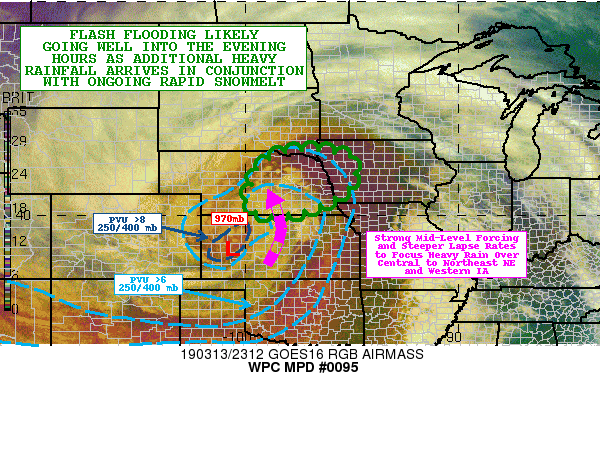
Discussion...The latest GOES-16 Airmass RGB imagery shows a very
intense deep layer cyclone ejecting off to the east out across the
central Plains. The deep reds and oranges show the advance of a
very strong PV anomaly (6 to 8+ PVUs in the 250/400mb layer) and
related dry air associated with a robust tropopause fold. This
tropopause fold is facilitating a deeply occluded surface low over
western KS with a central pressure of 970mb as of 21Z. This very
compact and deep layer cyclone will advance an axis of very strong
mid-level forcing/lift out of western KS and across areas of
central to northeast NE and western IA through the evening hours.
This coupled with steepening mid-level lapse rates should result
in an axis of heavy rainfall with some embedded thunderstorms.

The latest hires model consensus, including recent runs of the
HRRR support hourly rainfall amounts of as much as 0.30 to 0.50
inches, with additional rainfall totals through 05Z of as much as
1 to 1.5 inches with locally heavier amounts. The heaviest
rainfall amounts are expected to be over areas of central and
northeast NE as suggested by the 18Z HREF probabilistic output,
but some potential for locally heavy rain will exist over western
IA as well.

The surge of strong southerly winds and much warmer temperatures
east of the low center and up over the pre-existing snowpack has
led to rapid snowmelt today which coupled with earlier moderate to
heavy rainfall has already led to locally significant runoff and
flash flooding concerns, with a particular focus on areas where
ice jams have occurred.

The additional round of heavy rainfall this evening coupled with
continued snowmelt (where the snowpack remains intact) is expected
to exacerbate ongoing flooding and flash flooding concerns well
through the evening hours.

Orrison

ATTN...WFO...DMX...FSD...GID...LBF...OAX...

ATTN...RFC...MBRFC...NCRFC...

LAT...LON   43059701 42909575 42609493 41689493 40959562
            40349692 40009871 40459991 41099976 42169940
            42879841
Last Updated: 721 PM EDT Wed Mar 13 2019
|


