| WPC Met Watch |
|
|
Mesoscale Precipitation Discussion: #0085 (2019) |
|
(Issued at 927 PM EST Tue Mar 05 2019
) |
|
| MPD Selection |
|
|
|
|
|

Mesoscale Precipitation Discussion 0085
NWS Weather Prediction Center College Park MD
927 PM EST Tue Mar 05 2019

Areas affected...Southern California...

Concerning...Heavy rainfall...Flash flooding likely

Valid 060230Z - 060830Z

SUMMARY...Increasing deep convective nature within warm conveyor
poses increased rain rates and likely threat for flash flooding
conditions over the next few hours.

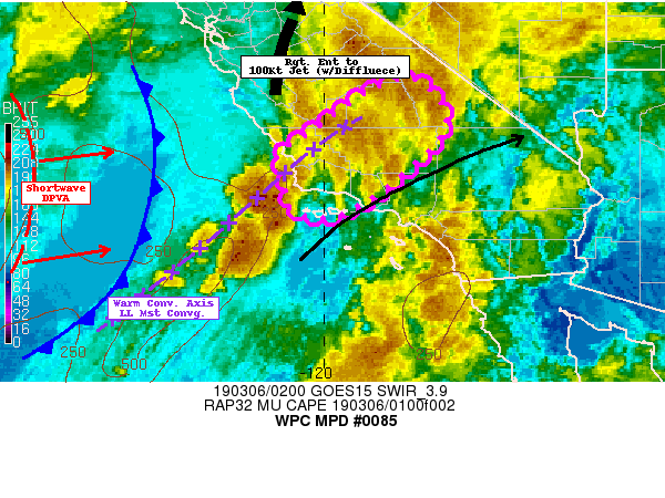
DISCUSSION...GOES-17 WV suite depicts an exiting shortwave near
the San Francisco Bay area, flattening the flow for a short-term
lull in overall coverage and intensity within the warm conveyor
belt that is directed at Point Conception and angles across the
southern San Joaquin Valley into the Greenhorn Range of the
Southern Sierra Nevada mountains.  RADAR depicts broken showers
and shield precipitation ongoing through this axis.

However, conditions are changing rapidly upstream to support an
additional round of heavy rainfall with convective elements
especially after 03z.  GOES-17 waning visible and SWIR loops
depict increasing convective coverage and depth with solid areas
of detected lightning strikes, upstream of Point Conception.
This is in dual response to advancing strong short-wave rotating
around the SW base of the trof near 130W, providing ample DPVA
along the trailing vertically stacked low level warm conveyor,
supplying steepening mid-level lapse rates with CAA aloft.  As
such MUCAPEs have sprung up to over 500-750 J/kg.  Additionally,
aloft, right entrance dynamic ascent from the exiting 3H Jet 100kt
jet over Central CA that is also fairly diffluent over S CA
provides ample large scale ascent and evacuation for strong
updrafts.

At the low levels due to the height-fall response, increased
backing flow across the California Bight has sharpened the surface
convergence band additionally providing ample moisture flux.
Total PWs of 1.3" are around 200% of normal, however, the strength
of the 25-30kt surface low level convergent flow and updraft
strength should support maximum rain rates of 1.25-1.5"/hr,
approaching the coast in the 05-06z time frame, as suggested by
the Experimental HRRR (aided by low level orographic ascent along
the Santa Inez).  The orientation, timing of the shortwave will
should also generally slow eastward progression of the warm
conveyor and focus heaviest rain over Santa Barbara into Ventura
counties over the next 4-6hrs, slowly drifting into LA county
toward 10-12z.  This is in line with ARW, Exp. HRRR and recent
HRRR guidance that has been performing best through the last few
hours.

Downstream of the intersection of the warm conveyor belt and the
coastal mountain range, will still have significant moisture flux
and orographic ascent in the Transverse Ranges and the Southern
Sierra Nevada (Greenhorn Ranges).  Totals of up to 1.5-2.5" can be
expected by 09z and possibly up to 4" by 12z especially along the
Santa Inez and Greenhorn Ranges.  As such flash flooding is
considered likely through the overnight hours, especially in the
Thomas and Hill/Woolsey burn scars.
Gallina

ATTN...WFO...HNX...LOX...VEF...

ATTN...RFC...CNRFC...

LAT...LON   36751797 35921743 35031809 34101935 33882015
            34172079 34682078 35182098 35732022 36621892
Last Updated: 927 PM EST Tue Mar 05 2019
|


