| WPC Met Watch |
|
|
Mesoscale Precipitation Discussion: #0064 (2019) |
|
(Issued at 457 PM EST Fri Feb 22 2019
) |
|
| MPD Selection |
|
|
|
|
|

Mesoscale Precipitation Discussion 0064
NWS Weather Prediction Center College Park MD
457 PM EST Fri Feb 22 2019

Areas affected...southern AR, northern LA into northern MS and far
southwest TN

Concerning...Heavy rainfall...Flash flooding possible

Valid 222153Z - 230345Z

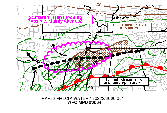
Summary...Flash flooding will be possible from northern LA,
southern AR into northern MS and far southwestern TN, mainly after
00Z. Despite low Flash Flood Guidance values present across some
of these locations, the coverage of flash flooding is expected to
be more spotty in nature compared to the more widespread coverage
observed earlier this morning.

Discussion...2130Z regional radar imagery showed a WSW to ENE
oriented axis of moderate to heavy rain with embedded
thunderstorms stretching from northeastern TX through southern AR
into northern MS. The heaviest rainfall was co-located near an 850
mb convergence axis identified via area VAD wind plots with backed
winds just north of the 850 mb axis. Local surface observations
indicated rainfall rates along and just east of the Mississippi
River have averaged less than 0.25 in/hr over the past hour or two
given little to no instability and reduced forcing for ascent
aloft. Stronger convection was noted over northeastern TX, located
ahead of a mid-level shortwave seen on water vapor imagery along
the TX/OK border, with isolated rainfall rates of 0.5 to 1.0 in/hr
owing partly to enhanced diffluence aloft and greater elevated
CAPE values near 500 J/kg per the most recent SPC mesoanalysis
page. Scattered cores of stronger convection were also noted over
southwestern MS near and south of a slow moving surface warm
front, with movement toward the north-northeast.

As mid-level heights rise over the Lower Mississippi Valley
through 03Z ahead of a strong shortwave currently crossing the
Southwest, the 850 mb convergence axis and surface warm front will
lift north along with relatively higher elevated instability
values approaching 500 J/kg along the TN/AR/MS border. Convergence
at 850 mb is expected to weaken with the northward shift which
will likely result in only a broken coverage of rainfall but with
continued elements of training. Farther to the south, ongoing
thunderstorms along the central to northern LA/MS border are
expected to continue moving north within a 30 kt southerly flow at
850 mb within CAPE values nearing 1000 J/kg, and may reach an area
of very low Flash Flood Guidance over far southeastern AR into
northern MS near 03Z.

Therefore, while coverage of flash flood producing rainfall is
expected to be more localized in nature compared to earlier today,
a quick 1-3 inches cannot be ruled out.

Otto

ATTN...WFO...JAN...LZK...MEG...SHV...

ATTN...RFC...ABRFC...LMRFC...SERFC...

LAT...LON   35449058 35298881 34718836 34318849 33548981
            33269049 33129157 33029305 33129393 33679439
            34729366 35269229
Last Updated: 457 PM EST Fri Feb 22 2019
|


