| WPC Met Watch |
|
|
Mesoscale Precipitation Discussion: #0035 (2021) |
|
(Issued at 911 PM EST Sun Feb 28 2021
) |
|
| MPD Selection |
|
|
|
|
|

Mesoscale Precipitation Discussion 0035
NWS Weather Prediction Center College Park MD
911 PM EST Sun Feb 28 2021

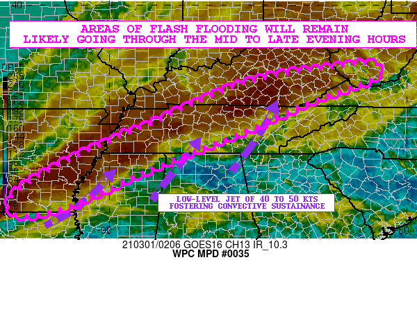
Areas affected...Lower MS/TN Valleys

Concerning...Heavy rainfall...Flash flooding likely

Valid 010210Z - 010710Z

SUMMARY...Areas of flash flooding will remain likely going into
the evening hours as a line of heavy showers and thunderstorms
continues to settle down to the southeast.

DISCUSSION...The latest radar and satellite imagery shows a broken
QLCS settling gradually down to the southeast across areas of the
lower MS and TN Valley region as it encounters a very moist and at
least modestly unstable airmass as supported by a 40 to 45+ kt
southwest low-level jet.

In fact, MUCAPE values from areas of southern AR to middle TN and
southeast KY are on the order of 500 to as much as 1000 j/kg with
PWs as high as 1.5 to 1.7 inches and this has been supporting
rainfall rates that have been on the order of 1 to 2 inches/hr.

The latest HRRR guidance favors additional rainfall amounts of as
much as 2 to 3 inches locally going through 06Z which will locally
be falling over areas of saturated if not at least somewhat
sensitive soil conditions. This will especially be the case across
portions of southern AR through northern TN, and across southeast
KY. In some areas of north-central TN and southeast KY there have
been several inches of rain over the last 36 hours, and thus the
additional rainfall is expected to largely lead to immediate
runoff.

As a result, expect there to be additional areas of flash flooding
going through the mid to late evening hours. In some cases, this
will exacerbate or prolong flooding for areas that have been
already seen significant runoff problems over the last several
hours.

Orrison

ATTN...WFO...HUN...JAN...JKL...LMK...LZK...MEG...MRX...OHX...
PAH...RLX...RNK...SHV...

ATTN...RFC...ABRFC...LMRFC...OHRFC...SERFC...NWC...

LAT...LON   38048123 37918094 37658097 37178212 36778326
            35938510 35308666 34878776 34378890 33219150
            32929298 33359340 34079262 35129063 36068840
            36598731 37308563 37708393 37908225
Last Updated: 911 PM EST Sun Feb 28 2021
|


