| WPC Met Watch |
|
|
Mesoscale Precipitation Discussion: #0007 (2021) |
|
(Issued at 339 AM EST Tue Jan 12 2021
) |
|
| MPD Selection |
|
|
|
|
|

Mesoscale Precipitation Discussion 0007
NWS Weather Prediction Center College Park MD
339 AM EST Tue Jan 12 2021

Areas affected...Western Washington & Western Oregon

Concerning...Heavy rainfall

Valid 120845Z - 121545Z

SUMMARY... An impressive atmospheric river continues to funnel
rich Pacific moisture over the Pacific Northwest. As a result,
periods of heavy rain may foster areas of urban and river
flooding, as well as further exacerbate ongoing flooding issues in
parts of the region.

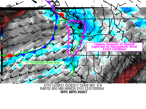
DISCUSSION... GOES West water vapor imagery shows a pronounced
atmospheric river originating in the subtropical North Pacific
aimed directly at the Pacific Northwest. The region remains
downwind of an intense 170-knot 250mb jet streak promoting upper
level divergence aloft. Strong WAA in the 850-700mb layer is also
supporting increased vertical motion within the atmospheric
column. In addition, brisk SW mean layer flow is also helping to
maximize lift along the windward sides of the Olympics, Cascades,
and coastal range. Mesoanalysis around 08Z showed a tongue of rich
850mb theta-e and PWs in excess of 1" reaching the Oregon coast.
The abundant feed of Pacific moisture have led to several
reporting stations reporting over 0.5" per hour rainfall rates
with many more hours to come throughout the morning.

Multiple upper level disturbances will ride along a cold front
that becomes quasi-stationary later today while a healthy fetch of
Pacific moisture remains fixed on the coast of the Pacific
Northwest. RAP guidance shows a swath of 1"+ PWs overspreading
western Washington, Oregon, and far northwestern California by
early morning. In fact, PWs engulfing the region are 2-3 STDs
above normal for the duration of this MPD. Winds are also forecast
to strengthen along the coast of Oregon and southwest Washington
with a potential coastal jet that may contain 850mb winds as
strong as 70 knots early this morning. This could further aid in
enhancing lift along the higher elevations bordering the coast,
especially where terrain is positioned orthogonal to the mean SW
wind flow. IVT values look to remain at a healthy and strong
600-800 kg/m/s throughout the early morning hours. Rainfall totals
for the duration of this MPD could range between 2-4" with locally
higher amounts possible in higher elevations.

The steady barrage of Pacific moisture means a long duration heavy
rainfall event looks to continue into the morning hours. The
longevity of rainfall rates of roughly 0.5-0.75" per hour in
mountainous terrain has potentially significant implications on
hydrologic impacts. Much above normal rainfall has been common
over the last two weeks with much of western Washington seeing
rainfall amounts anywhere between 150-300% percent of normal.
Farther south, while much of the Oregon coast does not have nearly
as wet of antecedent conditions as western Washington, they too
have also seen abnormally wet conditions over the last week.
Rivers and streams in these areas, especially in western
Washington and northwest Oregon, are most susceptible to rising
water levels in nearby rivers and streams, as well as any
localized urban flooding. Due to oversaturated soils, there is
also a heightened risk for mudslides near steep terrain.

Mullinax

ATTN...WFO...MFR...PQR...SEW...

ATTN...RFC...NWRFC...NWC...

LAT...LON   48622468 48262383 48262311 48432239 47792186
            46932188 46132229 45552248 44682261 43572308
            42982352 42152388 42212465 42932473 44782457
            46382457 47412473 48212490
Last Updated: 339 AM EST Tue Jan 12 2021
|


