| WPC Met Watch |
|
|
Mesoscale Precipitation Discussion: #0001 (2021) |
|
(Issued at 1045 AM EST Fri Jan 01 2021
) |
|
| MPD Selection |
|
|
|
|
|

Mesoscale Precipitation Discussion 0001
NWS Weather Prediction Center College Park MD
1045 AM EST Fri Jan 01 2021

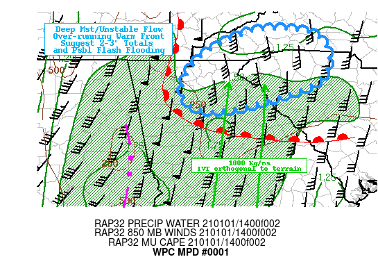
Areas affected...Northeast GA...Upstate SC...Western NC...

Concerning...Heavy rainfall...Flash flooding possible

Valid 011545Z - 012100Z

SUMMARY...Persistent upglide with potential embedded weak
convective elements across the southern slopes of the Applachians
pose 2-3" totals and isolated flash flooding concerns through
mid-afternoon/early evening.

DISCUSSION...GOES-E WV suite depicts a very impressive closed low
across the Central US with a compact peripheral shortwave moving
through N MS attm.  A line of broken convection across E AL
sliding into W GA has occasional GLM detected lightning flashes as
far north as Polk county.  These cells are active along eastward
advancing cold front and very near the intersection with the warm
front that resides just north of the ATL metro before angling
eastward toward AGS, being anchored into by strong damming
situation across N SC/W NC.

Very deep moisture along/ahead of the cold front is
unidirectionally transported from the boundary layer through about
5H with ample deep moisture running about 1.5-1.6" in Total PWats.
 The warm sector is generally running from mid-60s T and Tds
before ascending over the front, and yielding moderate instability
with MUCAPE over 500 J/kg up to the warm front ant 100-250 up to
the southern slopes of the Applachians.  Strong isentropic ascent
with 50-60kts of southerly 85-7H statured flow ideally interseces
the terrain and moderate showers are already filling in across N
GA/Upstate SC, even prior to the aligned moisture/instability
axis.   Integrated Vapor Transport (IVT) values are pushing 1000
kg/ms which runs in the 99th percentile for this time of year and
is stuggestive of anomolous rainfall production given the
increased instability/vertical development possible over the next
few hours.

Precursory showers will give way to deeper convection over the
next few hours from NE GA into Upstate SC and W NC.  With the
embedded convective elements potentially yielding .75-1"/hr totals
in the best orographic enhancment.  While 3H flow is note ideal
for further large scale synopic ascent (as right exit moves across
the area), the upstream shortwave energy pressing more north than
east should delay the frontal progression enough for a few hours
of potentially heavy rainfall.  Recent HRRR and HRRRv4 are
particularly bullish on the convective elements over-running the
cold wedge and intersecting terrain and have been performing well
with the timing/placement of the active convection in NW GA to
have some increased confidence in their heavier QPF solutions,
with 2-3" totals  through 21z, with some isolated totals over 3"
possible.

AHPS 2-week anomalies show a very dry region with the exception of
Oconee county, SC which is near normal, suggesting the FFG values
in the area are likely reasonable.  This would make the hourly
rain-rates likely below threshold but pushing 3-6hr totals
especially if moisture/instability axis remains slower progressing
and allows for the totals to reach over 3".  So by no means is
this a confident flash flooding situation; however, given the
strength of the flow/anomalous nature with orographic interaction
with shallow convection, isolated exceedance of FFG is possible
through 21z across the discussion area.

Gallina

ATTN...WFO...FFC...GSP...MRX...

ATTN...RFC...LMRFC...SERFC...NWC...

LAT...LON   35608288 35458166 34598166 33998343 34068431
            34588444 35168393
Last Updated: 1045 AM EST Fri Jan 01 2021
|


