WPC Home
About the WPC
WPC Product Information
Current Products
Experimental Products
Satellite Imagery
Latest Radar Imagery
Current Watches/Warnings
Storm Summaries
WPC Verification
Model Diagnostics/Verif.
Daily Weather Map
Development and Training
International Desks
Tropical Products
What's New
FAQs
Other Sites
Meteorological Calculators
|
|
Weather Prediction Center
College Park, MD
WPC Product Information
Jump to:
[QPF Overview]
[24-hr QPF]
[6-hr QPF]
[Excessive Rain]
[QPF Verification]
[Medium Range]
[Model Diagnostics]
[Surface Analysis]
[Short Range]
[Medium Range]
[Alaska Desk]
[International Desks]
[Storm Summaries]
[Tropical Public Advisories]
The following provides technical information
on the WPC for forecasters
and others interested in the details of
WPC operations.
WPC Mission
The Weather Prediction Center (WPC)
provides forecast, guidance, and analysis products and services to support
the daily public forecasting activities of the NWS and its customers, and
provides tailored support to other government agencies in emergency and
special situations.
We are here to assist and be a resource for you.
We are available 24 hours a day, 7 days a week to alert you to the potential
for significant weather events dealing with heavy rainfall or snowfall,
to discuss quantitative precipitation forecasts and model differences relating
to general weather and precipitation forecasts, and to provide forecast
guidance into the medium range period (days 3 to 7). Most of the forecasters
at the WPC have extensive experience at quantitative precipitation, heavy
snow and medium range forecasting.
|
Quantitative Precipitation Forecasts (QPFs)
Forecasters at the WPC [and its predecessor organizations,
NMC's Meteorological Operations Division, Heavy Precipitation Branch (HPB)
and the Quantitative Precipitation Branch (QPB)] have been issuing QPFs
since 1960. All QPFs incorporate the latest surface and upper air analyses,
radar data, satellite data, and model guidance from the NAM, NGM, GFS
and RUC displayed on N-AWIPS workstations. Forecasters also work
in conjunction with meteorologists in NESDIS's
Synoptic Analysis Branch (SAB) to obtain information regarding satellite
trends, precipitation and moisture availability estimates. This co-location
and collaboration between SAB and WPC is bureaucratically known as the
National Precipitation Prediction Unit (NPPU).
An WPC Senior Branch (lead) Forecaster (SBF) is
on shift at all times. He or she is responsible for producing the day 1 24-hour
precipitation forecasts, coordination of all WPC products (both internally
and with other NWS offices), and center administrative operations after
business hours. In addition to normal duties, the SBF participates in the
East Coast winter storm and NHC hurricane conference calls regarding heavy
precipitation, occasional unscheduled FEMA
conference calls and numerous media interviews.
|
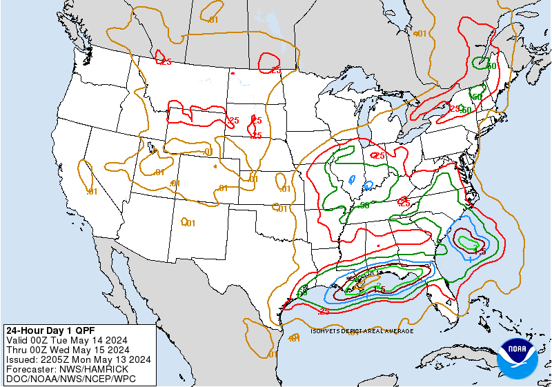
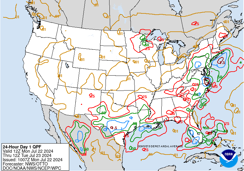
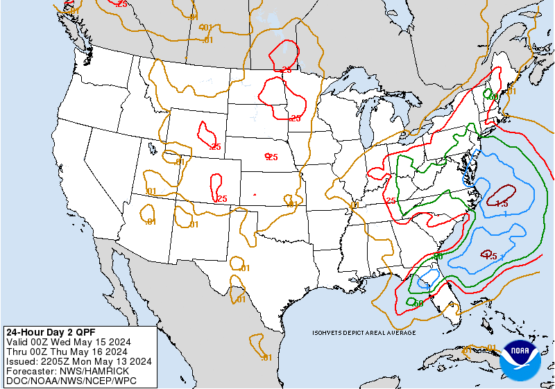
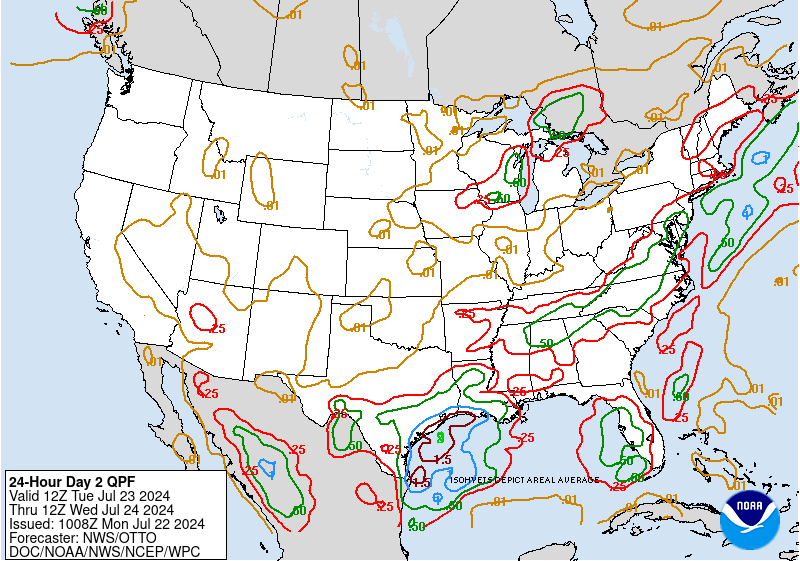
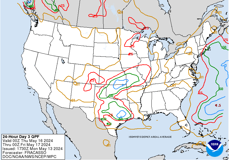
24 Hour QPFs
Isohyets of expected basin average rainfall of
0.01, 0.25 inch, 0.50 inch, 1 inch, and 1.50 inch and greater (in
inch increments) are drawn for the 24 hour forecast period ending at 1200Z
on both days 1, 2, and 3.
An electronically generated bulletin, which describes
the location of the forecast isohyets using latitude and longitude points,
is transmitted at the end of the qpf discussion for the Day 1 through Day
3 finals.
Example:
0.25 350731 349761 349789
347803 340819 327837 310854 297864 284874
0.50 404072 395071 390076
387081 389084 395085 402082 404076 404072
The first field is the value of the contour (in
this case...0.25" or 0.50"). The following fields are the latitude/longitude pairs
for the contour. The first three digits of the pair are the degrees of
latitude (in tenths of degrees North latitude). The last three digits of
the pair are the degrees of longitude (in tenths of degrees West longitude).
If the fourth digit is less than 5, a leading
"1" is added to indicate longitudes greater than or equal to 100° W.
From the above message, the following table gives the decoded lat/long
pairs:
| Value: 0.25" |
Value: 0.50" |
| 35.0N, 73.1W |
40.4N, 107.2W |
| 34.9N, 76.1W |
39.5N, 107.1W |
| 34.9N, 78.9W |
39.0N, 107.6W |
| 34.7N, 80.3W |
38.7N, 108.1W |
| 34.0N, 81.9W |
38.9N, 108.4W |
| 32.7N, 83.7W |
39.5N, 108.5W |
| 31.0N, 85.4W |
40.2N, 108.2W |
| 29.7N, 86.4W |
40.4N, 107.6W |
| 28.4N, 87.4W |
40.4N, 107.2W |
|
|
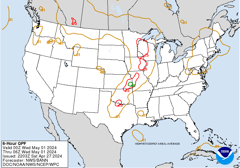
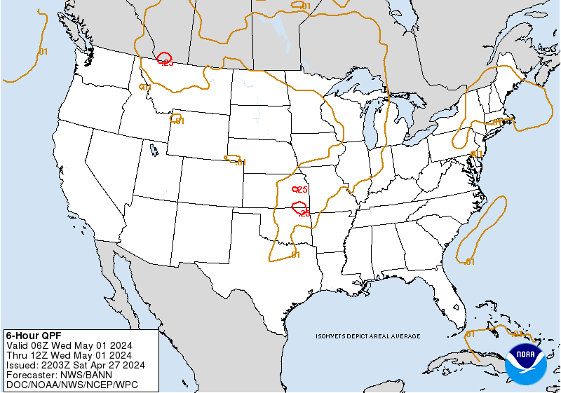
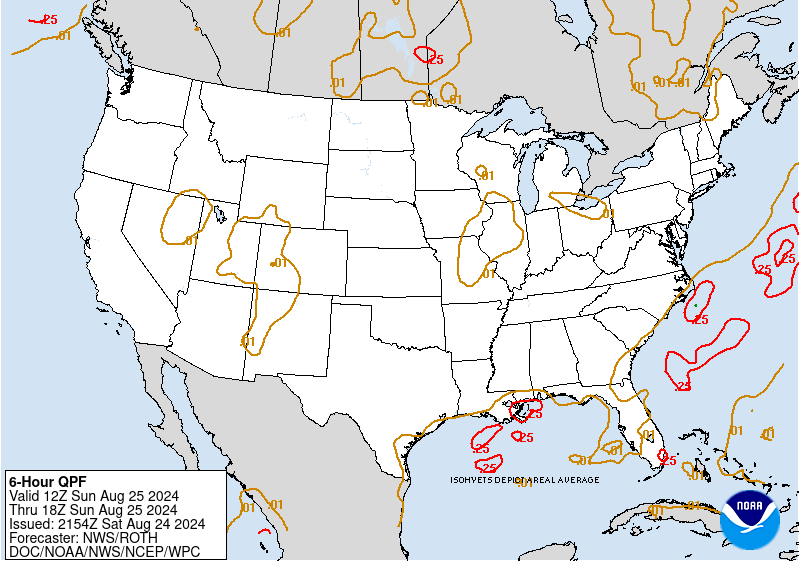
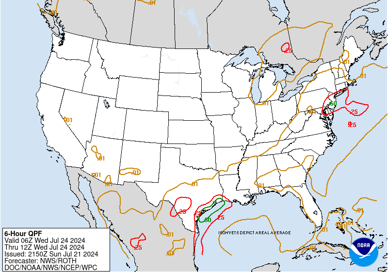
6 Hourly QPFs
| Product |
Valid Period |
Issuance Time |
| 92e,
93e,
9ee, &
9fe
|
12-18Z, 18-00Z,
00-06Z, 06-12Z |
1000Z |
| 9ge,
9he,
9ie, &
9je
|
Same as above but for Day 2 |
1000Z |
| 9ke,
9le,
9oe, &
9ne
|
Same as above but for Day 3 |
0800Z |
| 9pe & 9qe
| 12-18Z, 18-00Z (forecasts extend 12 hours
beyond the above Day 3 period) |
1000Z |
| 92e,
93e,
9ee, &
9fe
|
00-06Z, 06-12Z,
12-18Z, 18-00Z |
2200Z |
| 9ge,
9he,
9ie, &
9je
|
Same as above but for Day 2 |
2200Z |
| 9ke,
9le,
9oe, &
9ne
|
Same as above but for Day 3 |
2000Z |
These forecasts depict isohyets of accumulated
precipitation in inches expected in each six hour
period. The SBF generates the six-hourly forecast for Day 1. The QPF forecaster,
known as the Day 2/3 six-hourly forecaster, generates the Day 2 and Day
3 six hourly products during 2 shifts per day (~9am-5pm/9pm-5am EST), issuing
QPFs for eight consecutive six-hourly periods ending on synoptic hours. As of June 22, 2010, WPC began issuing
two additional 6-hour QPFs for the Day 3½ period once daily at 1000 UTC (5am EST).
|
Excessive Rainfall Potential
| The Excessive Rainfall graphics provide a forecast of the potential
for flash flooding across the continental United States.
As of October 5, 2004, the graphics display the probability that
precipitation will exceed the flash flood guidance values issued by the River Forecast Centers (RFCs).
A closed contour with an arrowhead will delineate the probability forecasts, with areas of threat
defined to the right of the direction of the arrowhead.
On June 29, 2006, the probability categories were changed due to calibration studies conducted at WPC.
The calibration for the excessive rainfall graphics are based on the frequency of events for which
observed rainfall exceeded FFG values for a given risk category.
Three probability categories are defined:
|
| Slight (SLGT) |
5-10% |
| Moderate (MDT) |
10-15% |
| High (HIGH) |
>15% |
|
|
If the potential exists for precipitation exceeding
guidance values, but the expected probability is less than 5%, WPC will place the words SEE TEXT
over the threat area. This area will then be referenced in the excessive rainfall discussion.
In addition, areas where precipitation is expected to exceed five inches will
also be indicated.
If conditions are not favorable or are not expected
to become favorable for flash flooding then "Rainfall Not Expected To Exceed
Flash Flood Guidance" is appended to the graphic.
The Day 1 graphics and associated discussion are issued four times per day, at 03, 06, 15, and 18 UTC.
The valid times of the products varies as noted in the table below. The 03 and 15 UTC issuances are
valid for 21-hour periods, while the 06 and 18 UTC issuances are valid for 30 hours. In addition,
if significant changes to the outlook are necessary, the forecaster has the option to issue
products at 00, 12, and 21 UTC.
On June 5, 2007, WPC began producing experimental Day 2 and Day 3 excessive rainfall forecasts.
Aside from the valid periods, there are several differences between these products and the Day 1 forecasts.
- Only two probability categories are defined - SLGT and MDT.
- No five-inch QPF areas will be indicated.
- There is no written discussion accompanying these products, but if an area is forecast, a text
representation of the threat region is created and can be accessed at the link below the graphic.
- Forecasts are issued only twice per day. See the table below for
information regarding issuance and valid times.
Day 2 and Day 3 excessive rainfall forecasts are based on Flash Flood guidance for Day 1 and quantitative precipitation
forecasts for Days 2 and 3. There is no Flash Flood guidance issued for Days 2 and 3. Flash Flood guidance will change
(increase or decrease) in response to future precipitation amounts. Increased variability in model guidance and the
inability of the models to resolve mesoscale features result in greater uncertainty forecasting excessive rainfall in the
day 2 and 3 period. WPC forecasters examine various deterministic and ensemble models looking for synoptic patterns
that favor organized areas of heavy rainfall and compare this to the Day 1 Flash Flood guidance before a threat region
is depicted.
Note: The definition of exceeding flash flood guidance is broad. Flash flood guidance
values depict the amount of rainfall necessary in a specific period of time to cause flash flooding
over a given area. The River Forecast Centers typically issue guidance values for 1-, 3-, and 6-hour
periods, and in some cases, 12- and 24-hour periods.
WPC forecasters make a determination of the threat that precipitation will
exceed any of the 1-hour, 3-hour, or 6-hour FFG values associated with the specific time interval in the valid time
period of the forecast. This product is not intended as a specific forecast of flash flooding, but
rather as a probabilistic indicator of rainfall amounts exceeding flash flood guidance over an area.
|
| Issuance and Valid Times
|
|
|
| Product |
Issuance Time |
Valid Time |
| 94e |
03 UTC |
03 UTC - 00 UTC (21 hours) |
|
06 UTC |
06 UTC - 12 UTC (30 hours) |
|
15 UTC |
15 UTC - 00 UTC (21 hours) |
|
18 UTC |
18 UTC - 00 UTC (30 hours) |
| |
| Optional 94e |
00 UTC |
00 UTC - 00 UTC (24 hours) |
|
12 UTC |
12 UTC - 12 UTC (24 hours) |
|
12 UTC |
12 UTC - 12 UTC (24 hours) |
|
21 UTC |
21 UTC - 00 UTC (27 hours) |
| |
| 98e |
0630 UTC |
12 UTC Day 2 - 12 UTC Day 3 |
|
1830 UTC |
00 UTC Day 2 - 00 UTC Day 3 |
| |
| 99e |
0830 UTC |
12 UTC Day 3 - 12 UTC Day 4 |
|
2030 UTC |
00 UTC Day 3 - 00 UTC Day 4 |
| |
| QPFERD Discussion |
Required
03, 06, 15, 18 UTC |
Same as associated 94e graphics listed above |
|
Optional
00, 12, 21 UTC |
Example 1:
A Day 1 (94e) issued at 1500 UTC June 5, 2007 will be valid from
1500 UTC June 6 - 0000 UTC June 7, 2007.
Example 2:
A Day 2 (98e) issued at 0630 UTC June 5, 2007 will be valid from
1200 UTC June 6 - 1200 UTC June 7, 2007.
Example 3:
A Day 3 (99e) issued at 2030 UTC June 5, 2007 will be valid from
0000 UTC June 8 - 0000 UTC June 9, 2007.
QPF Forecast Verification
6-hourly precipitation forecasts are verified
using a point (station) method while 24 hour forecasts are verified using
an areal method. Current graphs depicting WPC verification scores are available
on the WPC Verification page. For more details about the verification of WPC precipitation forecasts, read the article by Olson, Junker and Korty in Weather and Forecasting.Volume 10, 1995, pgs. 498-511.
|
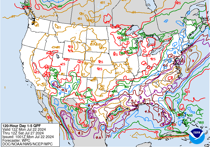
Medium Range (3-7 days)
The medium range graphical forecast products include:
- Surface pressure patterns, circulation centers, and fronts
for days 3-7 into the future
- Daily maximum and minimum temperatures and anomalies for days 3-7
- Daily precipitation probabilities for days 3-7
- Total 5-day precipitation for days 1 through 5
The surface pressure and fronts graphics are generated three times per day, while the Min/Max/PoP graphics
are issued twice per day. The 0900 UTC and 1400 UTC sets of graphics are preliminary and unofficial,
intended for inter-office coordination purposes only.
The surface pressure patterns and fronts on the
preliminary forecasts are only drawn for the continental U.S. The final set of
graphics is issued by 1900 UTC, with the surface pressure patterns and fronts encompassing
much of the Northern Hemisphere.
In addition to the graphical forecasts, the forecasters prepare three daily written discussions.
The preliminary narrative highlights medium-range model differences and provides initial model preferences,
and is available by 0900 UTC. This discussion is updated by 1400 UTC to include any possible changes
to MOS (Model Output Statistics) and incorporate global model ensemble guidance.
The final discussion incorporates the latest model guidance and updates forecast reasoning/model preferences.
In addition, it highlights any significant weather expected to impact the continental U.S.
and Alaska during the day 3-7 time frame. Forecasters also provide a separate discussion
describing model differences and preferences across Hawaii.
One meteorologist works during the overnight hours, while two prepare
the forecasts during the day shift (1030-1930 UTC). The overnight forecaster generates
the initial set of preliminary 3-7 day pressure systems/fronts and discussion due at 0900 UTC.
During the day shift, one of the meteorologists
updates the preliminary forecasts and, late in the shift, issues a final discussion and a set of 3-7 day
pressure systems/fronts.
The other forecaster prepares the 5-day precipitation, 3-7 day temperature and PoP progs, and Hawaiian discussion.
They routinely use output from the GFS, ECMWF, and UKMET medium
range models and also consider the Canadian, the Navy's NOGAPS model, the
MRFX, a semi-operationally experimental version of the GFS, and ensembles.
During hurricane season, at 1200 noon ET time on a daily basis since June
1, 1997, the medium range pressure forecaster participates in a conference
call with the NHC via the Hurricane Hotline to discuss current and potential
tropical activity in the Atlantic and Eastern Pacific oceans and how the
medium range models are handling the situation.
|
Model Diagnostics
The WPC model diagnostic meteorologist prepares the Model
Diagnostic Discussion which evaluates the NAM and GFS along with
other operational model and ensemble guidance for each significant system affecting the continental
U.S. through 84 hours from model initialization.
This discussion emphasizes model differences and preferences, with an evaluation of NAM/GFS analyses
if there are significant errors and a review of model trends and biases if appropriate.
There are four issuances during each of the day and night shifts corresponding to the arrival of latest model data.
The following table shows the deadline and content for each issuance.
|
| Issuance Time |
Content |
| 0315Z/1515Z |
Evaluate NAM initialization
Compare the NAM to latest runs of other models/ensembles
|
| 0445Z/1645Z |
Evaluate GFS initialization
Compare GFS to NAM and other guidance
Review NAM/GFS trends and biases as appropriate
Discuss model preferences
|
| 0530Z/1730Z |
Compare UKMET/Canadian global models to current guidance
Update model preferences as needed
|
| 0645Z/1845Z |
Evaluate latest ECMWF run
Finalize model preferences
|
During the cool season
(Nov 1 - Apr 15), this meteorologist is also primarily responsible for requesting
reconnaissance flights whenever the potential exists for major winter storm
development over the East or Gulf Coast states.
|
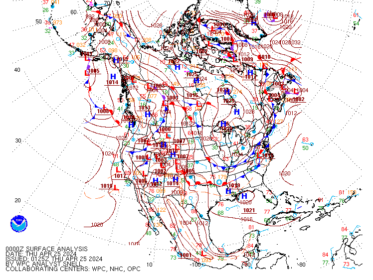
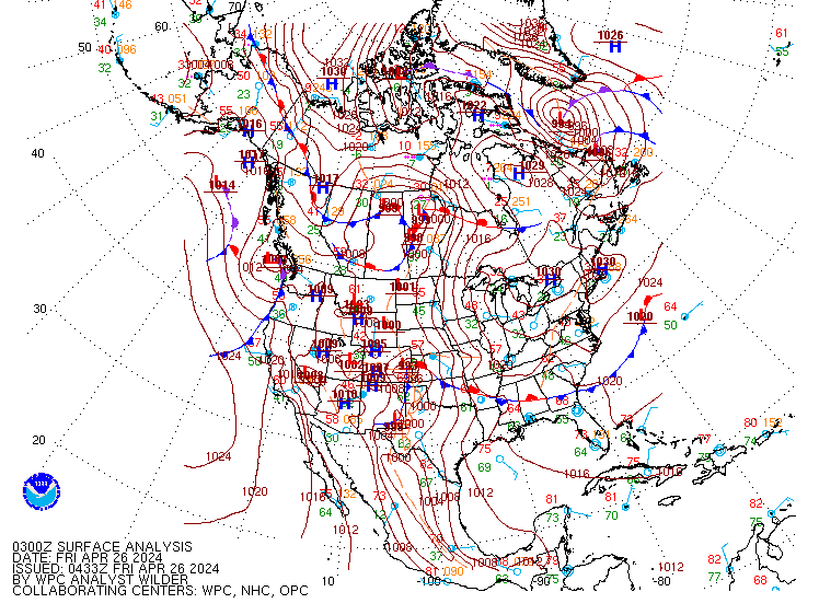
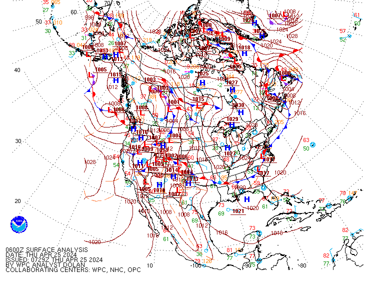
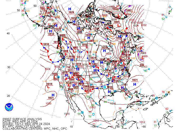
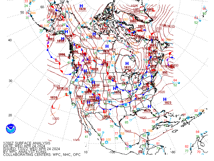
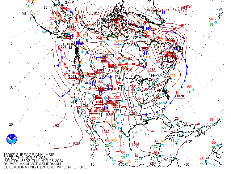
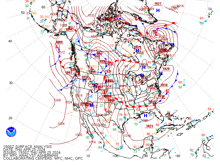
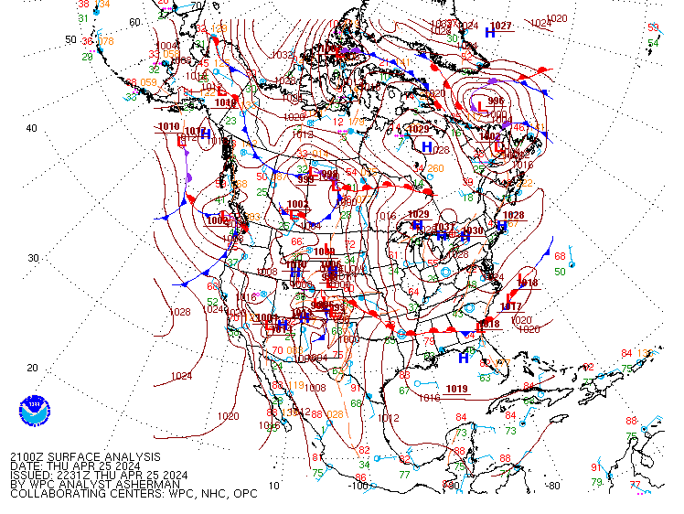
Surface Analysis Products
The following chart indicates the approximate issuance and web posting schedule for the WPC Surface Analysis. This product depicts the analysis of synoptic and sub-synoptic/mesoscale surface features including highs, lows, fronts, troughs,
outflow boundaries, squall lines, and drylines. The analysis domain covers most of North America, the Western Atlantic and Eastern Pacific oceans, and the Gulf of Mexico. In addition, a coded surface bulletin is created that
describes in text format the locations of highs and lows, fronts, and troughs.
| Analysis Time |
Issuance Time |
Web Posting |
| 00Z |
0115Z |
0145Z |
| 03Z |
0415Z |
0445Z |
| 06Z |
0715Z |
0745Z |
| 09Z |
1015Z |
1045Z |
| 12Z |
1315Z |
1345Z |
| 15Z |
1615Z |
1645Z |
| 18Z |
1915Z |
1945Z |
| 21Z |
2215Z |
2245Z |
PLEASE NOTE:
The Pacific Ocean analyses (East and West Pacific)
are now being done by NCEP's Ocean
Prediction Center and Tropical Prediction Center.
|
Probabilistic Heavy Snow/Icing Forecasts
|
PRODUCT DELIVERY SCHEDULE
The WPC Winter Weather Desk (WWD) is staffed two shifts a day from September
15 through May 15. The WWD forecaster routinely releases updated forecasts twice daily
at 0900Z and 2100Z (4am/pm EST or 5am/pm EDT respectively). Forecasts may be updated if
warranted by rapidly changing situations.
|
| PROBABILITY GRAPHICS FOR SNOW AND FREEZING RAIN
These graphics indicate the probability (potential)
for a location to receive specific thresholds of accumulated snow or ice.
-
Snowfall - closed lines represent the probability (slight, moderate,
and high) that enclosed areas will receive equal to or greater than a
specific threshold accumulation (4", 8" or 12") of snowfall in a 24 hour period.
-
Freezing Rain - depicts the probability in the same manner and time
period as snowfall, but with an accumulation threshold of .25" (one quarter of
an inch) of freezing rain.
Note the 4" threshold on the Snowfall Probability Graphic is drawn only for elevations less than 7,500 feet.
Elevationcriteria is not imparted for the 8" and 12" thresholds.
CAUTION ! The probability contours
may appear to inordinately expand, contract or "jump" geographically
after a scheduled update. This is partially due to the frequency
which the products are updated. The "new" 24 hour period covers
the last 12 hours of the previous issuance AND the next 12 hours.
Additionally two model cycles have passed since the last scheduled issuance.
Specific (deterministic) accumulations for a particular location in the United States
can be obtained via the National Weather Service home page.
Note, at this site you will have to click the GRAPHICAL FORECAST tab prior to clicking a location on the map.
The probabilistic graphics combined with the deterministic forecasts provide
a user both the most likely amount expected from an event and the potential the event will produce
accumulations in excess of specific thresholds.
|
|
PROBABILITY LEGEND
The probability thresholds used are defined as follows:
-
SLGT - 10% to 40% chance of occurrence within the outlined area.
-
MODERATE (MDT) - 40% to 70% chance of occurrence within the outlined area.
-
HIGH - 70% chance or greater of occurrence within the outlined area.
At times the forecasters may use only one or two isolines for the forecast.
This simply implies slight or slight to moderate probability for the
forecasted parameter.
To gain further insight into this forecast, please read the Heavy
Snow Discussion (HSD) that accompanies these graphical products.
|
|
LOW TRACKS GRAPHIC
These graphics
depicts the forecast location of significant surface lows impacting the
48 contiguous United States in 12 hour increments out to 72 hours into the future. It
is provided in two formats, non-technical and technical
- The non-technical version depicts the low position and track forecast by the NCEP WPC meteorologist in
white. Each low position is accompanied by a lead time (Eastern Time). The circle around each
low represents a 75% probability the observed low will be located within the circle. Note: The
probability is derived using previous season's verification data. For
reference, existing surface lows are depicted with a red marker without yellow circles.
- The technical version depicts the low position and track forecast by the NCEP WPC meteorologist in black.
Each low is accompanied by a forecast central pressure. Additionally there are no less than 35 different computer model
forecasts of low position for a given lead time available to the WPC
forecaster - these are depicted with symbols. Both the central
pressure and computer model forecasts are color coded according to lead
time (Universal Time). Together, the WPC forecast position of the low and
computer generated position provide a user both the
preferred position and track of the low and a sense of the uncertainty
with the forecast.
- For reference, existing surface lows are depicted with a red marker.
Surface lows can also be found on the WPC Surface Analysis. One can see the
current location surface lows and the forecast path of both existing surface
lows and surface lows expected to develop within three days time.
Note - winter weather is
not always associated with significant surface lows.
|
Short Range Forecasts
| Product |
Issuance Time |
| 6 and 12 hour forecasts |
0200Z (Night Shift) |
|
1400Z (Day Shift) |
| 18 and 24 hour forecasts |
0430Z (Night Shift) |
|
1630Z (Day Shift) |
| 30, 36, and 48 hour forecasts |
0730Z (Night Shift) |
|
1930Z (Day Shift) |
| 60 hour forecast |
0800Z (Night Shift) |
|
2000Z (Day Shift) |
| Discussion |
0900Z (Night Shift) |
|
2100Z (Day Shift) |
The short range meteorologist prepares 6 through 60 hour forecasts for
the continental U.S., southern Canada, and northern Mexico.
These products are issued twice daily using numerical model output from
the National Weather Service's (NWS) Global Forecast System (GFS) and North American
Mesoscale model (NAM), as well as guidance from the European Centre for Medium-Range Weather Forecasts
(ECMWF), the United Kingdom's Meteorology Office (UKMET), the Meteorological Service of Canada, including ensembles.
Coordination with the surface analysis, model diagnostics, quantitative precipitation,
winter weather, and tropical forecast desks is also performed during the forecast process.
The short range forecast products include surface pressure patterns (isobars), circulation centers and fronts for
6-60 hours, and a depiction of the types and extent of precipitation that are forecast at the valid time
of the chart. The primary goal is to depict accurately the evolution of major weather systems that will
affect the continental U.S. during the next 60 hours.
In addition, discussions are written on each shift and issued with the forecast
packages that highlight the meteorological reasoning behind the forecasts and significant weather across the continental United States.
Please note that at this time isobars are not included on the 6-hour forecast and precipitation is not included on the
60-hour forecast chart.
|
Alaska Medium Range (Days 4-8)
| Product |
Time |
| Day 4-8 Fronts and Pressure Graphics |
1800 UTC |
| Day 4-8 500 hPa Height Graphics |
1800 UTC |
| Alaska Medium Range Discussion |
1900 UTC |
| Day 4-8 Max/Min Temps and Probability of Precipitation Grids |
2200 UTC |
To accommodate a request for support from the NOAA National Weather Service (NWS) Alaska Region,
the NCEP/Weather Prediction Center's (WPC) Alaska Medium Range Desk is issuing the following
products:
- Day 4-8 Surface Fronts and Pressures graphics
- Day 4-8 500 hPa Height graphics
- Alaska Medium Range Forecast Discussion
- Day 4-8 Maximum/Minimum Temperature grids
- Day 4-8 12-hour Probability of Precipitation grids
- Day 4-8 derived Dewpoint Temperature, Cloud Cover, Precipitation Type, and Wind Speed/Direction grids
Surface graphics depict surface pressure patterns (from which surface winds can
be inferred), high and low pressure circulation centers and fronts for days 4-8. The
500 hPa height graphics display the general flow pattern forecast for days 4-8, and the gridded
guidance depicts various important meteorological variables for the forecast period.
An WPC meteorologist interprets available deterministic and ensemble model guidance and collaborates with
the WPC contiguous U.S. (CONUS) medium range forecasters. The Alaska forecaster then uses the
available model guidance and meteorological reasoning to depict the most likely scenario for days 4-8.
That meteorologist then composes a forecast discussion outlining deterministic and ensemble model differences,
preferences and trends.
In addition, within the discussion the forecaster communicates confidence level, forecast
uncertainty and any significant weather expected in the forecast period.
Winter Storm Summaries
Storm summaries provide both a summary of significant weather which has occurred,
and an WPC general forecast of the storm system over the next 1 to 2 days.
Storm summaries serve as a central source for storm information which would
otherwise have to be gleaned from a number of NWS Forecast Office websites.
Storm summaries are issued for significant large-scale storms which:
- Affect multiple NWS Forecast Office areas of responsibility
- Are likely to be of media interest
- Impact large population areas, or major transportation systems, or otherwise make a significant impact upon the nation's or a region's commerce
- Are usually snow and/or ice storms, but which may be rainfall events if they are causing widespread flash flooding, mudslides, etc.
If two or more separate storm systems are occurring simultaneously, a storm summary is issued for each individually.
Tropical Public Advisories
The WPC will issue public advisories after the National Hurricane Center
(NHC) discontinues its
advisories on subtropical and tropical cyclones that have moved inland,
but still pose a threat of heavy rain and flash floods in the
conterminous United States or adjacent areas within Mexico which affect
the drainage basins of NWS River Forecast Centers. The last NHC advisory
will normally be issued when winds in an inland tropical cyclone drop
below tropical storm strength, and the tropical depression is not
forecast to regain tropical storm intensity or re-emerge over water.
WPC advisories will terminate when the threat of flash flooding has ended.
|
Questions? Comments? Click here to send mail to the WPC.
Last Modified June 22, 2010
|
| | |