|
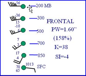
Comprised 25% of Maddox’s cases. The primary distinguishing characteristic for this type of event is an east-west frontal boundary with abundant moisture to its south. Precipitable water values in the Maddox et all study averaged around 1.60 inches or about 160% of normal on the warm side of the frontal boundary. In the frontal events studied, the warm moist air was forced to overrun the front so that heaviest rain typically fell on the cool side of the front. This type of event primarily occurs at night, possibly because of the nocturnal maximum in the LLJ documented by Bonner (1966). Wind speeds generally increased little from 850 mb through 300 mb although significant veering was present. The upper-level winds were usually found to parallel the front allowing convective cells to train over an area. |
|
850 mb |

|
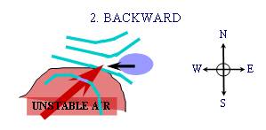
The greatest threat of excessive rain was skewed slightly to the right of a warm tongue of moist unstable air. 850 mb dew points were usually in the mid to upper teens within this “tongue” and K-indices were around 38. Since the best moisture inflow is often found along the western or southwestern portion of a Meso-scale Convective System (MCS), cells often redevelop along the western flank. This redevelopment can allow the most active convection to remain stationary or even propagate backwards. Schofield and Robinson (1990) have also presented a conceptual model for backwards propagating MCS. |


|
Note that that the moist unstable air with higher low level Θe is located upstream from the initial convection. Junker et at. noted that the low level moisture convergence is also located upstream (usually to the west) during frontal type of events during the 1993 Midwest floods. The Maddox frontal type system is essentially of Parker and Johnson leading stratiform type event. New cell development causes the MCS to move slower than the mean flow. |
|
Maddox and his colleagues noted that frontal heavy rainfall events often occurred near the 500 mb ridge where the mid level flow is fairly weak. The weak mean flow associated with many frontal type events makes it easier for propagation effects to offset cell motion. Also, the lack of shear in the cloud bearing layer, raises the potential for training of cells.
Doswell and his colleagues (1996) have suggested that the reason that MCSs and many flash floods develop near the 500h ridge axis may be be related to its synoptic scale subsidence suppressing convection which allows diabatic heating processes to steepen lapse rates and also allows for the accumulation of moisture in the area that later is used to fuel the MCS. They speculate that if convection developed earlier in the day it would process the moisture making less moisture and instability available to fuel the sustained convection needed for MCS development. |
|
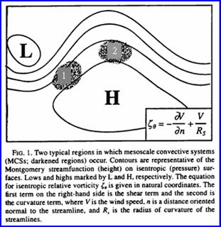
Blanchard et al. (1998) have suggested that a position near the axis of an upper level ridge is also an area of weak inertial stability. Therefore, when convection does develop near the ridge that the weak inertial stability associated with the anticyclonic curvature might make it easier to develop upper level divergence. Therefore, convection might be more likely to organize into an MCS where the upper level divergence is enhanced by the weak inertial stability. The region to the east or south of an upper level jet where the horizontal shear is anti-cyclonic is another area of weak inertial stability. |
|
Frontal type events often develop into training line-adjoining stratiform convective type systems with cells aligned parallel to the surface front but to its north. The line of thunderstorms are oriented parallel to the mean flow so cells train across an area. |
|
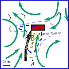
Adapted from Maddox et al. 1980 |
|
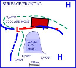
Adapted from Maddox et al. |

|
From Shumacher and Johnson 2006 |
|
Adapted from Maddox et al. 1980 |
|
Frontal type events are most common during the warm season when dynamics are weak. However, hybrid synoptic/frontal systems can occur across the south during the winter. |
|
Maddox Frontal Type heavy rainfall events |