![[.png Graphic]
Wind Barbs, Wind Speed (shaded) [Knots]\ Geopotential Height Contours [gpm]\700 mb - 00Z Thu 03-Sep 1998
Size: 42 Kb](http://nomads.ncdc.noaa.gov/tmp/nomads/orders/3928/meta/IMG16996.png)
![[.png Graphic]
Wind Barbs, Wind Speed (shaded) [Knots]\ Geopotential Height Contours [gpm]\250 mb - 00Z Thu 03-Sep 1998
Size: 42 Kb](http://nomads.ncdc.noaa.gov/tmp/nomads/orders/3928/meta/IMG16045.png)
|
Remnants of hurricanes in the East Pacific can help produce heavy rainfall across Oklahoma and Texas.
Two examples are presented below, Norma and Tico. These two example illustrate that convection indirectly associated with Pacific hurricanes can develop prior to a storm’s landfall in Mexico. |

|
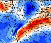
250-hPa height, and winds valid 0000 UTC 12 Oct. 1981 |
|
250-hPa height, and winds valid 0000 UTC 13 Oct. 1981 |


|
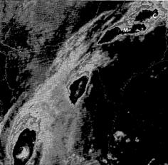
Infrared image v.t. 0000 UTC 12 Oct |

|
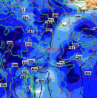
850-hPa height, and winds and 1000-hPa temperature (green, interval=2oK) valid 0000 UTC 12 Oct. 1981 |
|
At 0000 UTC Norma was still located off the coast of Mexico, convection had already developed across parts of northern Texas and Oklahoma along and north of an old frontal boundary. This boundary clearly shows up on the 1000-hPa temperature field below. The storm is located towards the entrance region of an upper level jet streak that starts near baja and extends northeastward into Texas. |
|
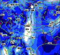
850-hPa height, and winds and 1000-hPa temperature (green, interval=2oK) valid 0600 UTC 13 Oct. 1981 |
|
The upper-level jet streak strengthened during the next 24 hours probably in response to the diabatic heating associated with the convection. A weak upper level trough was also embedded in the flow. It lifted northward during the night and worked in concert with the jet streak to increase the upper level divergence across the region which in turn probably acted to increase low level jet across Texas. |

|
The implied relationship between the track and precipitation may be misleading as the track used was not a low level center but was a mid-level vorticity center. No true low level circulation made it across the mountains. |
|
850-hPa geopotential height, winds and 1000-hPa temperatures valid 0000 UTC 18 Oct. 1983 |

|
A pre-existing front was also present prior to Tico and it too helped focus heavy rainfall across northern Texas and Oklahoma (see NARR analysis below). |

|
250-hPa height, and winds valid 0000 UTC 18 Oct. 1983 |

|
250-hPa height, and winds valid 1200 UTC 18 Oct. 1983 |
|
250-hPa height, and winds valid 0000 UTC 19 Oct. 1983 |
|
The entrance region of an upper level jet streak appear to play a role in enhancing the dynamics during each case. Note how the jet streak strengthens as a northern stream trough presses eastward and helps tighten the gradient. |

|
850-hPa geopotential height, winds and 1000-hPa temperatures valid 1200 UTC 18 Oct. 1983 |
|
850-hPa geopotential height, winds and 1000-hPa temperatures valid 0000 UTC 19 Oct. 1983 |

|
850-hPa geopotential height, winds and 1000-hPa temperatures valid 0000 UTC 19 Oct. 1983 |
|
250-hPa height, and winds valid 1200 UTC 19 Oct. 1983 |
|
Tico actually had a remnant low move across Mexico into Texas. However, the bulk of the rainfall fell along and north of the front across the region. When pondering whether heavy rainfall will develop in response to an east Pacific tropical system, look to a preexisting front and for some mechanism to strengthen the upper level jet streak that is helping enhance the low level convergence and upper level divergence in the vicinity of the front. |

|
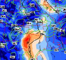
Let’s explore another case, one that produced much less rain than Lester even though the storms hit Mexico at about the same strength. Hurricane Isis (the red dot) lifts slowly northeast between 12 UTC 2 Sept and 00 UTC 3 Sept, the next 12 hours the storm weakens as it lifts northward. A trough/upper low that is developing off the California coast help pull Isis slowly north. However, the associated jet streak is very weak and Isis is located along the right front quadrant of this weak jet streak. More importantly during most of 24 hour period ending at 12 UTC 4 Sept., there is considerable shear with the easterly low level flow across Arizona and Mexico. Winds at 700 and 850 hPa |
|
00 UTC 3 Sept 1998 250-hPa geopotential heights and winds, red dot is Hurricane Isis, the magenta dot is the 12 UTC 2 Sept position. |
|
00 UTC 3 Sept 1998 700-hPa geopotential heights and winds, red dot is Hurricane Isis, the magenta do it the 12 UTC 2 Sept position. |
![[.png Graphic]
Wind Barbs, Wind Speed (shaded) [Knots]\ Geopotential Height Contours [gpm]\700 mb - 00Z Fri 04-Sep 1998
Size: 41 Kb](http://nomads.ncdc.noaa.gov/tmp/nomads/orders/3938/meta/IMG19485.png)
![[.png Graphic]
Wind Barbs, Wind Speed (shaded) [Knots]\ Geopotential Height Contours [gpm]\250 mb - 00Z Fri 04-Sep 1998
Size: 44 Kb](http://nomads.ncdc.noaa.gov/tmp/nomads/orders/3938/meta/IMG23093.png)
|
00 UTC 4 Sept 1998 250-hPa geopotential heights and winds . |
|
00 UTC 4 Sept 1998 700-hPa geopotential heights and winds, red dot is Hurricane Isis at 12 UTC 3 Sept position. |

|
24-hr hPC precipitation analysis valid 12 UTC 4 Sept. Remember only amounts greater than 0.50 inches are analyzed |

|
are easterly across Arizona and New Mexico at 00 UTC 4 Sept. Such flow is not as conducive to rainfall as deep southerly flow. |
![[.png Graphic]
Wind Barbs, Wind Speed (shaded) [Knots]\ Geopotential Height Contours [gpm]\700 mb - 00Z Sat 05-Sep 1998
Size: 41 Kb](http://nomads.ncdc.noaa.gov/tmp/nomads/orders/4191/meta/IMG26376.png)
|
00 UTC 5 Sept 1998 700-hPa geopotential heights and winds. |
![[.png Graphic]
Wind Barbs, Wind Speed (shaded) [Knots]\ Geopotential Height Contours [gpm]\250 mb - 00Z Sat 05-Sep 1998
Size: 41 Kb](http://nomads.ncdc.noaa.gov/tmp/nomads/orders/4191/meta/IMG4096.png)
|
00 UTC 5 Sept 1998 250-hPa geopotential heights and winds . |
|
24-hr hPC precipitation analysis valid 12 UTC 4 Sept. |
|
By 00 UTC 5 Sept., the ridge had shifted eastward and deep southerly flow was present across Arizona and the area of moderate to heavy rainfall consequently expanded. However, the rainfall associated with Isis was not nearly as impressive as with Lester, a storm that interacted with the right rear quadrant of an upper level jet streak and a storm that showed signs of extratropical transition. The contrast between the rainfall associated with Isis compared to other east Pacific storms that were discussed earlier in the section argues that deep southerly flow and a favorable interaction with a jet streak both act to increase the potential for heavy rains across the southwest. |