|
East Pacific storms |
|
Hurricanes and tropical systems that move into Mexico or track northeastward off the coast of Baja can produce wide ranges a precipitation. Some storms that move into Mexico are very wet across the southwest while others produce only spotty rainfall. The difference appears to be related to whether the basic synoptic pattern is favorable for pulling moisture northward into the southwest. Note how similar the 500-hPa pattern prior to Kathleen to the 500-hPa patterns that are typically associated with monsoonal surges into the southwest. A 500-hPa low off the coast and a strong ridge to the east. Such a configuration produces deep southerly flow. Another common factor is surface or 1000-hPa trough that extends northward across California. The rapid movement of the storm and abnormally warm ocean temperatures associated with an El Nino allowed Kathleen maintain its intensity more than |
|
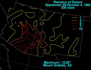
The coverage and amount of precipitation seems to be modulated by the speed of movement of the trough and by the strength of the southerly or southwesterly flow at 700 hPa, especially for those storms that dissipate and then indirectly produce sustained heavy rainfall. Tropical Storm Octave is a case in point. Octave moved northward and became a tropical storm on October 01, 1983. At 00 UTC 01 Oct., Octave was still located southwest of Baja, south of the bottom end of the 250-hPa analysis shown below. |

|
1000-hPa heights and Precipitable water anomalies (color shaded) valid 00 UTC 9 Sept 1976 |
|
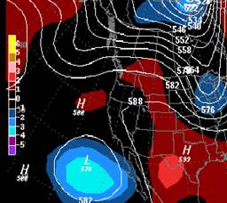
500-hPa geopotential heights and normalized departures from normal (color shaded) valid 00 UTC 9 Sept 1976. The red dot is the position of Kathleen. |
|
most storms with a similar track. Kathleen is one of five Pacific storms that have maintained strength enough to produce gale force winds over California. Almost 12 inches of rain fell over the mountains of southern California. Over half the town of Ocotillo was destroyed by flash flooding. Kathleen was one of the few southwest storms that produced significant flooding without interacting with an upper level jet streak. However, some storms can produce significant rainfall without being in the classic right rear entrance region of a jet streak (For example Octave). |

|
250-hPa geopotential heights, winds and isotachs v.t. 00 UTC 30 Sept 1983 |

|
250-hPa geopotential heights, winds and isotachs v.t. 00 UTC 01 Oct 1983 |

|
700-hPa geopotential heights, winds and isotachs v.t. 12 UTC 30 Sept 1983 |
|
The strong jet streak on the west side of the trough and the lack of any upstream kicker suggest that the upper trough will be very slow moving and that the upper low may actually dig southward. |
![[.png Graphic]
Wind Barbs, Wind Speed (shaded) [Knots]\ Geopotential Height Contours [gpm]\700 mb - 00Z Sun 02-Oct 1983
Size: 40 Kb](http://nomads.ncdc.noaa.gov/tmp/nomads/orders/3482/meta/IMG21598.png)
|
700-hPa geopotential heights, winds and isotachs v.t. 00 UTC 02 Sept 1983. The red dot is the approximate location of Octave |
|
A wind max at 700-hPa remained aimed at Arizona for 2 days with both analyses above suggesting speed convergence at 700-hPa. The winds at 850 were also from the south but were quite a bit weaker than at 700-hPa. Such deep southerly flow pulled moisture northward with an area of 1.40 inch or greater PWs extending into southern Arizona. The pattern was such that even without Octave, there probably would have been pockets of heavy rainfall across Arizona. Octave’s moisture served to enhance the rainfall. |
|
Portions of southeast Arizona were inundated and record peak flows were recorded on several large rivers. Clifton and Marana just north of Tuscon were devastated. Property damage was estimated to be $500,000. A report written in 1985 indicated that the flooding associated with Octave and the strong upper trough that it interacted with was the most damaging flood ever recorded in Arizona (Smith et al, 1985). |
|
The majority of east pacific storms that produce heavy rainfall across the southwest are associated with upper troughs and most are associated with an entrance region of an upper level jet maximum that helps to enhance the upper level divergence across the region. Norma (1970), Norman (1978), Lester (1992) and Olivia (1982) all were storms associated with and upper-level trough and the right rear quadrant of an upper level jet streak. Lester is a case in point. |

|
250 hPa geopotential heights, winds and isotachs v.t. 00 UTC 23 August 1992 |

|
700 hPa geopotential heights, winds and isotachs v.t. 00 UTC 23 August 1992. Red dot is NHC position of Lester. |

|
250 hPa geopotential heights, winds and isotachs v.t. 12 UTC 23 August 1992 |

|
700 hPa geopotential heights, winds and isotachs v.t. 12 UTC 23 August 1992. Red dot is NHC position of Lester. |
![[.png Graphic]
PWATclm at 00Z Sun 23aug1992
Size: 30 Kb](http://nomads.ncdc.noaa.gov/tmp/nomads/orders/3495/meta/IMG6035.png)
|
Precipitable water (mm) v.t. 00 UTC 23 August 1992 |
|
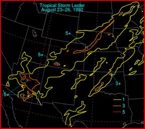
24-hour precipitation verifying at 12 UTC 23 Aug. 1992 |
|
MSL pressures lowered across Nevada and southern California in response to the upper trough digging towards Nevada and by 00 UTC 23 August, a surface low was located over southern Nevada. The low level southerly winds developed across western Arizona (not shown) ahead of Lester which helped pull a surge of anomalously high PW moved into Arizona. |


|
700 hPa geopotential heights, winds and isotachs v.t. 12 UTC 24 August 1992. Dashed red line is track of the remains of Lester. |
|
250 hPa geopotential heights, winds and isotachs v.t. 12 UTC 24 August 1992 |
|
Heavy rainfall occurred right as the storm made landfall over Baja. The location of the right entrance region over Arizona and the along stream variation of the winds within the jet, argue that strong upper level divergence should be going on across Arizona. |
|
Lester storm total precipitation |
|
Despite a surge of strong southerly winds across New Mexico in advance of Lester, the storm produced most of its rainfall in the southwest across Arizona and southwestern Colorado. Dickinson and his colleagues (2002) have noted that Lester underwent extratropical transition. Both Lester and Norman (1978) produced the bulk of their rainfall to the west suggesting that some eastern Pacific storms may undergo extratropical transition and have their precipitation shield shift to the northwestern side of the storm. |
|
Effects over Southwest U.S. |