| WPC Met Watch |
|
|
Mesoscale Precipitation Discussion: #1108 (2021) |
|
(Issued at 416 PM EDT Tue Oct 26 2021
) |
|
| MPD Selection |
|
|
|
|
|

Mesoscale Precipitation Discussion 1108
NWS Weather Prediction Center College Park MD
416 PM EDT Tue Oct 26 2021

Areas affected...Southeast New England

Concerning...Heavy rainfall...Flash flooding possible

Valid 262015Z - 270215Z

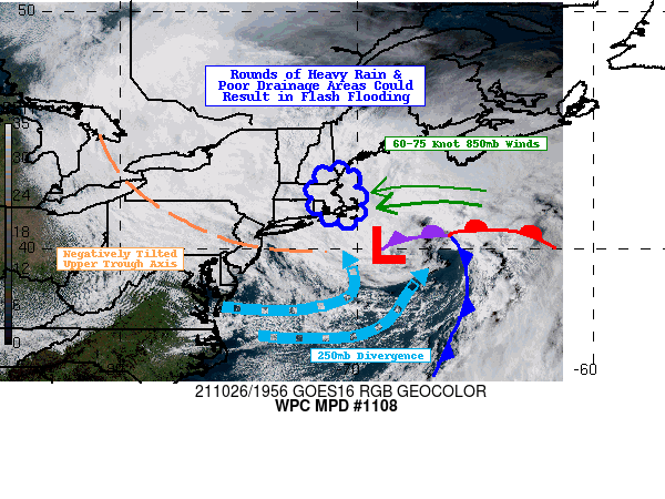
SUMMARY...Powerful cyclone to deliver heavy rainfall and whipping
winds to southeastern New England this evening. Excessive rainfall
rates combined with increasingly poor drainage conditions may lead
to areas of flash flooding.

DISCUSSION...A negatively tilted upper level trough over the
Northeast is causing tremendous divergence atop the troposphere
off the Northeast coast courtesy of positive vorticity advection
streaming out ahead of the trough. The result has been a rapidly
strengthening storm system off the Northeast coast that will
continue to do so into the overnight hours. The intensifying
cyclone is working in tandem with a strong area of high pressure
over eastern Canada to tighten the pressure gradient over the
region, forcing easterly low level winds to accelerate. These
roaring easterly low level winds (RAP guidance shows 850mb winds
of 60-75 kts later this evening) are set to deliver a steady
barrage of rich Atlantic moisture into southern New England.
Latest RAP guidance indicates anywhere from 1.2-1.4" of
precipitable water surges into southeast New England tonight,
values that are roughly 1.5-2 STDs above normal.

To emphasize how strong the onshore flow is, the 12Z GFS indicates
that by 00Z this evening, 925mb winds are 3-4 STDs above normal
and only continue to increase just before midnight. Integrated
Vapor Transport (IVT) according to the 12Z GFS exceeds 1000 kg/m/s
overhead while at the same time, a robust 850-700mb front
approaches from the south and east. The low level frontogenetical
support along with strong vertical ascent within the atmospheric
column allows for a swath of precipitation that looks to fall
heavily at times this evening. 12Z HREF is identifying the
potential for 3-hourly totals over 1" with heavier totals closer
to 1.5" within the heaviest bands of rainfall.

Flash Flood Guidance (FFG) is lowest along the eastern coast of
Massachusetts with hourly values as low as 1" near the Boston
metro area. Even 3-hour FFG indicates flash flooding could
transpire with 1.5" of rainfall in parts of the region. One big
wild-card is the arrival of strong winds this evening that will
strip many leaves off trees across much of southeastern New
England. The addition of leaves littering sides of roads and
clogging nearby streams and drainage areas would exacerbate the
flood threat throughout the region later tonight. In summary,
flash flooding is possible thanks to rainfall totals approaching
1-3 hour FFG values and an abundance of leaves falling off trees
causing drainage issues throughout the evening.

Mullinax

ATTN...WFO...BOX...GYX...

ATTN...RFC...NERFC...NWC...

LAT...LON   43347054 43137022 42677008 41916983 41476980
            41196996 41237099 41597164 42317193 42957158
            43297112
Last Updated: 416 PM EDT Tue Oct 26 2021
|


