| WPC Met Watch |
|
|
Mesoscale Precipitation Discussion: #1102 (2021) |
|
(Issued at 1139 PM EDT Sun Oct 24 2021
) |
|
| MPD Selection |
|
|
|
|
|

Mesoscale Precipitation Discussion 1102
NWS Weather Prediction Center College Park MD
1139 PM EDT Sun Oct 24 2021

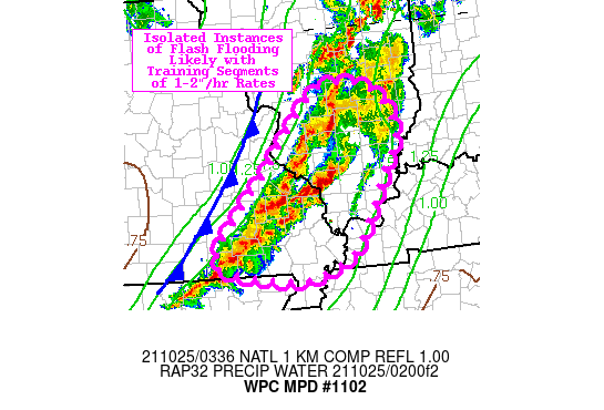
Areas affected...Southeastern Missouri...Southern Illinois

Concerning...Heavy rainfall...Flash flooding likely

Valid 250338Z - 250700Z

Summary...Isolated instances of flash flooding are likely over the
next several hours with semi-discrete segments of convection
capable of 1-2"/hr rainfall rates, training/repeating locally.

Discussion...Vigorous, semi-discrete/linear convective segments
are ongoing along and ahead of a cold front progressing across
southern MO/IL. The mesoscale environment is characterized by
PWATS of 1.5-1.7 inches (above the 90th percentile
climatologically), MUCAPE of 1000-2000 J/kg, and strong moisture
transport on the back of an impressive low-level jet (45-55 kts at
850 mb). Tremendous amounts of deep layer shear (~50 kts) have
acted to organize convection into complex semi-discrete/linear
segments with embedded supercells, and rainfall rates associated
with the strongest cores has reached 1-2"/hr (even exceeding 2"/hr
locally per dual-pol radar estimates). Since some of this deep
convection was able to form farther out ahead of the front within
the warm sector, there is a bit of training/repeating that is
occurring as the clearing line of storms (i.e. convection nearest
to the front) catches up with earlier pre-frontal deep convection.
This is resulting in localized totals approaching 3-4 inches over
a relatively short period (~3-4 hours) which should easily exceed
the 3-hr FFG of 2-3 inches. However, the highly progressive nature
of the storm system (850-300 mb mean wind of 50 kts) will act to
limit the time frame for flash flood impacts through about 07z as
convection moves rapidly east and is gradually replaced by a
drier, post-frontal air mass.

Churchill

ATTN...WFO...ILX...LSX...MEG...PAH...SGF...

ATTN...RFC...LMRFC...NCRFC...OHRFC...NWC...

LAT...LON   39188921 39078844 38468803 37868833 37398857
            36968883 36728899 36478951 36399017 36649145
            36959141 37599087 37999046 38898970
Last Updated: 1139 PM EDT Sun Oct 24 2021
|


