| WPC Met Watch |
|
|
Mesoscale Precipitation Discussion: #0982 (2019) |
|
(Issued at 913 AM EST Sat Dec 14 2019
) |
|
| MPD Selection |
|
|
|
|
|

Mesoscale Precipitation Discussion 0982
NWS Weather Prediction Center College Park MD
913 AM EST Sat Dec 14 2019

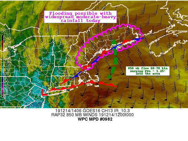
Areas affected...Eastern NH and Maine

Concerning...Heavy rainfall...Flash flooding possible

Valid 141412Z - 142012Z

Summary...Widespread moderate rainfall today will produce 1 to 2
inch totals along coastal New Hampshire and Maine. With saturated
soils across the region, flooding or runoff problems will be
possible.

Discussion...Regional radar imagery this morning across New
England shows widespread rainfall associated with an area of low
pressure located around NYC and a surface boundary extending along
the coast. Aloft, water vapor imagery and 500 mb heights depicts
an impressive shortwave trough moving through the central
Appalachians, providing the large scale forcing for ascent across
much of the region. The most recent RAP mesoanalysis has fairly
impressive low to mid level frontogenesis lifting through the
region, contributing to the rainfall rates of around 0.5"/hr.
Finally, the RAP forecast through 21Z shows impressive 850 mb flow
of 60-70 kts converging on the coast, bringing in PWs of around
1.25" per recent blended TPW product. These values are between 3-4
SD above the mean.

There is a fairly consistent signal in the most recent hi-res data
for the axis of moderate to locally heavy rainfall to continue
across coastal Maine. Amounts of 1-2" will be common with some
localized amounts near 3" possible. These totals over the course
of 6 hours will approach some of the 3 and 6 hour FFG values,
particularly across coastal Maine.

Further inland, the most recent NOHRSC analysis indicates the
snowpack to be mainly across interior NH and ME with a SWE of
around 2 inches. The combination of any melting and the widespread
rainfall could lead to runoff/flooding issues as well.

Widespread rainfall of 1-2" (locally 3") has occurred from
portions of MA, NH and southern ME. This has reduced the FFGs and
contributed to higher streamflows according to the National Water
Model. With the expected additional rainfall and antecedent
conditions, some instances of flooding or runoff will be possible
across portions of NH and ME through the afternoon.

Taylor

ATTN...WFO...BOX...CAR...GYX...

ATTN...RFC...NERFC...

LAT...LON   45696824 45576734 45156687 44816696 44316781
            43976879 43706960 43287026 42697064 42607075
            43197151 44487075 45146959
Last Updated: 913 AM EST Sat Dec 14 2019
|


