| WPC Met Watch |
|
|
Mesoscale Precipitation Discussion: #0966 (2021) |
|
(Issued at 253 PM EDT Tue Sep 14 2021
) |
|
| MPD Selection |
|
|
|
|
|

Mesoscale Precipitation Discussion 0966
NWS Weather Prediction Center College Park MD
253 PM EDT Tue Sep 14 2021

Areas affected...Upper Texas Coast, Southern Louisiana, far
Southern Mississippi

Concerning...Heavy rainfall...Flash flooding likely

Valid 141852Z - 150000Z

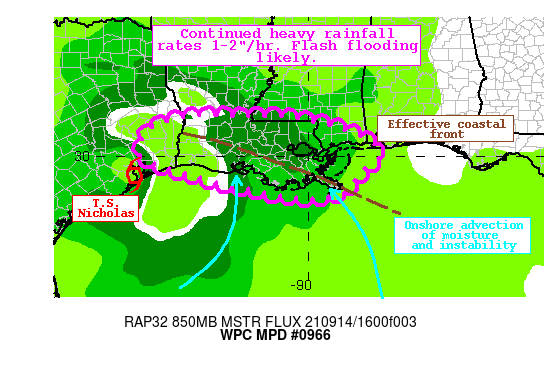
Summary...Heavy rainfall associated with Tropical Storm Nicholas
will continue to plague portions of the Central Gulf Coast through
this evening. Rain rates of 1-2"/hr are likely, which could
produce 1-3" of rain with local amounts to 5". Flash flooding is
likely.

Discussion...Tropical Storm Nicholas was located at 1800 UTC about
30 miles SE of Houston, TX moving ENE at 7mph. The center of
circulation is clearly evident on the regional radar mosaic, with
heavy rainfall almost exclusively confined east and well east of
the center. Recently, some narrow convergence bands had developed
east of Galveston Bay with heavy rain lifting again into the far
Upper Texas Coast, but otherwise most of the rainfall was east of
Vermilion Bay and across southeast Louisiana where recent rainfall
rate estimates from KLIX were as high as 2"/hr. This has led to
CREST unit streamflow measurements above 700 cfs/smi, and flash
flooding is continuing across the area.

As T.S. Nicholas continues to drift eastward through this evening,
heavy rain will persist near the Central Gulf Coast. Guidance has
trended a bit eastward with the heaviest rainfall, and this
appears to be due to some drier continental air which is advecting
around Nicholas and is clearly evident in CIRA LPW fields. East of
this drier air, the thermodynamics remain extremely favorable for
heavy rainfall with PWs of 2.1 to 2.3 inches on the special 18Z
U/A soundings from KLIX and KLCH, respectively. Additionally,
freezing levels are near 16,000 ft, suggesting efficient warm rain
processes. This is leading to widespread rainfall rates of around
1"/hr, and the HREF probabilities indicate an increasing
likelihood for 2-3"/hr this evening, focused in southeast
Louisiana.

Despite drier air approaching from the west, there is likely to be
a window of significant overlap of forcing and moisture to drive
excessive rainfall through this evening. A pronounced inflow band
continues to extend into the Gulf of Mexico on the leading edge of
this drier air, while an effective coastal/warm front lies near
the coast of Louisiana at the nose of the WAA/LLJ serves as an
additional focus for low-level convergence. As Nicholas shifts
eastward, 925-850mb flow should increase out of the S/SW to more
impressively shift moisture and instability northward, while at
the same time the S/SE flow from the central Gulf intensifies.
This could produce a situation where the most intense moisture
advection within the primary inflow band begins to isentropically
ascend the slow moving effective front, leading to an axis of
continuous 2"+/hr rainfall. The exact placement of this still
varies within the various high-res guidance, but the trend has
been to focus over far southern Louisiana, with recent runs of the
HRRR all shifting SE, to be more aligned with the CONEST and ARW2.
Where this occurs, additional rainfall in excess of 5" is
possible, with 1-3" expected elsewhere across the region. Flash
flooding is likely.


Weiss

ATTN...WFO...HGX...JAN...LCH...LIX...MOB...

ATTN...RFC...LMRFC...SERFC...WGRFC...NWC...

LAT...LON   31169223 31159094 31069010 30878934 30558844
            30248799 29968799 29958799 29828811 29538856
            29098882 28838947 28869070 29059163 29219245
            29409317 29599377 29749434 30029479 30599472
            30959419 31149338
Last Updated: 253 PM EDT Tue Sep 14 2021
|


