| WPC Met Watch |
|
|
Mesoscale Precipitation Discussion: #0925 (2021) |
|
(Issued at 322 PM EDT Wed Sep 01 2021
) |
|
| MPD Selection |
|
|
|
|
|

Mesoscale Precipitation Discussion 0925
NWS Weather Prediction Center College Park MD
322 PM EDT Wed Sep 01 2021

Areas affected...Northern Mid-Atlantic States into Southern New
England

Concerning...Heavy rainfall...Flash flooding likely

Valid 011920Z - 020120Z

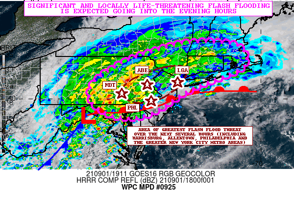
SUMMARY...Significant and locally life-threatening flash flooding
is expected across areas of the northern Mid-Atlantic and southern
New England going into the evening hours as heavy rainfall
associated with Ida crosses the region.

DISCUSSION...The latest GOES-16 visible satellite imagery in
conjunction with area dual-pol radar and surface observations
shows the extratropical low center of Ida crossing northwest VA
very close to the town of Winchester. Ida continues to accelerate
off to the east-northeast as an upper trough amplifies in across
the central Appalachians and advances into the Mid-Atlantic region.

The MRMS-based radar analyses including the latest KDP/ZDR data
continue to show extremely efficient warm/tropical rain processes
ongoing within a large shield of heavy rainfall focused along and
to the left of the track of Ida and north of a downstream warm
front. This has allowed for significant rainfall and resulting
flash flooding to already occur across large areas of
south-central to eastern PA, and with rain increasing in coverage
and intensity well off to the northeast across southeast NY and
into southern New England.

Very strong low to mid-level forcing continues to drive this
enhanced rainfall with a combination of strong 925/700 mb
frontogenesis, modest elevated instability, and strongly divergent
flow aloft associated with a strengthening mid to upper-level
deformation zone all working in tandem as Ida advances off to the
east-northeast.

For areas closer into the low center itself and into the warm
sector, there is a substantial area of strong and well-organized
supercell convection. This has been impacting areas of
central/eastern MD, D.C, and far southeast PA over the last 1 to 2
hours. Significant cloud-top cooling has been noted with this
activity as strong shear parameters and moderate to strong
instability pools along the warm front lifting northeast across
the region.

The 12Z HREF suite of guidance and recent HRRR runs show a gradual
northeast expansion/track of particularly heavy and focused
rainfall impacting areas along and north of the path of Ida going
through the balance of the afternoon and the early to mid-evening
hours. There is the expectation of seeing some hourly rainfall
amounts of 2 to 3+ inches with the more organized and
consolidating areas of convection that are expected to impact
southeast and east-central PA, central and northern NJ, far
southeast NY (including the greater New York City area), and
eventually Long Island. Additional storm total amounts going
through the mid-evening hours should be as much as 4 to 6 inches
with isolated heavier amounts.

Widespread flash flooding is expected, and some of it is likely to
be significant and potentially life-threatening given the high
rainfall rates and storm total potential. Flash flood emergency
level rainfall impacts will be possible as we head into the
evening hours, and this will include some of the major cities of
the I-95 urban corridor from Philadelphia to New York City along
with adjacent suburbia. Additional MPDs will be issued accordingly
into the evening and overnight time frame as Ida crosses the
Mid-Atlantic region and aims toward southern New England.

Orrison

ATTN...WFO...ALY...BGM...BOX...CTP...LWX...OKX...PHI...

ATTN...RFC...MARFC...NERFC...NWC...

LAT...LON   42697258 42507107 41647074 41027191 40687289
            40187385 39847436 39257541 39147675 39657789
            40307815 40927781 41697657 42157539 42547399
Last Updated: 322 PM EDT Wed Sep 01 2021
|


