| WPC Met Watch |
|
|
Mesoscale Precipitation Discussion: #0879 (2019) |
|
(Issued at 916 PM EDT Sat Sep 21 2019
) |
|
| MPD Selection |
|
|
|
|
|

Mesoscale Precipitation Discussion 0879
NWS Weather Prediction Center College Park MD
916 PM EDT Sat Sep 21 2019

Areas affected...Southwest TX

Concerning...Heavy rainfall...Flash flooding likely

Valid 220116Z - 220546Z

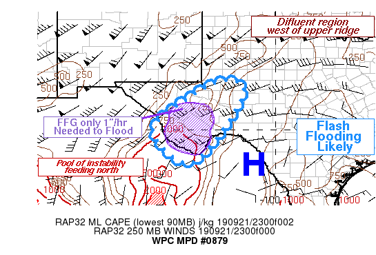
Summary...Highly anomalous moisture content will yield
pseudo-tropical rainfall through 05Z. Soils are wet, with minimal
heavy rain needed to cause creeks and streams to rise. Flash
flooding is possible from the Davis Mountains to Big Bend through
late evening.

Discussion...At 01Z thunderstorms had begun to line up and train,
prompting a Flash Flood Warning west of Fort Stockton. While the
broader southern Plains were somewhat a mess of widespread
convective initiation and various outflows, the mesoscale seems to
favor a more organized heavy rain threat over southwest Texas for
at least a few hours this evening. The SPC mesoanalysis depicted a
corridor of moderate ML CAPE off the Mexican plateau region,
tapering to the low end of moderate but in a fairly broad swath
from the Davis Mountains to the Stockton Plateau and the Big Bend.
Southerly inflow here will feed convection over the new few hours,
supported aloft by persistent difluence often found to the
immediate northwest side of an upper ridge.

With all this occurring downstream of the tropical moisture stream
that had produced cyclones Lorena and Mario in the eastern
Pacific, and in the low level wake of former Atlantic system
Imelda, moisture content was unusually high through a deep layer.
Precipitable Water was observed at about 1.65 inches at Del Rio
this evening, but the SPC and RAP analyses estimated PW as high as
1.80 inches farther west toward the Big Bend. This would be at
least 2.5 to near 3.0 standard deviations above September
climatology for that area, and should support very heavy,
tropical-like rain rates. Adding to the flash flood equation, rain
in recent days had lowered flash flood guidance such that only
about 1 inch in an hour or 1.5 to 2.0 inches in 3 hours is needed
to cause bankful conditions. The hi-res models show a distinct
signal for concentrated heavy rain here through at least 05Z, and
with so many ingredients aligning, including the model signal, it
would appear that a few instances of flash flooding are likely.
Judging by outflow placement at 01Z, the risk should be more
pronounced south of Midland/Odessa, although some small scale
heavy rainfall may skirt this area as well.

Burke

ATTN...WFO...MAF...SJT...

ATTN...RFC...WGRFC...

LAT...LON   32050205 31520133 29290274 28660382 30000504
            31390350
Last Updated: 916 PM EDT Sat Sep 21 2019
|


