| WPC Met Watch |
|
|
Mesoscale Precipitation Discussion: #0819 (2020) |
|
(Issued at 651 PM EDT Sat Oct 10 2020
) |
|
| MPD Selection |
|
|
|
|
|

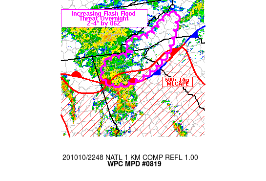
Mesoscale Precipitation Discussion 0819
NWS Weather Prediction Center College Park MD
651 PM EDT Sat Oct 10 2020

Areas affected...northern GA into western SC/NC

Concerning...Heavy rainfall...Flash flooding possible

Valid 102250Z - 110450Z

SUMMARY...Showers and thunderstorms will increase over the
southern Appalachians through 06Z with rainfall rates in excess of
1 in/hr at times. Flash flooding will be possible from 2-4 inches
of rain in a few locations by 06Z.

DISCUSSION...Regional radar imagery from 2230Z showed an arc of
showers and thunderstorms extending from northwestern GA into
southeastern AL, moving toward the northeast and east. The region
of convection was tied to an axis of low level convergence in the
925-850 mb layer as seen on recent VAD wind plots. VAD wind plots
at KFFC and KJGX were 30-40 kt from the SSE at 850 mb and 25-30 kt
from the SE/SSE at 925 mb, just ahead of the region of
showers/thunderstorms. Precipitable water values were more than
sufficient to support heavy rain with GPS values between 1.8 and
2.0 inches across central GA to central SC with these values
likely extending northward, close to the foothills of the southern
Appalachians. Instability was somewhat of a limiting factor for
heavy rain over the terrain with MLCAPE between 500 and 1000 J/kg
along and south of a quasi-stationary front draped south of the
Appalachian chain (via the 22Z SPC mesoanalysis).

As the low to mid-level reflection of Delta approaches from the
west over the next 6 hours, the arc of showers and thunderstorms
over northwestern GA will advance eastward with low level flow
backing out ahead of the low level convergent axis into the
southern Appalachians. Shower and thunderstorms coverage should
increase over northeastern GA and the western Carolinas over the
next 2-4 hours along with cell repeating and training. While no
appreciable increase in instability is expected beyond 00Z, some
increase in 850-700 mb layer dewpoints will support modest
increases in precipitable water with overrunning of the stationary
front augmented by upslope flow into the south and east facing
slopes of the southern Appalachians. Rainfall rates may struggle
to exceed 1 in/hr, but persistent coverage of heavy rain could
produce flash flooding from 2-4 inches of rain in a few locations
by 06Z.

Otto

ATTN...WFO...FFC...GSP...MRX...

ATTN...RFC...LMRFC...SERFC...NWC...

LAT...LON   36068172 35908167 35418194 34868226 34348293
            33968389 33918456 33988496 34108516 34418520
            34648503 34838467 34798425 34838405 34958383
            35078382 35168399 35258400 35328385 35388358
            35358320 35428291 35518276 35858228 36028192
Last Updated: 651 PM EDT Sat Oct 10 2020
|


