| WPC Met Watch |
|
|
Mesoscale Precipitation Discussion: #0776 (2022) |
|
(Issued at 254 PM EDT Wed Aug 17 2022
) |
|
| MPD Selection |
|
|
|
|
|

Mesoscale Precipitation Discussion 0776...Corrected
NWS Weather Prediction Center College Park MD
254 PM EDT Wed Aug 17 2022

Corrected for typo in headline

Areas affected...West Texas and Southern New Mexico

Concerning...Heavy rainfall...Flash flooding possible

Valid 171839Z - 180000Z

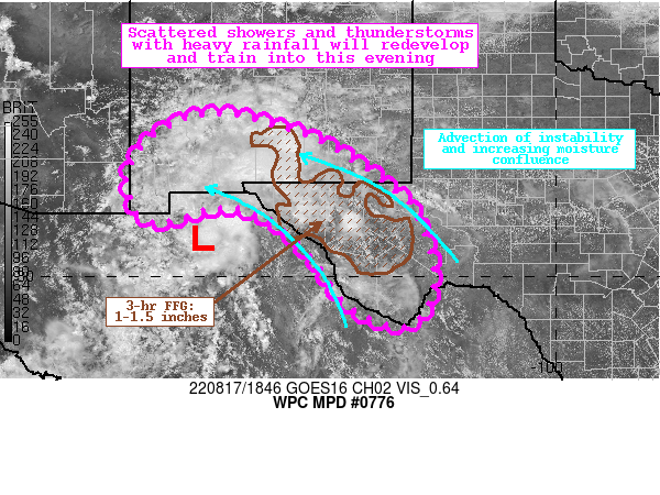
Summary...Showers and thunderstorms developing east of a remnant
tropical disturbance will train across West Texas and southern New
Mexico through this evening. Rainfall rates of 2"/hr are possible,
which could produce flash flooding.

Discussion...The regional radar mosaic this aftn indicates a slow
expansion of coverage of strengthening showers and thunderstorms
noted by an increase in reflectivity. These showers and
thunderstorms are developing to the east of a low pressure moving
across Chihuahua, Mexico, which is the remnant of a tropical
disturbance which moved onshore the Texas coast a few days ago.
PWs in the vicinity of this low are as high as 1.5-1.8" across the
Rio Grande Valley, with SPC RAP analyzed SBCAPE of 2000-3000 J/kg.
Convection developing within this area is already producing rain
rates estimated by KMAF WSR-88D of 1-1.5"/hr producing modest
FLASH response of 70% in the QPE-FFG ratio.

As the surface low continues to drift westward into this evening,
persistent low-level flow out of the southeast will advect more
robust thermodynamics northwestward into the Trans Pecos of West
Texas and adjacent regions of southern New Mexico towards the
Bootheel. Sfc-850mb southeast flow up the Rio Grande Valley will
remain modest at just 10-15 kts, but in the presence of the
impressive thermodynamics will be plentiful to support heavy
rainfall. Additionally, this wind is equal or even slightly
greater than the mean 0-6km winds to drive enhanced ascent. Within
this environment, subtle convergence will lead to rapid growth of
intensifying convection, for which the HREF indicates rainfall
rates could exceed 2"/hr. These storms will be slow moving within
the weak mean wind field, and will likely experience at least
modest backbuilding as well thanks to Corfidi vectors which
gradually veer more into the inflow to become increasingly opposed
to this mean wind. With rain rates of 2"/hr expected to backbuild
and train SE to NW, local maxima in rainfall accumulations could
exceed 3 inches in a few areas.

This region has experienced widespread 2-4" of rainfall with
isolated maxima of 6" in the past 3 days as this remnant
disturbance moved nearby. This has saturated the soils and
compromised FFG to as low as 1-1.5"/3hrs, and the HREF exceedance
probabilities reach 25-50% where training/backbulding can occur
atop these most sensitive soils. This could lead to flash flooding
through this evening.


Weiss

ATTN...WFO...ABQ...EPZ...MAF...TWC...

ATTN...RFC...CBRFC...WGRFC...NWC...

LAT...LON   33440694 33250620 33040543 32600453 32120381
            31530313 30860278 30030260 29490267 29110288
            28950322 29060380 29330435 29850478 30530526
            30940570 31210607 31470678 31450738 31280788
            31180826 31280885 32060910 32670885 33150829
            33430761
Last Updated: 254 PM EDT Wed Aug 17 2022
|


