| WPC Met Watch |
|
|
Mesoscale Precipitation Discussion: #0769 (2019) |
|
(Issued at 224 PM EDT Tue Aug 20 2019
) |
|
| MPD Selection |
|
|
|
|
|

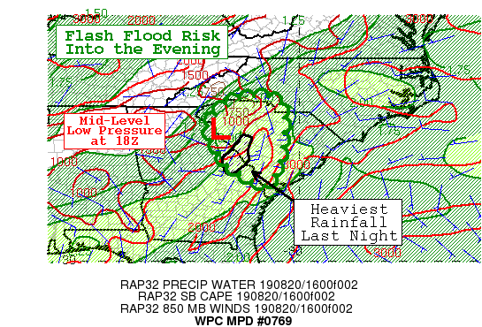
Mesoscale Precipitation Discussion 0769
NWS Weather Prediction Center College Park MD
224 PM EDT Tue Aug 20 2019

Areas affected...Eastern Georgia...South Carolina...into western
North Carolina

Concerning...Heavy rainfall...Flash flooding possible

Valid 201823Z - 210023Z

SUMMARY...Mid-level low pressure on the western side of the
Bermuda High over the South Carolina Piedmont will continue to
provide support to thunderstorm development in a moist and
unstable environment into the evening. Flash flooding is possible.

DISCUSSION...A cyclonic cusp is clearly depicted in the mid-level
(6.95 micron) water vapor imagery from GOES-16 over the SC
Piedmont. Regional radar imagery depicts a swirl pattern in
convective development around and mainly east of this low. MLCAPE
is modest at 1000 to 1500 J/Kg, but the dynamics of the low will
continue to aide lift. PWATs around two inches are 1.5 standard
deviations above normal.

One hour flash flood guidance is generally 1.5 to 2.5 inches.
Rates from KGSP have generally been 1.0 to 1.5 inches over the
past hour, but the slow motion of the low will allow repeating
activity. An area around Augusta, GA had generally 2 to 3 inches
last night which has made that area more vulnerable to further
activity which remains in the convergent inflow to the low.

This risk area will slowly spread north into western NC through
the afternoon hours. Included in the risk area is the broad inflow
area of eastern GA and southern SC where activity will be aligned
with southwesterly deep layer mean flow. The flash flood threat is
considered possible.

Jackson

ATTN...WFO...CAE...CHS...FFC...GSP...

ATTN...RFC...SERFC...

LAT...LON   35258200 35198069 33788055 32478102 32798178
            33218242 33528259 34328296 34838262
Last Updated: 224 PM EDT Tue Aug 20 2019
|


