| WPC Met Watch |
|
|
Mesoscale Precipitation Discussion: #0766 (2020) |
|
(Issued at 947 AM EDT Thu Sep 17 2020
) |
|
| MPD Selection |
|
|
|
|
|

Mesoscale Precipitation Discussion 0766
NWS Weather Prediction Center College Park MD
947 AM EDT Thu Sep 17 2020

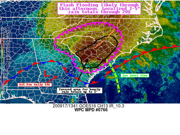
Areas affected...Central to Upstate SC...Western/Central
NC...Eastern GA

Concerning...Heavy rainfall...Flash flooding likely

Valid 171347Z - 171947Z

Summary...Heavy rainfall associated with Sally tracking across
South Carolina into North Carolina will be capable of producing
hourly rain totals 1-2" through mid afternoon. Localized 3-5"
totals are possible and flash flooding is likely to occur.

Discussion...As the center of T.D. Sally tracks across
west-central Georgia this hour, the heavy rainfall axis is
increasingly becoming separated from the center as it interacts
with a stationary front. The combination of southerly flow ahead
of the system off the Gulf and southeasterly flow at 850 mb is
maximizing convergence across portions of central and upstate SC,
where a few recent mesonet observations near Augusta, GA had
2-2.5" hourly totals. The latest mesoanalysis keeps the better
instability gradient generally east of CAE where upwards of 2000
J/kg exists while PWs are broadly in the 2 to 2.4 inch range.

The heavy rainfall will shift from SC into portions of NC (western
to central NC) through this afternoon. The latest hi-res guidance
has a reasonably good agreement and consistency showing hourly
totals up to 2" at times (tied to better instability axis east of
CAE/CLT) while further northwest will have a longer duration event
with hourly totals 1-1.5" at times. The end result is for
widespread 2-4" totals through 20Z with localized 3-5" possible in
any repeating bands. This is supported by the 06Z HREF
probabilities.

The expected intensity and duration of this rainfall will cause
flash flooding, particularly across central SC where the highest
amounts are expected through 20Z. Some of it could significant on
any sensitive or urban locations.

Taylor

ATTN...WFO...CAE...CHS...FFC...GSP...ILM...RAH...RNK...

ATTN...RFC...LMRFC...SERFC...NWC...

LAT...LON   36088057 35887941 35047872 33587949 32568076
            32738205 33728246 34368375 35118343 35788193
Last Updated: 947 AM EDT Thu Sep 17 2020
|


