| WPC Met Watch |
|
|
Mesoscale Precipitation Discussion: #0764 (2020) |
|
(Issued at 1110 PM EDT Wed Sep 16 2020
) |
|
| MPD Selection |
|
|
|
|
|

Mesoscale Precipitation Discussion 0764
NWS Weather Prediction Center College Park MD
1110 PM EDT Wed Sep 16 2020

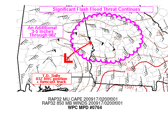
Areas affected...eastern AL into central GA

Concerning...Heavy rainfall...Flash flooding likely

Valid 170309Z - 170800Z

Summary...Slow moving heavy rain ahead of T.D. Sally will shift
the ongoing significant flash flood risk northward from eastern AL
into central GA through 08Z. Rainfall rates of 1-2 in/hr will be
common with localized rates up to 3 in/hr possible.

Discussion...Recently downgraded Tropical Depression Sally
continues to pose a significant flash flood threat to AL and GA
despite some recent increase in forward speed. The 03Z NHC
advisory stated that Sally was located over northwestern Pike
County and was moving toward the northeast at 8 kt. IR satellite
imagery continues to show excellent outflow within the northern
semi-circle of the system. The heaviest rain associated with Sally
was located within a stratiform region roughly 40-50 miles
northeast of the center over Bullock, Barbour and Russel counties
with rainfall rates of 1-2 in/hr common, but rates were locally
higher over northern Barbour County. Heavy rainfall of a more
showery nature was located over central to southern GA, at the
northern end of a curved inflow band emanating from the eastern FL
Panhandle, with the 00Z TLH sounding indicating 2.3 inches of
precipitable water.

The region of heaviest rain, closest to the center of T.D. Sally,
is expected to continue translating northeastward into western GA
tonight, ahead of the center of the tropical depression within a
zone of strong low level moisture flux convergence. Additional
rainfall totals of 3-5 inches can be expected from Russell and
southern Lee counties into western GA. Meanwhile, farther east
into central GA, widespread rainfall totals of 3-5 inches are also
expected as the low level moisture feed from the northeastern Gulf
of Mexico flows into and across a low level baroclinic zone
located over southern GA at 03Z. Given the continued slow movement
of Sally, persistent low level convergence beneath a strongly
diffluent flow regime aloft will continue the threat for heavy
rain with likley flash flooding.

Otto

ATTN...WFO...BMX...FFC...TAE...

ATTN...RFC...SERFC...NWC...

LAT...LON   33868445 33798404 33588333 33228288 32838276
            32478283 32238305 31988344 31758396 31798442
            31848476 31838512 31908527 32088549 32408584
            32668588 32978587 33428555 33728517
Last Updated: 1110 PM EDT Wed Sep 16 2020
|


