| WPC Met Watch |
|
|
Mesoscale Precipitation Discussion: #0686 (2022) |
|
(Issued at 632 PM EDT Fri Aug 05 2022
) |
|
| MPD Selection |
|
|
|
|
|

Mesoscale Precipitation Discussion 0686
NWS Weather Prediction Center College Park MD
632 PM EDT Fri Aug 05 2022

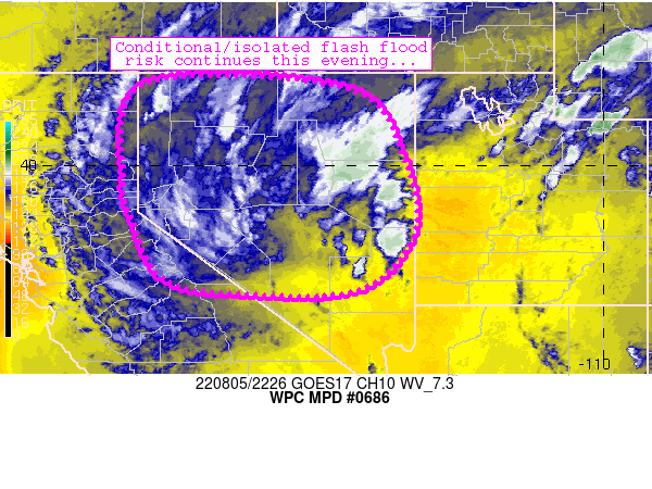
Areas affected...far eastern California, much of Nevada

Concerning...Heavy rainfall...Flash flooding possible

Valid 052230Z - 060430Z

Summary...Areas of showers and thunderstorms continue to pose an
isolated flash flood risk across the western Great Basin this
afternoon and tonight.

Discussion...Showers and a few thunderstorms continue to rotate
around a mid-level low centered over southwestern Nevada this
afternoon.  Widespread cloud debris continues to inhibit deeper
convection except for on an isolated basis where updrafts have
been able to materialize near pockets of better insolation.  Where
these storms have leveraged better instability, a few areas of 1+
inch/hr rain rates have developed, locally exceeding FFGs
thresholds.

Although models/CAMs continue to depict local QPF maxima in
north-central Nevada through the early evening hours, some concern
exists that this scenario may not materialize due to the
widespread cloud cover currently in the area.  An anomalously
moist airmass continues to reside across the area, however, with
PW values exceeding 1.2 inches.  Lingering, yet limited
instability also exists beneath the mid-level low per objective
analyses.  Isolated/localized flash flooding may still occur in
this scenario.

Cook

ATTN...WFO...HNX...LKN...REV...STO...VEF...

ATTN...RFC...CBRFC...CNRFC...NWRFC...NWC...

LAT...LON   41751984 41651550 40221432 38561407 37351523
            37241755 37541943 38912014 39642031
Last Updated: 632 PM EDT Fri Aug 05 2022
|


