| WPC Met Watch |
|
|
Mesoscale Precipitation Discussion: #0663 (2020) |
|
(Issued at 1148 PM EDT Wed Aug 26 2020
) |
|
| MPD Selection |
|
|
|
|
|

Mesoscale Precipitation Discussion 0663
NWS Weather Prediction Center College Park MD
1148 PM EDT Wed Aug 26 2020

Areas affected...Southwest to South-Central Louisiana

Concerning...Heavy rainfall...Flash flooding likely

Valid 270348Z - 270848Z

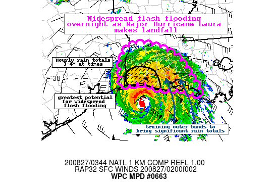
Summary...Major Hurricane Laura is on track to make landfall along
the southwestern Louisiana coast in the next few hours. Intense
rain bands already impacting the coast will spread inland and
bring hourly totals up to 3-4" at times. Through 09Z, isolated
totals of 7-9" and flash flooding, significant in places, is
likely.

Discussion...As of 03Z, the NHC position for Laura is roughly 75
miles south of Lake Charles, LA and KLCH radar imagery currently
shows the initial outer bands of Laura impacting the southern
portions of Cameron and Vermilion Parishes with instantaneous rain
estimates reaching 1.5-2"/hr. GOES-IR imagery shows an impressive
eyewall structure with cooling tops confined to the
northern/northwest quadrant. Blended TPW product depicts
impressive values approaching 3" offshore with 2-2.5" values from
the southeast Texas coast eastward toward New Orleans and inland
to central Louisiana while instability is between 1000-1500 J/kg
along the immediate coast.

There is a strong signal in the latest hi-res guidance for a
several hour period of extreme rain rates approaching 3-5"/hr at
times as the center of Laura makes landfall, supported by the
27.00Z HREF probabilities indicating a 60-80 percent chance of
hourly totals exceeding 3". Similarly, the 02Z WoFS run ensemble
members depict 5-minute rain totals to reach as high as 0.4-0.5"
overnight, suggesting the potential for very extreme and
significant flooding and rapid water rises.

There should be two focus areas for this intense rainfall, one
associated with the eyewall but a secondary feeder band may form
to the east of the center and orient itself north/south along the
mean flow and repeatedly train over portions of south-central
Louisiana in and near Vermilion Bay.

Widespread 5-7" totals are likely along the southwest to
south-central Louisiana coast with isolated 7-9" totals possible
through 09Z. This type of rainfall will result in widespread flash
flooding, particularly along small streams, urban areas, and
roadways will occur overnight into the early morning hours.

Taylor

ATTN...WFO...LCH...LIX...

ATTN...RFC...LMRFC...WGRFC...NWC...

LAT...LON   31009321 30889257 30779232 30559191 30389175
            30209160 30009151 29849140 29639128 29449120
            29279118 29489163 29569214 29599258 29809308
            29769351 29759389 30089386 30409390 30899362
Last Updated: 1148 PM EDT Wed Aug 26 2020
|


