| WPC Met Watch |
|
|
Mesoscale Precipitation Discussion: #0649 (2020) |
|
(Issued at 1045 PM EDT Sun Aug 23 2020
) |
|
| MPD Selection |
|
|
|
|
|

Mesoscale Precipitation Discussion 0649
NWS Weather Prediction Center College Park MD
1045 PM EDT Sun Aug 23 2020

Areas affected...Florida Panhandle Central & Eastern Coast...

Concerning...Heavy rainfall...Flash flooding possible

Valid 240245Z - 240600Z

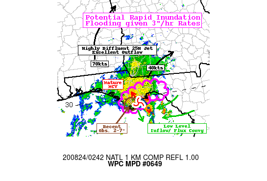
SUMMARY...MCV and Outer Band

DISCUSSION...RADAR mosaic depicts an MCV along the Western
Franklin county coast with an attendant strong eastern side
convergent band.  The MCV has been maintained by favorable latent
heat release but also favorable location to a highly diffluent
entrance region to 50+kt jet.  Observations including WV suite and
AMVs suggest this feature is generally east of the all hi-res CAM
guidance as well as rapid refreshing guidance such as the RAP.
This MCV has responded down to the surface as well, while not a
closed low level circulation per se (using NE Gulf Buoys) a
distinct pressure trof and inverted flow with northerly flow noted
and strong offshore of the peninsula likely to maintain strong
moisture flux convergence.  CIRA LPW suggests the values of 2.25"
are in the vicinity and along with proximity sounding from TBW and
TLH, there is likely amply unstable moist adiabatic environment
with 1500 J/kg of MLCAPE.  Given this strength, angle of
convergence/flux; rain rates in excess of 3"/hr are likely with
shorter sub-hourly rates well above that.

Cell motions within the line are more difficult/dubious as there
will be a tendency to propagate upwind into the strong
convergence, yet the deeply layered flow around the MCV, may help
to support the training band as it lifts and shears into the 7-5H
confluence/deformation shear axis extending north-northeast into
SE GA.  Additionally, thunderstorms and potential for
redevelopment further south into the Northeast Gulf may help to
prolong duration at a narrow portion of the coast from AAF to St.
Marks.  As such pluvial/rapid inundation flooding (though not
likely swift or traditionally perceived flash flooding) is
considered likely where this band sets up with potential of 5+" in
less than 2-3hrs.

The uncertainty remains in how long this feature can manifest
while greater forcing/height-falls are further west with the core
of Marco.  While Hi-Res CAMs are support this trend westward, this
may be a failing of poorer resolution being assimilated to the
guidance.  Still, any westward pull of the MCV/convergent band
would further expand the flash flooding threat, particularly from
Port St. Joe to AAF where 2-7" have fallen today and may further
expand flooding concerns along the Apalachicola River (given less
outwash from increasing onshore flow too).  On this potential have
encompassed it within the MPD area of concern.

Gallina

ATTN...WFO...TAE...

ATTN...RFC...SERFC...NWC...

LAT...LON   30408433 30388381 30228357 29868369 29978419
            29758457 29548493 29568512 29708535 30008535
            30268485
Last Updated: 1045 PM EDT Sun Aug 23 2020
|


