| WPC Met Watch |
|
|
Mesoscale Precipitation Discussion: #0632 (2019) |
|
(Issued at 255 PM EDT Fri Jul 19 2019
) |
|
| MPD Selection |
|
|
|
|
|

Mesoscale Precipitation Discussion 0632
NWS Weather Prediction Center College Park MD
255 PM EDT Fri Jul 19 2019

Areas affected...Western New York, Far Northern Pennsylvania

Concerning...Heavy rainfall...Flash flooding possible

Valid 191853Z - 192230Z

Summary...Thunderstorms will increase in in coverage across
western New York this afternoon, and may produce swaths of heavy
rainfall to around 2 inches in a couple hours. This heavy rain may
lead to flash flooding.

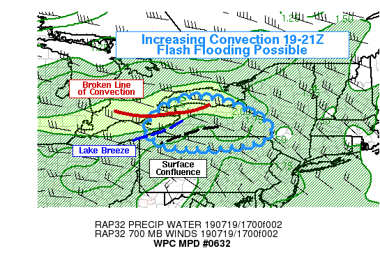
Discussion...As of 19Z, a broken line of convection had developed
from near KROC-KBUF-CYXU, or from far western New York into
southwest Ontario. The storms were moving east but also had a
component of their motion to the south, likely due to some WNW
winds in the mid-levels and the relative location of the strongest
instability. This general motion is expected to continue.
Meanwhile, GOES-16 visible satellite shows some enhanced cumulus
development along the Lake Erie lake breeze, and along a zone of
low-level confluence just south and southwest of the Finger Lakes
region. Additional thunderstorms may develop in these areas and
merge with the ESE propagating convective line. Hi-res model QPFs
only show isolated rainfall maxima in the 18-00Z period. This
seems slightly at odds with the current extent of convection in
the eastern Great Lakes and a strongly unstable air mass with
limited CINH. The merger of the current line of convection with
any upstream development could enhance rainfall in narrow
corridors by prolonging the duration of heavy rain. Given the lack
of hi-res model support and the generally fast forward progression
of thunderstorms, any flash flooding would be likely to be
localized. However, flash flooding will be possible given the
orientation of the ongoing convection close to parallel to the
low-mid level mean flow, and the strongly unstable and moist
environment (PW values around 2 inches; above the 99th percentile
for this region) that will be supportive of heavy rain rates.
3-hour FFG is only around 2 inches in some areas, and if some
storm mergers can occur that seems achievable in some spots in
western New York this afternoon, perhaps extending into the far
northern portions of Pennsylvania.

Lamers

ATTN...WFO...BGM...BUF...CLE...CTP...

ATTN...RFC...MARFC...NERFC...OHRFC...

LAT...LON   43547855 43527749 43297671 42527523 41887546
            41597725 41657927 42258021 43127956
Last Updated: 255 PM EDT Fri Jul 19 2019
|


