| WPC Met Watch |
|
|
Mesoscale Precipitation Discussion: #0628 (2020) |
|
(Issued at 233 PM EDT Thu Aug 13 2020
) |
|
| MPD Selection |
|
|
|
|
|

Mesoscale Precipitation Discussion 0628
NWS Weather Prediction Center College Park MD
233 PM EDT Thu Aug 13 2020

Areas affected...eastern NC

Concerning...Heavy rainfall...Flash flooding possible

Valid 131832Z - 140030Z

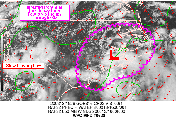
Summary...Training of slow moving convection around a nearly
stationary low will have the potential to produce locally very
heavy rain through early evening. Scattered rainfall totals of 2-4
inches are expected through 00Z, but locally, totals in excess of
5 inches will be possible.

Discussion...18Z visible satellite imagery showed a low level
circulation over the Inner Banks (Pamlico/Beaufort counties) of
eastern NC. Precipitable water via area 12Z RABOs and GPS data
showed values near 2.25 inches across the eastern Carolinas.
Mostly clear skies across inland locations have helped support
MLCAPE estimates at 18Z between 1000-2000 J/kg which supports the
potential for very heavy and efficient rainfall. Although eastern
NC typically is a more difficult region to flash flood, mean storm
motions, according to KMHX radar, were 5-10 kt and near the low
center, nearly stationary.

925 and 850 mb VAD wind and short term data from the RAP showed
10-15 kt of flow to the south and east of the low center, which
has helped support short term training over Craven and Carteret
counties and radar estimates near 2 in/hr given the magnitude of
the low level flow exceeds deeper layer mean wind. RAP forecast
slow to nearly stationary movement of the low through early
evening which will allow additional convection to develop in the
vicinity of the low with potential for peak rainfall rates near 3
in/hr this afternoon. Stronger low level flow to the south and
east of the low and added upper level diffluence (north of upper
ridge centered off of GA coast) will allow for the greatest
potential of training heavy rain from Cape Fear into far eastern
NC, including the Outer Banks. Weak winds throughout the
troposphere will keep the convection disorganized in nature but
1-2 hours of rainfall with rates of 1-2 in/hr, locally higher, may
produce localized storm totals in excess of 5 inches. Localized
flash flood potential will exist across inland locations as well,
but it appears the greatest threat will remain focused south and
east of the low center.

Otto

ATTN...WFO...AKQ...ILM...MHX...RAH...

ATTN...RFC...SERFC...NWC...

LAT...LON   36297687 36297601 35967550 35527536 35177545
            34847571 34427620 34227697 33837747 33927798
            34147830 34927833 35647800 36047760
Last Updated: 233 PM EDT Thu Aug 13 2020
|


