| WPC Met Watch |
|
|
Mesoscale Precipitation Discussion: #0596 (2020) |
|
(Issued at 252 PM EDT Tue Aug 04 2020
) |
|
| MPD Selection |
|
|
|
|
|

Mesoscale Precipitation Discussion 0596
NWS Weather Prediction Center College Park MD
252 PM EDT Tue Aug 04 2020

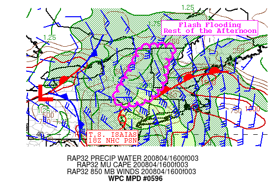
Areas affected...Eastern New York and northwestern New England

Concerning...Heavy rainfall...Flash flooding likely

Valid 041747Z - 042315Z

SUMMARY...Tropical Storm Isaias will continue to shift rapidly
north-northeast from the Delaware Water Gap to Lake Champlain
through this evening. Heavy rainfall will continue ahead of Isaias
across eastern NY and northwestern New England for the rest of the
afternoon and flash flooding is likely.

DISCUSSION...The center of Isaias is estimated to be over the
Delaware Water Gap (northern PA/NJ border) at 18Z, continuing to
accelerate north-northeast east of a closed low over the northern
Great Lakes. A warm conveyor belt is wrapping into the system from
the southeast which is depicted as an axis of scattered showers
that expand in coverage as they reach a warm front draped across
central New England. Deep layer ascent from the right-entrance
region of an upper jet and some instability spreading into the
area ahead of Isaias from southern New England is generally
allowing rainfall rates of up to 1.25"/hr per regional radar
estimates and automated gauge reports.

While these rainfall rates are notably less than earlier today,
the peak rain rates occurring for around 2 hours. This allows
rainfall to approach the 3hr FFG of 2 to 2.5 inches across the
discussion area in about 2 hours. Therefore flash flooding is
likely to continue as the storm tracks through the rest of the
Northeast US through this evening. Areas of terrain including the
Catskills, Adirondacks, and Green Mtns as well as urban areas such
Albany are under the greatest risk for flash flooding.

Jackson

ATTN...WFO...ALY...BGM...BTV...

ATTN...RFC...MARFC...NERFC...NWC...

LAT...LON   45037379 45037201 44387253 43167273 42087361
            41897544 43307479 44617413
Last Updated: 252 PM EDT Tue Aug 04 2020
|


