| WPC Met Watch |
|
|
Mesoscale Precipitation Discussion: #0475 (2020) |
|
(Issued at 343 AM EDT Sun Jul 12 2020
) |
|
| MPD Selection |
|
|
|
|
|

Mesoscale Precipitation Discussion 0475
NWS Weather Prediction Center College Park MD
343 AM EDT Sun Jul 12 2020

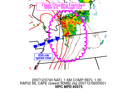
Areas affected...Lower OH Valley into western KY/TN

Concerning...Heavy rainfall...Flash flooding likely

Valid 120740Z - 121230Z

Summary...Heavy rain is expected to produce flash flooding across
portions of the lower OH Valley into western KY and perhaps
western TN over the next few hours. Additional rainfall maxima of
3-5 inches can be expected.

Discussion...Regional radar imagery at 0730Z showed a
southeastward advancing line of convection tracking south across
the IN/KY border, while an axis of nearly stationary convection
was located immediately south in western KY. KPAH and KVWX
rainfall estimates were over 2 in/hr in Union County, KY while
scattered convection was forming just to the northwest of the
cluster in southeastern IL, feeding into the region. Low level
convergence from 20-30 kt of 850 mb flow (KPAH VAD wind plot)
beneath diffluent flow in the upper levels is helping to support
the ongoing convection amid estimated CAPE values in excess of
2000 J/kg just west of the convection.

Short term expectations are for a continued influx of
moist/unstable air into the evolving convective complex with
northwesterly storm motions allowing for repeating and training of
thunderstorms with rainfall rates of 1-2 in/hr but locally in
excess of 2 in/hr. Periods of training are expected to continue
for another 2-3 hours with gradual propagation of the convective
activity toward the south into western TN. Additional storm total
rainfall of 3-5 inches can be expected through 12Z, but some
earlier hi-res guidance was supporting 7-8 inches locally across
western TN which can not be completely ruled out given the
persistent forcing and moisture in place.

Otto

ATTN...WFO...HUN...LMK...MEG...OHX...PAH...

ATTN...RFC...LMRFC...OHRFC...NWC...

LAT...LON   38218749 38098699 37648642 37088623 36268625
            35608645 35248682 35088724 35048788 35248845
            36088897 37378893 38118825
Last Updated: 343 AM EDT Sun Jul 12 2020
|


