| WPC Met Watch |
|
|
Mesoscale Precipitation Discussion: #0458 (2020) |
|
(Issued at 1130 AM EDT Thu Jul 09 2020
) |
|
| MPD Selection |
|
|
|
|
|

Mesoscale Precipitation Discussion 0458
NWS Weather Prediction Center College Park MD
1130 AM EDT Thu Jul 09 2020

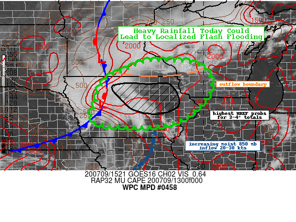
Areas affected...Iowa...Southern Minnesota...Southwestern
Wisconsin

Concerning...Heavy rainfall...Flash flooding possible

Valid 091530Z - 092130Z

Summary...Thunderstorms are expected to increase in coverage
through the afternoon hours and hourly totals up to 2" will be
possible. Localized amounts of 3-4" will be possible and this
could lead to flash flooding.

Discussion...A convectively enhanced shortwave trough moving
across western Iowa this morning along with an approaching cold
front and outflow boundary from the north will be the primary
lifting mechanisms for expanding coverage and intensity of
thunderstorms through the afternoon hours across much of
central/northern Iowa, southern Minnesota, and southwestern
Wisconsin. The current environment is characterized by 1500-2000
J/kg of MUCAPE within an increasing deep moisture axis (12Z DVN PW
of 1.61"). The shortwave will slowly advance eastward and with
increasing insolation/heating any remaining CIN should erode
convection should begin to initiate. The RAP forecast shows the
low level convergence increasing with 850 mb inflow picking up to
around 25-30 kts out of the south, drawing up the deeper moisture
into the region. Convection will have the potential to pivot or
wrap around the MCV, increasing the duration and potential rain
rates of any thunderstorms. The 12Z HREF signal for heavy rainfall
peaks after 17Z with a strong signal (80-90 percent) for 1"+
hourly totals and a moderate (40-60 percent) signal across
central/northeast Iowa for 2"+ hourly totals. The HREF suggests a
40-50 percent of totals through the afternoon exceeding 3", mainly
across central to east-central/northeast Iowa. The local
probability matched-mean QPF is for 2-3" and localized 4" amounts.

The HRRR-driven National Water Model is showing an above normal to
very high streamflow response across the flashier basins of
central to northeast Iowa (and potentially far southwest
Wisconsin) through the afternoon hours. Some flash flooding will
be possible through the afternoon, particularly for sensitive
locations, low-lying, and poor drainage areas.

Taylor

ATTN...WFO...ARX...DMX...DVN...FSD...MKX...MPX...OAX...

ATTN...RFC...MBRFC...NCRFC...NWC...

LAT...LON   44219236 44019023 42928967 41549093 41169270
            41359516 42249504 43249470 43849358
Last Updated: 1130 AM EDT Thu Jul 09 2020
|


