| WPC Met Watch |
|
|
Mesoscale Precipitation Discussion: #0352 (2021) |
|
(Issued at 751 AM EDT Sat Jun 19 2021
) |
|
| MPD Selection |
|
|
|
|
|

Mesoscale Precipitation Discussion 0352
NWS Weather Prediction Center College Park MD
751 AM EDT Sat Jun 19 2021

Areas affected...southern Alabama, western Florida Panhandle,
southeastern Mississippi

Concerning...Heavy rainfall...Flash flooding likely

Valid 191149Z - 191800Z

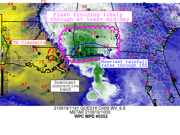
Summary...An axis of focused convergence just east of the center
of TS Claudette will promote areas of flash flooding in the
discussion area (southeastern Mississippi through the Florida
Panhandle) through at least mid-day.

Discussion...Latest observations/mesoanalysis shows an area of
focused low-level convergence across southwestern Alabama and
vicinity coincident with intense convective development.  The
storms themselves are in a very moist/buoyant environment with PW
values of 2.1-2.4 inches and 2000 J/kg MLCAPE values - highest
nearer the coast.  The airmass is promoting extremely efficient
rainfall rates of 2-3.5 inches per hour near the strongest
convection - including within a dominant convective band near
Mobile this morning and with scattered cells ahead of the band
that will move northward into and through the discussion area from
open Gulf waters.  2-4 inch rainfall totals have already been
noted in southeastern Mississippi/southern Alabama - with
localized instances of totals nearing 8 inches since midnight CDT.

Although the specific evolution of convective bands within this
regime is somewhat uncertain, models and observations generally
suggest that the axis of greatest low-level convergence will
gradually shift eastward along the north-central Gulf Coast within
the discussion area through 18Z or so.  With strong buoyancy and
moisture located near/just offshore, intense updrafts and
convective bands will continue to persist in the discussion area,
with highest rainfall rates (exceeding 3 inches per hour at times)
exceeding any flash flood guidance thresholds. Flash flooding is
most likely to occur beneath any heavier bands and/or training
convection that can materialize and persist in the discussion
area.

It is worth noting that additional heavy precipitation may develop
west of the dominant convective band near Mobile Bay through the
afternoon depending on redevelopment of low-level confluence axes
near/east of the cyclone center.  This can foster repeating
convection over areas that received precipitation in western
portions of the discussion area.

Cook

ATTN...WFO...BMX...FFC...JAN...LIX...MOB...TAE...

ATTN...RFC...LMRFC...SERFC...NWC...

LAT...LON   32498667 32448540 32088505 31118503 30168518
            29898534 30048559 30238612 30198703 30038784
            30038868 30208903 31118936 31758940 32198916
            32438819
Last Updated: 751 AM EDT Sat Jun 19 2021
|


