| WPC Met Watch |
|
|
Mesoscale Precipitation Discussion: #0251 (2020) |
|
(Issued at 1257 PM EDT Mon May 25 2020
) |
|
| MPD Selection |
|
|
|
|
|

Mesoscale Precipitation Discussion 0251
NWS Weather Prediction Center College Park MD
1257 PM EDT Mon May 25 2020

Areas affected...The Arklatex

Concerning...Heavy rainfall...Flash flooding possible

Valid 251700Z - 252300Z

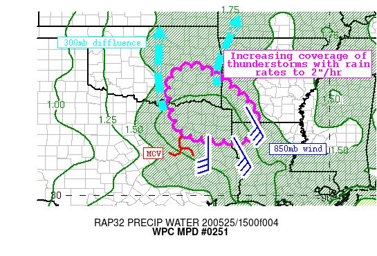
Summary...Developing showers and thunderstorms ahead of an MCV and
in an increasingly favorable environment will become widespread
this afternoon. Rainfall rates may reach 2"/hr at times, with
training to the NW likely. Rainfall of 1-3", with isolated higher
amounts, may lead to flash flooding.

Discussion...Radar mosaic this afternoon depicts a small
circulation associated with a remnant MCV near Waco, TX lifting
northeast. A large area of moderate/heavy stratiform rain was
accompanying this feature to the north and west, while convective
development was noted to the east across Louisiana. A poleward
extending upper level jet streak was beginning to strengthen to
the north evident on GOES-E IR imagery, with some breaks in the
cloud cover becoming evident in the visible. Low-level flow on
regional VWPs was increasing out of the southeast, advecting
copious moisture into the Arklatex as noted by GPS TPW
observations exceeding 1.75" across Louisiana and 1.5" into
Oklahoma.

As the afternoon progresses, the S/SE low-level flow is progged to
increase to 25-35 kts, driving moisture advection northwestward
and PWs may climb towards 2" near the Red River Valley this
evening. At the same time, the upper jet streak should intensify,
placing the RRQ for ascent atop the Arklatex, and overlapping the
nose of the intensifying 850mb LLJ to provide robust synoptic
ascent. Additionally, mass flux and moisture convergence will
maximize as the LLJ impinges upon the weakening and veering wind
field near the MCV center, which combined with rising instability
due to heating where cloud breaks occur will create a favorable
kinematic and thermodynamic environment for convection with heavy
rainfall.

There remains some spread in the CAMs as to where the heaviest
rain will occur, but the ARW, Conest, 15Z-HRRR, and NWM Streamflow
anomalies suggest the higher amounts will occur along and north of
the Red River Valley, just west of the AR/LA borders. Although
mean winds should remain quick, near 30 kts, to drive individual
echoes to the N/NW, training is likely thanks to unidirectional
flow, so some areas may receive several rounds of heavy rain. The
HREF rain rate probabilities show increasing chances for 2"/hr
rates as CAPE recovers and warm cloud depths climb into the
evening, so rainfall of 1-3" with isolated higher amounts is
likely. In some places near the TX/OK border and north, FFG is as
low as 1.5"/1hr and 2"/3hrs due to recent rainfall that has been
150%-300% of normal over the past 14 days. This suggests heavy
rain in these areas could quickly lead to runoff, and flash
flooding will be possible.

Weiss

ATTN...WFO...FWD...LZK...OUN...SHV...TSA...

ATTN...RFC...ABRFC...LMRFC...WGRFC...NWC...

LAT...LON   35309587 35269536 35099502 34999485 34829453
            34499417 34159376 33849342 33539322 33199306
            32869300 32549312 32359347 32329410 32329455
            32429508 32469549 32549587 32729616 33089636
            33529647 33939655 34389661 34829652 35169625
Last Updated: 1257 PM EDT Mon May 25 2020
|


