| WPC Met Watch |
|
|
Mesoscale Precipitation Discussion: #0162 (2019) |
|
(Issued at 827 AM EDT Thu Apr 25 2019
) |
|
| MPD Selection |
|
|
|
|
|

Mesoscale Precipitation Discussion 0162
NWS Weather Prediction Center College Park MD
827 AM EDT Thu Apr 25 2019

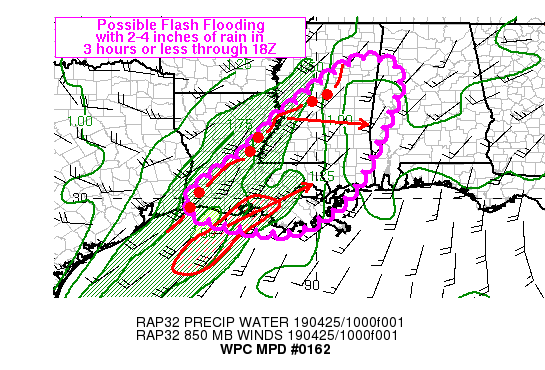
Areas affected...southern/eastern LA into MS and far western AL

Concerning...Heavy rainfall...Flash flooding possible

Valid 251226Z - 251815Z

Summary...Heavy rainfall may allow for flash flooding in a few
locations from southern/eastern LA into MS and far western AL
through 18Z. Favorable alignment of heavy rain cores are expected
to allow 2-4 inches in 3 hours or less time.

Discussion...Regional radar imagery through 12Z across the Lower
Mississippi Valley showed a line of convection with bowing
segments moving across central LA into central MS with a general
movement off toward the east-northeast at 35-45 kt, roughly
aligned with the 850-300 mb mean wind. Dual-pol rainfall estimates
and gauge reports within this line were 1-2 in/hr with training at
times leading to dual-pol estimated rain between 3-4 inches such
as from Madison Parish into west-central MS. 850 mb winds out
ahead of the convective line were SSW at 30-35 kt via the KDGX VAD
wind plot and RAP analyses. A second area of heavy rain was
located out ahead of the convective line, but with less intense
rainfall rates assumed given warmer cloud tops on IR imagery, was
located along and just offshore of the central LA coast.

A positively tilted shortwave trough axis was seen on water vapor
imagery from central AR into south-central TX at 12Z with
forecasts showing the southern portion of the trough axis swinging
out faster than the northern portion allowing for a more neutral
orientation by 18Z. This movement should allow a quicker eastward
progression to ongoing convection across the central Gulf Coast
for the early afternoon.

Until then however, bowing segments along the main convective line
across LA and mS will briefly allow favorable orientation with
respect to the 850-300 mb mean and training of rainfall rates of
1-2 in/hr (locally higher at times). This combined with likely
intensifying rainfall ahead of the convective line given added
diffluence and divergence within the left exit region of a 120-130
kt upper level jet (sampled by 12Z CRP RAOB) will augment updraft
strength and may allow for repeated rounds of heavy rain over the
next few hours from LA into MS. Flash flooding will be possible
with rainfall of 2-4 inches in 3 hours or less which would exceed
Flash Flood Guidance in a few locations.

Otto

ATTN...WFO...BMX...JAN...LCH...LIX...MEG...MOB...

ATTN...RFC...LMRFC...SERFC...

LAT...LON   33948817 33548763 32368796 30328894 29339010
            29069125 29569349 30269341 31329197 32409096
            33798912
Last Updated: 827 AM EDT Thu Apr 25 2019
|


