A cluster of thunderstorms near the mid-level shortwave moved offshore the Mid-Atlantic coast on August 11th and 12th. After
diminishing later on the 12th, thunderstorm activity reformed a few hundred miles southeast of Massachusetts on the 13th. A
surface trough formed near the thunderstorms a few hundred miles north-northeast of Bermuda, with a surface low forming by late
on the 14th about 200 miles north-northeast of Bermuda. Moving south-southeast, thunderstorm activity became better organized.
By the afternoon of the 15th, tropical depression status was achieved about 150 miles northeast of Bermuda. Continuing to move
south to south-southwest, the depression strengthened into Tropical Storm Henri on the afternoon of the 16th about 110 miles
southeast of Bermuda. Henri turned southwest on the 17th around a periphery of a high pressure system to its northwest. Strengthening
was slow due to northerly vertical wind shear. Turning west on the 18th, Henri approached hurricane intensity while sporting
an eye feature before leveling off. Northerly vertical wind shear increased and the related ingestion of dry air led to some
weakening on the 19th. Turning northwest then north on the 20th, wind shear relaxed and Henri became a hurricane late on the
afternoon of the 21st southeast of Cape Hatteras. Accelerating north-northeast, Henri navigated around the southeast side of an
upper low. After crossing the Gulf Stream into colder water, Henri regained tropical storm strength on the 22nd. The storm
made landfall on Block Island and and Westerly, Rhode Island around noon. Slowing and turning west around the upper low, Henri weakened
rapidly over southern New England, becoming a tropical depression that evening over western Connecticut. Henri moved into New York
before doubling back into Connecticut as the main belt of the westerlies turned the cyclone east. Henri became a post-tropical
cyclone on the 23rd before moving east-northeast over Rhode Island and southeast Massachusetts. Henri moved back into the northwest
Atlantic before dissipating later on the 24th.
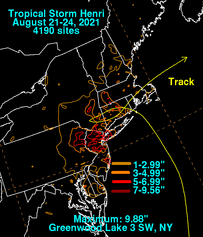
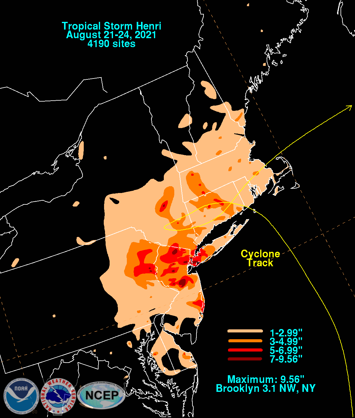
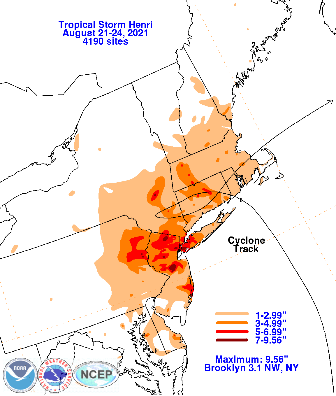
Much of the heavy rainfall with the storm fell within a TROWAL (TRough Of Warm Air aLoft) to the northwest of Henri around the
periphery of the nearby upper low. The heaviest rainfall was concentrated over New York City and portions of northern NJ, including
sections of the middle NJ/NY border. Hourly rain totals peaked at 2.30" at New York City/Central Park on Aug 21 between 10:12 pm-
11:12pm EDT, which was their wettest hour since August 10, 2006 (over 15 years). The graphics below show the storm total rainfall for
Henri, which used rain gage information from the National Weather Service River Forecast Centers, Forecast Offices, and CoCoRAHS.
 |
 |
 |