Late Twentieth Century
| August 13, 1953 (Barbara): Early on the 11th, a tropical
storm was discovered in the southeastern Bahamas. It became a hurricane
northeast of the Bahamas on the 11th and gained intensity as
it moved north. At 10 p.m. on the 13th, it struck the North
Carolina coast between Morehead City and Ocracoke (track to the right).
The storm then moved north and northeast, before going out to sea just
south of Norfolk.
Winds reached 63 mph with gusts to 76 mph at Norfolk. Winds at Cape
Henry were sustained at 72 mph. Cape Henry lighthouse saw its copper canopy
torn loose during the cyclone. Rainfall amounts of five to eight inches
were common across southeast Virginia. Portsmouth saw 9.3" of rain deluge
the city in only 24 hours. |
 |
August 25-31, 1954 (Carol): Hurricane Carol, a major hurricane
when it made landfall in North Carolina, moved northward into New England
(track above and below). It moved 100 miles off the Virginia Capes and
brought winds of 40 mph to Virginia Beach. Norfolk received four inches
of rain. Chincoteague reported the lowest pressure...29.28". The system
helped ease drought conditions in Washington, D.C..
|
October 15, 1954 (Hazel): On the 4th, a tropical
storm moved through the Windward Islands into the Caribbean Sea. It quickly
formed into a hurricane and continued on a westerly track until the 10th.
An upper low in the western Caribbean steered Hazel northward through the
Mona Passage on the 12th. As the hurricane did so, heavy rains
caused mudslides in Haiti which killed 500 people. Its track became northwesterly
as a cold front approached from the Mississippi Valley. The hurricane then
accelerated into northeast South Carolina as a category four hurricane.
On the 15th, it passed over Raleigh, Richmond, and West Virginia
(track to the left).
One of the most severe storms to ever strike the Eastern seaboard caused
destruction at beach resorts. Pressures fell to 28.67" at Virginia Beach,
28.75" at Richmond, and 28.99" at Norfolk. Trees, power lines, and radio
towers were downed. Power failure was common across the region...in some
areas, for as long as 48 hours. |
Considerable damage was done to residential and business property in
Washington as sustained winds peaked at 78 mph with gusts to 98 mph. At
National Airport, a light plane flipped over and part of the hangar was
blown away. The Weather Bureau radar had to be turned off for three hours
when the motor began to heat up. As a cold front interacted with Hazel,
a squall line swept through Washington, D.C. at 6:15 p.m., dropping the
temperature 20 degrees in one hour. Frost was seen in the suburbs the following
night.
Hundreds of trees fell across the Federal City. Many store front windows
shattered. Falling trees damaged many houses in Fairfax. Winds whipped
up white caps on the Potomac. Waters overflowed the seawall at Hains Point.
Alexandria saw the Potomac flood reclaim two blocks of the city, flooding
basements and first floors of businesses. U.S. 1 was flooding by 9 p.m.
at Hunting Creek. Heavy rains fell in the mountains, with a couple locations
measuring over 10 inches.
Norfolk's sustained winds reached at 78 mph with gusts to 100 mph. Hampton
saw winds as high as 130 mph. Damage was extensive from strong winds and
high tides. Several ships in the James River were sunk or wrecked. At the
Old Dominion Boat Club in Alexandria, two cruisers sank and several docks
washed away. Quantico saw most of its docks vanish. Fourteen sailboats
met an untimely fate at the Washington Sailing Marina. Tides reached 8.7
feet above low water datum at Washington, D.C..
The battleship Kentucky broke its moorings and ran aground 100
feet away. The gun screw vessel Pirate was lost off West Norfolk.
The Coast Guard beacon light on the Potomac at Morgantown was toppled by
Hazel's winds. Thirteen across Virginia perished...2 in the District of
Columbia ...damage estimates reached $15 million.
| August 12, 1955 (Connie): Connie developed in the tropical
middle Atlantic on the 4th, and moved west northwest to the
north of Puerto Rico. Motion slowed on the 9th, as Connie began
to interact with the developing Hurricane Diane. On the 11th,
the system accelerated north- northeast and hit Cape Lookout, North Carolina
(track to the right). It crossed the coast near Norfolk, emerging back
into the Atlantic. Heavy rains and high winds were seen from North Carolina
northward into New England.
Winds picked up on the upper Chesapeake Bay at 4 a.m., reaching gale
force by daylight. The Levi J. Marvel was fighting the storm. When
winds reached 50 mph, the canvas sails tore away. Twenty to twenty-five
foot swells tormented the ship near Holland Point and it broke anchor.
She took on water and capsized around 2:40 p.m.. Eleven drowned. The oil
screw La Forest L. Simmons capsized 1 ½ miles north of Sharps
Island Light in Maryland.
|
 |
Norfolk's pressure fell to 28.77". The highest wind gusts were seen
at Chincoteague, where winds peaked at 64 mph. National Airport at Washington
D.C. reported sustained winds of 49 mph, with gusts to 58 mph, and 4.57"
of rain. Power lines went down around the District. Scores of trees fell.
Dozens of basements were flooded by the heavy rains. Eastern Virginia saw
eight to ten inches of rain with Connie. Due to a drought which preceded
the storm, any flooding was of minor consequence. Tides peaked at 6.6 feet
above low water datum at Washington, D.C.. Four died in Rock Creek during
the storm.
|
August 17-18, 1955 (Diane): The category one hurricane named
Diane caused heavy rains, compounding the flooding caused by Connie not
even a week earlier. As Connie moved out to the north, Diane followed the
storm and also struck North Carolina (track to the left). It passed west
of Danville at 6 p.m.. The lowest pressure seen across Virginia was 29.48"
at Lynchburg. Winds gusted to gale force across eastern Virginia and Washington
D.C.. Winds peaked at 45 mph at Chincoteague. In the tidewater of Washington
D.C., tide were four feet above normal... the peak level was 7.1 feet above
mean lower low water on the morning of the 18th. Persistent
east and southeast winds over the Chesapeake led to this condition.
The heaviest rain fell across northern Virginia, where amounts totaled
over six inches. Several locations on the eastern slope of the Blue Ridge
mountains recorded over a foot of rain. Flood stages were reached at most
points in the Potomac Basin. Tides peaked at 7.0 feet above low water datum
at Washington, D.C.. However, the heaviest flooding occurred along portions
of the Shenandoah River Basin. High tides were also experienced, in addition
to the rains. Damage in Virginia totaled $10.7 million. This hurricane
produced over $686 million in damage, mainly due to its disastrous floods
across the East Coast. |
September 19-20, 1955 (Ione): Ione was a major hurricane as it
approached the Mid-Atlantic. Originally expected to move through
Washington, D.C., the storm veered off to the right, proving to be far
less of a menace than anticipated (track above). Sustained winds
at Norfolk peaked at 47 mph with gusts to 58 mph. The pressure bottomed
out at 29.13" (986 hPa). Total rainfall from the hurricane was 3.5".
This cyclone gave a scare to the Mid-Atlantic, before it veered out to
sea.
September 27, 1956 (Flossy): This hurricane formed in the Gulf
of Mexico and left a path of destruction from the Mouth of the Mississippi
river through the Florida panhandle, Georgia, and South Carolina. As a
nontropical gale, the system alleviated drought conditions across the region.
Shortly after midnight, winds peaked at 45 mph in Washington, D.C.. One
thousand phones were dead due to disabled phone lines. Three inches of
rain fell across Virginia. Some streets in Norfolk were flooded with 2
½ feet of water (Barnes II). The Back River lighthouse collapsed
during the storm. The gas screw vessel Mary Anne was lost at Hampton
Roads Naval Base.
| September 27, 1958 (Helene): Maximum sustained winds
at Norfolk peaked at 41 mph with gusts to 56 mph as this hurricane moved
by to the southeast. |
 |
July 1959 (Cindy): Winds at Norfolk peaked at 45 mph with gusts
to 46 mph. Small yet violent tornadoes were spawned by Cindy in Norfolk
and Portsmouth. Over four inches of rain fell in Hopewell.
September 30, 1959 (Gracie): This tropical cyclone initially
struck the Atlantic coast south of Charleston, and moved west of Charlotte
into western Virginia (track above). A tornado (one of three) touched down
eight miles west of Charlottesville, killing 11. Heavy rains were seen
in the Appalachians and near Norfolk. Norfolk saw 6.79" of rain in twenty-four
hours. In all, twelve perished.
 |
September 11-12, 1960 (Donna): From the beginning, Donna
was a ferocious storm. On August 29th, squalls in the vicinity
of Dakar, in the country of Senegal on the west coast of Africa, forced
the crash of an airliner, killing 63 aboard. The system moved out in the
Cape Verde Islands on the 30th, and arrived at the Leeward Islands
on the 4th. Amazing flash flooding was seen across the Virgin
Islands and eastern Puerto Rico, when up to 15 inches of rain fell in less
than four hours. Winds gusted to 180 mph across the Florida Keys, as the
hurricane turned northward.
Thereafter, Hurricane Donna affected the entire length of the Atlantic
coast of the United States. Donna became the first hurricane since complete
records were kept in 1871 which traversed the Florida peninsula, the southeastern
Unites States, the Mid-Atlantic region and New England.Donna made a second
landfall between Wilmington and Morehead City on the evening of the 11th
as a category three hurricane. The system tracked across the Albemarle
and Pamlico sounds of North Carolina and re-emerged into the Atlantic Ocean
just southeast of Virginia Beach shortly after 5:00 AM September 12, 1960.
Above is a list of the lowest pressure measured in the region during Donna. |
Virginia Beach saw the pressure fall to 28.51"...and winds gusted to
89 mph. Maximum sustained winds reached 73 mph at Norfolk and 80 mph at
Cape Henry. The Chesapeake lightship estimated 138 mph winds as the pressure
dove to 28.65". Eastern Virginia saw the most rain...where six to eight
inches fell. The vessels Peggy and Tender were wrecked off
Norfolk. Three died in Virginia due to Donna.
August 29-September 1, 1964 (Cleo): This hurricane passed through
the inland sections of the state from west to east. Washington, D.C. could
only watch it rain to the south, as record drought plagued the area throughout
much of the summer and fall. Southern sections of the Old Dominion saw
inundating rains. In Tidewater Virginia, ten to fourteen inches of rain
fell in about 12 hours. Two perished...both deaths were caused by motorists,
who after being stranded in flood waters, were poisoned by carbon monoxide.
Damages totaled $3 million.
September 11-14, 1964 (Dora): As Dora moved northeast from Cape
Hatteras out to sea 120 miles southeast of Norfolk, its influence was felt
across southeast Virginia. Tides of three feet above normal in Hampton
Roads caused moderate flooding of low lying areas. Heavy rain led to flooding
at Suffolk and Yorktown. The heaviest rain was seen at Diamond Springs,
5.83 inches. Norfolk saw winds peak at 63 mph, causing minor damage. Near
Cape Henry, a large freighter was driven aground.
September 9-11 & 15-18, 1967 (Doria): An extreme example
of how erratic a path of a hurricane can be, it remained near the southeast
coast of the United States for 13 days, moving different directions every
few days. As a hurricane on the 13th, it moved westward. The
storm made landfall near the Virginia Capes before meandering south for
a brief skirmish with North Carolina on the 17th, then eastward
back out to sea.
Two periods of rain were associated with Doria in Virginia. The highest
amount recorded was 4.66" at Lake Drummond, near Wallaceton. As the storm
passed offshore the Virginia Capes by 225 miles on the 10th
and 11th, winds gusted to a mere 36 mph at Norfolk. Cool air
invaded the Mid-Atlantic. Washington, D.C.'s temperature fell to 49 degrees
on the 11th.
The second approach on the 15th and 16th caused
winds to gust to 55 mph...the pressure fell to 29.60" at Norfolk. Gusts
to 60 mph were seen at Wallops Island on the 16th. Torrential
rains and squalls buffeted the Eastern Shore. Winds damaged trees, roofs,
signs, and billboards. Twenty to thrity foot seas came in advance of Doria's
second coming towards Virginia. The superstructure of a 38-foot boat was
torn off by high seas off the Atlantic coast near the Virginia/Maryland
border...three perished from the vessel (Bailey). Tides were four feet
above normal at Virginia Beach.
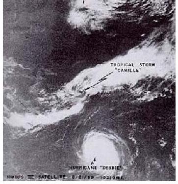
| August 19-20, 1969 (Camille): One of the strongest hurricanes
ever recorded, Camille became Virginia's worst natural disaster ever. Camille
weakened as it moved through the Southeast...until reaching the Appalachian
mountains. As a cold front approached from the northwest, a burst of heavy
rains developed across southeast West Virginia and western Virginia.
To the right is a NIMBUS III satellite image of Camille just offshore the
Mid-Atlantic on the 21st, provided by NCDC.
A band of rain and thunderstorms about 45 miles wide stretched from
White Sulphur Springs, West Virginia to Fredericksburg. Rainfall increased
rapidly along the west slopes of the Blue Ridge mountains; more than ten
inches fell at Clifton Forge. In Nelson county, one location reported a
whopping 27" of rain in only eight hours. This caused 133 bridges to be
wiped out throughout Nelson county, making transportation nearly impossible.
As Camille intensified back into a tropical storm over Virginia, four inches
of rain fell along the coastal plain, in the path of the redeveloping storm. |
 |
When the rains began in earnest, telephone lines were downed, preventing
the true nature of the flooding to the known until much later. Extensive
flash flooding and landslides caused a major disaster on the Tye and Rockfish
river basins. Landslides swept into hollows, destroying roads, homes, bridges,
and railroads. Charlottesville was isolated as rock and mud slides blocked
roads.
The James river experienced a flood of record as far downstream as Richmond.
To the right is a table of values for different locations withing the James
River system. Buena Vista had 5 ½ feet of water in its business
district. Glasgow, at the confluence of the Maury and James rivers, saw
its entire business district destroyed by water nearly 14 feet deep. Flash
flooding caused 153 people to perish, mainly across Virginia. The oil screw
Leader
foundered
four miles east of Cape Henry. Damage totaled $113 million.
The following are river records set during Camille:
| Location |
River Stage |
| Buena Vista |
30.5 feet |
| Scottsville |
31.5 feet |
| Bremo Bluff |
39.1 feet |
| Palmyra |
39.85 feet |
| Cartersville |
33.75 feet |
| Columbia |
41.3 feet |
| Westham |
24.8 feet |
May 26-27, 1970 (Alma): On the subsident side of the cyclone,
at 1:15 p.m. on the 27th, a strong dust devil at Radford picked
up a roof of a school hallway and dumped it onto the school grounds, injuring
six.
August 27, 1971 (A second Doria): A weak tropical depression
formed in the eastern Atlantic and moved swiftly to the west, passing through
the northern Leeward Islands on the 23rd, and moving just to
the east of the Bahamas on the 25th. While recurving to the
north, Doria became a tropical storm and continued to intensify as it approached
the coast. Maximum sustained winds were 65 mph with the system as it made
landfall in North Carolina (see track below).
Maximum sustained winds were 52 mph at Norfolk, 59 mph at Wallops Island,
and 60 mph at Langley Air Force Base. A large warehouse near the Norfolk
airport experienced severe damage. Appreciable losses were caused by a
tornado as it tracked through Portsmouth and Chesapeake. Hundreds of trees
fell and a dozen homes were damaged.
The highest rainfall amount was 6.44" two miles south-southeast of Halifax.
Four-Mile Run flooded once more. A sewage plant in Virginia Beach became
clogged with silt and sand. When the sewage was dumped into the Chesapeake,
beaches were closed for days. A young girl drowned in Alexandria, when
she fell into a drainage ditch.
| September 30-October 3, 1971 (Ginger): Tracked for 31
days as a cyclone through the Subtropical Atlantic, the very long-lived
Ginger tormented Bermuda twice before moving west into North Carolina near
Atlantic Beach. Maximum winds were under 50 mph across southern Virginia.
Norfolk gusted to 49 mph from the northeast on the 30th. A few
trees were leveled with isolated utility outages leading to minor inconvenience.
The heaviest rains from the decaying tropical storm were seen in southeast
Virginia. Diamond Springs reported a 7.49" deluge of rain. Tides ranged
from two to four feet above normal. Moderate to heavy beach erosion ate
away at Virginia Beach. |
 |
June 21-22, 1972 (Agnes): Developing near the Yucatan peninsula
of Mexico on the 15th, Agnes turned north and on the 16th
attained hurricane status in the east-central Gulf of Mexico. A category
one hurricane when it struck the Florida panhandle on the 17th,
the storm weakened as it moved up the coast, east of the Appalachians.
Pressures fell to 29.10" at Norfolk. Langley Air Force Base experienced
wind gusts to 54 mph.
Big Meadows totaled 13.6" of rain from the decaying storm. The highest
amount measured was 16" at Chantilly (See rainfall map to the upper right).
An all-time 24 hour precipitation was set at Dulles Airport, when 11.88"
deluged the area (Kocin). Associated severe flooding caused record river
stages along the east half of the James river basin. Floods of record were
recorded at Cartersville (37.87 ft.), the Richmond City Locks (36.5 ft.),
and Richmond near Westham (28.62 ft.). This flood caused the James to swamp
a 200 block area of downtown Richmond, the worst flooding since May 1771.
Only one of the five bridges across the James was left usable. Moderate
flooding occurred at Buena Vista.
Near Alexandria, Four Mile Run flooded the heavily populated section
of Arlandria. Flooding was also severe along the Appomattox River Basin.
The entire Potomac also flooded. Along the Potomac, 66 miles of towpath
were scoured by the floods. Inundation led to a 300- foot cave-in at the
Widewater section of the C & O Canal. Thousands of homes were flooded
in Washington, D.C.. Even the White House experienced the wrath of Agnes,
when heavy rains invaded its basement. Around 49,000 phones were put out
of commission by downed lines. In the D.C. metropolitan area, ten people
fell victim.
One hundred three highways were either destroyed or damaged across the
state. The shellfish and oyster industry suffered due to excessive fresh
water runoff into the Chesapeake destroying their marine habitat for weeks.
Damage done across the state from Agnes totaled $222 million....$25 million
in Fairfax county alone. The C & O Canal saw $34 million in damages.
Thirteen died from flash flooding in Virginia.
As the storm moved northeast through New York, destructive floods and
tornadoes surged the damage total to over $2.3 billion for the United States.
The worst floods on record were experienced across Pennsylvania and southern
New York, as over sixteen inches of rain fell in several locations.
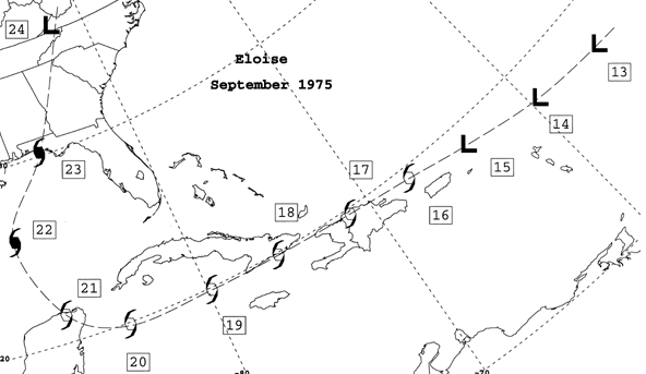 |
| September 24-26, 1975 (Eloise): After striking the Florida panhandle
as a major hurricane, Eloise accelerated inland and was downgraded to a
tropical storm in Alabama (track above). Heavy rains began to fall across
the Mid-Atlantic as Eloise interacted with a cold front. Street flooding
was rampant in Virginia and Washington D.C.. The 9.08" of rain seen at
Washington, D.C. from the cyclone led to the wettest September at the site
since 1934. Flooding was experienced along the Patuxent River and Four-Mile
Run. Arlandria experienced such a flood that 400 residents evacuated during
the night of the 25/26th ($11.9 million).
Forty residences were submerged near Manassas, on Bull Run. Rock Creek
Parkway was closed due to mud slides. Nearly 300 secondary and thirteen
primary roads were closed due to the flooding statewide. Damage totaled
$17.2 million |
August 9, 1976 (Belle): A tropical wave moved offshore Africa
on July 28th and moved uneventfully across the Atlantic and
Caribbean Sea. A tropical depression formed on the north end of this wave
on the 6th, in the vicinity of the northern Bahamas. Belle rapidly developed
into a hurricane on the 7th. On the 8th, the system
accelerated northeast and it made its closest approach to North Carolina
on the 9th. It passed 85 miles east of Norfolk at 1 p.m. EST.
Later that day, the fast moving storm made landfall on the coast of western
Long Island.
Although on the weak west side of this hurricane, Virginia noted the
passing of Belle. Pressures fell to 29.44" at Wallops Island...where winds
of 60 mph were seen in gusts. Over four inches of rain fell along the immediate
coast of Virginia. At South Island along the CBBT, winds peaked at 63 mph.
One died in a related traffic accident in Norfolk.
September 5, 1979 (David): David was a classic Cape Verde hurricane
which caused massive destruction along its path across the western Atlantic.
Dominica was the first island to experience David. Almost three-fourths
of the population was left homeless by the cyclone. It was their strongest
hurricane since 1834. As it moved westward across Puerto Rico, $70 million
in damages was exacted from the island. Haiti was devastated the most by
the borderline category 5 hurricane when heavy rains, mud slides, and high
winds led to over 1,200 lost lives. Entire villages were swept away be
the epic flood; the tempest caused $1 billion in damage across Hispaniola.
As the menacing storm continued its parabolic course, a brief landfall
occurred at West Palm Beach. Now moving northward, the system moved just
inland of the Atlantic Seaboard after its final landfall near Hilton Head,
SC. When squalls passed through Virginia on the 5th, two powerful
tornadoes tracked through Newport News and Hampton, causing $2.5 million
in damage.
Most damage across the area was produced by gusty winds, as high as
60 mph. Trees and power lines were no match for David; this led to 140,000
people without power. A tornado touched down at the edge of Fairfax City
at 7:22 p.m. on the 5th, severely damaging 22 homes ($2 million
damage). This tornado lifted briefly, before touching back down at Great
Falls. Eight tornadoes touched down from Fairfax and Loudon counties south
to Newport News.
Many funnel clouds and weak tornadoes played havoc with Washington,
D.C.. Winds only gusted to 39 m.p.h at National Airport; rains at that
location totaled 3.68". Flooding was seen along Rock Creek, leading to
the road's undermining ($374,000 damage). Floods also invaded the Alexandria
waterfront. Heavy rains fell across the mountains of western Virginia and
also in the vicinity of Norfolk. Big Meadows recorded 8.93" on the 9th
while nine inches fell at Poor Mountain, near Roanoke. Flooding began around
9 p.m., inundating Colonial Heights- Petersburg, Rappahannock, Page, Madison,
and Orange counties. Three perished in the storm. Total insured losses
to the D.C. metropolitan area reached $8 million.
July 25, 1985 (Bob): A tropical depression formed in the southeast
Gulf of Mexico. It slowly meandered east, becoming a tropical storm just
prior to making landfall across southwest Florida. As the system reached
the east coast, it turned to the north. Hurricane status was achieved to
the east of Georgia. The cyclone moved north into South Carolina, weakening
quickly back into a tropical depression.
As the low moved north through Virginia, Bob spawned two weak tornadoes
of F0 intensity and one strong tornado of F3 intensity. The two weak
tornadoes near Richmond and Charlottesville damaged ten houses. The
strongest tornado in northern Albermarle country destroyed two homes.
Funnel clouds were observed throughout the Washington, D.C. metropolitan
area. Gusty winds downed power lines, disrupting the Boy Scout jamboree
in Fredericksburg. Winds peaking at 48 mph at National Airport downed a
seaplane in the Washington Channel, near Hains Point, shortly before 2
p.m..
High winds and heavy rains damaged trees and led to a loss of power
to 30,000 throughout the D.C. suburbs of Virginia and Maryland. A house
under construction in Great Falls collapsed. Two people were fatally injured
in Germantown, MD when a car slid into another vehicle while attempting
to enter a curve. In the District, a man perished when his van struck
an eastbound car. At 2 p.m., a car accident claimed a life near Calverton,
MD.
 |
September 27, 1985 (Gloria): For ten days, this system gained
intensity as it moved across the Atlantic, becoming an extremely dangerous
and large category four hurricane east of the Bahamas (track to the left).
As the storm accelerated north, cooler water temperatures caused weakening
of the once powerful hurricane. Still, Gloria moved over Cape Hatteras
at 2 a.m., where a pressure of 27.98" was achieved.
Virginia Beach saw the pressure bottom out at 28.87". Norfolk experienced
winds sustained at 46 mph, with gusts to 67 mph. Norfolk Naval Air Station
reported wind gusts of 64 mph. Sustained winds of 94 mph, with gusts to
104 mph, blew through South Island's Chesapeake Bay Bridge Tunnel (CBBT). |
Hampton Roads saw a 5.65" deluge of rain. Southeast Virginia measured
the most rain; isolated locales saw over eight inches. The highest tide
noted was 5.3 feet above mean lower low water. Damage totaled $5.5 million
statewide. This storm became nontropical in Canada and continued to rapidly
move east. A record warm spell greeted Europe as Gloria made landfall on
the continent early in October.
November 2-7, 1985 (Juan/"Killer Flood of 1985"): This hurricane
of non-tropical origin drifted aimlessly across Louisiana during the last
week of October before moving east into Pensacola on Halloween.
As the center of Juan moved north towards Michigan, a secondary low moved
east across North Carolina, continuing the moderate rains. A third
low pressure system, along Juan's cold front, transformed a minor flood
into a major disaster. A massive rain shield developed as warm, tropical
air overrode cooler air to the north of the center. This third system
tracked across southwest Virginia on the 4th, and eventually through northern
Virginia and Maryland.
Heavy rains fell across the eastern slopes of the Blue Ridge mountains...19.77"
two miles northeast of Montebello. The Bloomington Reservoir rose 80 feet
in a mere 30 hours. It was considered more damaging, further upriver than
Agnes was in 1972. Record-breaking flood discharges occurred at many
locations within the Potomac, James, and Roanoke river basins (Carpenter).
The heart of the destruction was across Virginia and West Virginia. In
Virginia, 3500 homes were destroyed. Carpeting, dead animals, window frames,
and numerous household items began flowing down the Potomac.
The most extensive damage in the Old Dominion occurred in the Roanoke river
basin, in the Roanoke-Salem metropolitan area. Many in Roanoke were
rescued from rooftops via boats and helicopters. Waters rose to the
third story of an apartment complex in Salem. Lynchburg experienced
the James rising to seven feet above the previous record, set in 1877.
Stored tobacco was in ruin; losses totaled $8 million. Extensive
flooding invaded Richmond. Monetary losses exceeded those of Camille
and Agnes. Forty counties and twelve independent cities were declared
Federal disaster areas.
Waters rose to within two inches of the top stones of Georgetown's Lock
3, stopping just shy of a catastrophe for Washington, D.C.. Waters were
high for four days. Total damages along the C & O Canal from Cumberland
to Georgetown was over $9 million. Overall, the Potomac saw $113 million
in damages. In Virginia, 22 perished and $753 million of damage was incurred.
In West Virginia, almost 2600 residents were left homeless after the floods,
and damages skyrocketed to $500 million. It was the worst flood in
West Virginia history as several small towns were almost destroyed (Stanton).
Total damage across West Virginia, Virginia, Pennsylvania, and Maryland
totaled $1.4 billion.
August 17, 1986 (Charley): Forming as a tropical depression over
the northeast Gulf of Mexico, the system wandered east and northeast to
off the South Carolina coast before finally becoming a tropical storm.
(track above and below). Charley briefly became a hurricane immediately
off the Mid Atlantic coast. Norfolk saw winds of 40 mph, gusting to 63
mph. Cape Henry experienced sustained winds of 54 mph with gusts to 82
mph. South Island's CBBT saw hurricane conditions as 94 mph sustained winds,
with gusts to 104 mph, lashed the station.
A light twin engine plane crashed into the Chesapeake Bay at around
7 p.m., killing all three aboard. Tides rose to 5.5 feet above mean lower
low water. Damage totaled less than $1 million statewide.
September 21-22, 1989 (Hugo): Hugo was a well organized tropical
disturbance as it emerged off the coast of Africa. It developed modestly
as it crossed the ocean and became a category five hurricane as it approached
the northeastern Caribbean Sea. Puerto Rico took its toll on Hugo (and
vice versa) and Hugo weakened into a minor hurricane. Over the next few
days, the system re-attained hurricane status and strengthened rapidly
in the hours before landfall near Charleston. The track of Hugo then took
a northward turn, across western Virginia, before transitioning into a
nontropical low (track to the upper right, satellite picture to the upper
left provided by NCDC). Winds peaked at 37 mph at National Airport.
The low pressure system later merged with a cold front. Six died in Virginia
due to Hugo.
October 11-13, 1990 (Klaus & Marco): Klaus, once a hurricane
northeast of the Caribbean, moved west-northwest to the north of the Greater
Antilles as a weakening, sheared tropical storm. At this time, Marco was
forming in the Florida Straits. The two low pressure systems moved in tandem
on opposite sides of the Florida peninsula. The remains of Klaus came ashore
along the east coast, accelerating northward into the Appalachians. Meanwhile,
Marco limped ashore the Florida panhandle and moved slowly northeast. The
combination of these two systems dropped around eight inches of rain to
the mountains of western Virginia.
August 17-18, 1994 (Beryl): This tropical storm formed very close
to the Florida panhandle on the 14th. Landfall took place near
Panama City at 8 p.m. EST on the 15th. Thereafter, the cyclone
weakened to a tropical depression and moved northeast. Around five inches
of rain fell across western Virginia. Heavy rains spread northeast to New
York state. One tornado touched down just north of Ridgeway and tracked
4 1/4 miles. One hundred homes and thirty businesses were damaged along
its path, and ten people were injured ($8.7 million).
Seven inches of rain fell in Carrol and Grayson counties, flooding roads
and low bridges. Flood waters on Kerrs Creek sent one family evacuating.
Evacuations also took place near the New River in Pulaski county. Roads
in western Augusta county were closed. Faquier county saw mud and gravel
slides damage and close roads. Over twenty roads were flooded in Shenandoah
county. Winchester was inundated in a foot and a half of standing water.
Damages totaled $15 million statewide.
August 6-7, 1995 (Erin): The remains of Erin spread eastward
from the Ohio Valley across West Virginia, northern Virginia, and Maryland.
Almost six inches of rain fell in some areas of extreme northwest Virginia.
It caused brief relief from an otherwise excessively hot and dry July,
August, and early September. A tornado was spawned near the Patuxent Naval
Research Center.
 |
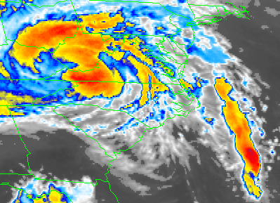
October 5, 1995 (Opal): After accelerating northward out of
the Gulf of Mexico, Opal moved quickly through the Eastern United States.
The satellite picture to the left was taken as the cyclone was accelerating
through northwest Gerogia at 4 a.m. on the 5th, provided by NCDC.
Despite hundreds of miles of travel from the Gulf of Mexico, gale force
winds blew through western Virginia. Winds sustained at 40 mph, with gusts
past 60 mph, blew down trees mainly above 2000 feet elevation in the Shenandoah
Valley and along the Allegheny Plateau. Dozens of trees were blown down
along Skyline Drive in Page and Warren counties.
In Waynesboro, a canopy over a service station was ripped off. South
Winchester and Elkton saw 2600 homes and businesses without power as lines
were downed by the winds. Two tornadoes struck the tidewater. One touched
down at West Point airport in New Kent county. It tore the roof off a hangar,
destroying a small airplane and damaging four others. The second tornado
uprooted trees and damaged outhouses.
In Madison county, five inches of rain fell on Graves Mountain, washing
out a bridge previously destroyed by floods that June. A minor mudslide
occurred in Grayson county. A vehicle was swept off the road by flood waters
six miles southwest of Fancy Gap in Carroll county. Washington, D.C. saw
local street flooding from the system's rainfall. Four to eight inches
of rain fell across southwestern Virginia. This helped end drought conditions
brought on from a very dry July, August, and September. Damage totaled
$220,000. |
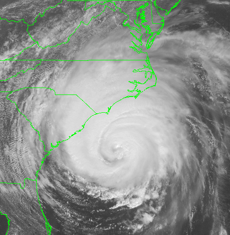
| July 12-13, 1996 (Bertha): The earliest Cape Verde hurricane
ever witnessed to cross the Atlantic unscathed, unprecedented Bertha lashed
the Mid Atlantic coast (track below). To the right is an image of the hurricane
as it was making landfall in North Carolina, provided by the National Climatic
Data Center (NCDC). Portsmouth reported winds gusting to 54 mph on
the 13th... the pressure fell to 29.37". Tree limbs falling
on power lines caused temporary power outages. Over four inches of rain
fell across southeastern Virginia. |
 |
September 5-8, 1996 (Fran): The major hurricane known as Fran
struck the North Carolina coast between Wrightsville and Topsail beaches
(track to the upper left, satellite picture to upper right courtesy of
NCDC). Extensive flooding was endured from North Carolina and Virginia
northward, as the center passed over Danville. Widespread flooding occurred
in the mountains. Norfolk saw southeast winds of 41 mph, with gusts to
47 mph. At Portsmouth, winds peaked at 60 mph at 4:19 a.m.; the pressure
fell to 29.67". The storm raged more severely at Hampton, where gusts to
71 mph occurred.
 |
Lynchburg experienced a 6.94" deluge of rain. Tom's Branch received
14.3"...causing flash flooding which cut the city off from the rest of
the area. The town of Luray was split in half by flooding. Columbia
saw winds of 46 mph. In all, 360,000 lost power due to the cyclone. In
Washington, D.C., power lines and trees were downed. Fourteen inches of
rain fell in isolated locations southwest of the city. To the left is a
picture of flooding in Alexandria, courtesy of the Associated Press.
Along the C & O Canal, the devastating flood swept through Harpers
Ferry and Point of Rocks. A Virginia woman perished as her all-terrain
vehicle was swept away, while crossing a flooded creek. Three perished
due to Fran. |
July 24, 1997 (Danny): This hurricane made landfall in southeast
Louisiana before stalling in Mobile Bay for over 24 hours. Thereafter,
it moved north into western Alabama before making a hard right towards
the east across the lower Appalachians. While the system was in transit
across the length of North Carolina, it restrengthened into a tropical
storm. It later emerged into the Atlantic near Pungo, Virginia.
The pressure fell to 29.73" at Portsmouth as winds gusted to 56 mph
at 3:17 p.m.. Norfolk Naval Air Station experienced wind gusts to 67 mph.
Langley Air Force Base, the Chesapeake Bay Bridge Tunnel, and Cape Henry
gusted to 61 mph. Trees and power lines were downed throughout the Norfolk
metropolitan area. At 1:09 p.m., a tornado touched down in the South Norfolk
section of Chesapeake or about two miles east of Portsmouth and destroyed
a car wash, along with six other businesses. A tractor trailer was overturned.
Another tornado near Norfolk destroyed windows and tracked a mile east
across the eastern branch of the Elizabeth River. A third tornado touched
down at Knotts Island.
August 27-28, 1998 (Bonnie): This hurricane formed in the tropical
Atlantic before recurving to move over the Outer Banks. Portsmouth gusted
to 63 mph while the pressure fell to 29.53". Norfolk experienced winds
of 46 mph with gusts to 64 mph. Winds howling to 90 mph blew past the Cape
Henry Light Station. South Island CBBT had 90 mph with gusts to 104 mph.
The combination of four to seven inches of rain and high winds knocked
out power to nearly 1,000,000 people...most of which were in the vicinity
of Hampton Roads. Tides peaked at 6.0 feet above mean lower low water.
 |
August
29-September 7, 1999 (Dennis):
On the 22nd, a tropical disturbance
formed north of Puerto Rico. Over the next two days, the system gradually
became a tropical depression while located near the southeasternmost Bahamas.
Strengthening was slow to ensue to to upper level westerly winds inhibiting
development. Despite the shear, Dennis became a tropical storm on
the night of the 24th, as it drifted west-northwest.
The cyclone was in a state of constant reorganization through the 26th,
but slowly intensified into a hurricane by that morning while located in
the central Bahamas. An upper level trough swung through the northern
Plains and into the Northeast over succeeding days. This allowed
the storm to turn slowly to the north, while continuing to strengthen.
It came perilously close to Wilmington, North Carolina during the night
of the 29th before finally moving northeast, paralleling the coast.
To the left is a satellite picture showing this hurricane near the time
of its closest first appraoch, at 11:15 a.m. on the 30th. |
Cold and dry air
began to envelop the system during the night of the 30th, leading to a
collapse of all the deep convection (thunderstorm activity) around the
system. Weakening began soon after, returning to category one
status by the morning of the 31st, and a tropical storm late that night.
Showers and thunderstorms temporarily redeveloped each day, keeping the
system at tropical storm strength. The cyclone then meandered slowly
west from the 1st through the 3rd...before accelerating during the day
of the 4th into southeast North Carolina, as it reintensified into a strong
tropical storm. After landfall that night, Dennis moved westward
into central North Carolina, finally reaching the Old Dominion late on
the night of the 5th as a weakening tropical depression. On the 6th,
it accelerated northward across the state.
Gale-force winds were
experienced along the coasts of North Carolina and Virginia from the night
of the 29th through the 31st. On the 4th, gusts to gale force redeveloped
along the Virginia coast. As the center approached North Carolina,
a tornado touched down in Chesapeake at 11:15 a.m. on the 4th, damaging
two buildings. The second tornado, in Hampton at 1:21 p.m. was the
most menacing. Ten cars and an eighteen-wheel truck overturned.
Three nursing and retirement homes were struck...sending their residents
for safer shelter. Many homes lost their roofs. Six people
were injured from this tornado.
Rainfall amounts for
the past week in southeast Virginia approached seven inches for the entire
event. The highest rainfall total reported was 9.25" at Upper Shernando.
As of 1 a.m. on the 6th, Apple Orchard Mountain in Bedford county had measured
8.83". Other locations that measured over seven inches of rain included
Monterey, Toms Branch, Montebello, Sugar Grove, and Big Meadows.
The tropical deluge affected areas from North Carolina northward to Pennsylvania,
as of the 6th. High tides invaded Norfolk/Virginia Beach by the morning
of the 31st...3.1 feet above normal at 8 am on the 31st, but they slowly
receded over following days.
The highest gust reported
in Virginia was 54 mph at Norfolk Naval Air Station at 5:06 p.m. EDT on
the 30th. The lowest pressure seen in the Old Dominion thus far has
been 29.77" at Norfolk at 4:25 p.m. on the 4th.