| WPC Met Watch |
|
|
Mesoscale Precipitation Discussion: #1090 (2021) |
|
(Issued at 1046 PM EDT Fri Oct 15 2021
) |
|
| MPD Selection |
|
|
|
|
|

Mesoscale Precipitation Discussion 1090
NWS Weather Prediction Center College Park MD
1046 PM EDT Fri Oct 15 2021

Areas affected...Southeast IND...Northern KY....Southwest OH

Concerning...Heavy rainfall...Flash flooding possible

Valid 160245Z - 160645Z

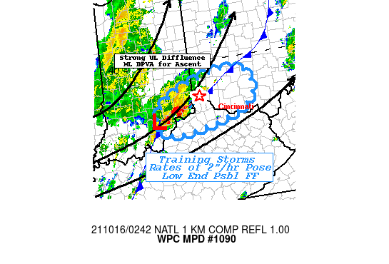
SUMMARY...Fast moving but training thunderstorms capable of
1.5-2"/hr rates and low-end flash flooding risk

DISCUSSION...02Z surface map shows a wave just north of Louisville
zipping north-northeast along a sharpening frontal zone through
the Cincinnati Metro area.   Maximized DPVA downstream of
approaching strong mid-level trof coincident with peak diffluent
pattern of the 110kt 3H jet streak provides ample upper level
support for further strengthening of the frontal zone and low
level moisture convergence along said boundary.  With nearly 180
degrees of convergence at the surface and upper 60s Tds with
modest 500-750 J/kg CAPE, thunderstorms have been strengthening
but also expanding downstream (Hamilton county, OH) of the
main/strongest cluster in Scott to Jefferson county IND.  Recent
observations of 1.85" in an hour and 2" in about 1.5 hours near
Salem denote the deep unidirectional steering flow parallel to the
front ahead of the surface wave is sufficient for low-end
exceedance of 1hr FFG values in the region particularly along/near
the bluffs of the Central Ohio River and urban center.

While deep layer flow is parallel, it is very stronger limiting
duration to about 1-2 hours and so the areal coverage of potential
flash flooding is going to be a narrow track potentially through
the urban location of Metro Cincinnati increasing higher run-off
given rates of 2"/hr for possible short-duration flash flooding.

Gallina

ATTN...WFO...ILN...IND...LMK...

ATTN...RFC...OHRFC...NWC...

LAT...LON   39708392 39668319 39258295 38838322 38548406
            38338524 38428585 38858593 39228552 39538471
Last Updated: 1046 PM EDT Fri Oct 15 2021
|


