| WPC Met Watch |
|
|
Mesoscale Precipitation Discussion: #1055 (2018) |
|
(Issued at 515 AM EST Mon Dec 17 2018
) |
|
| MPD Selection |
|
|
|
|
|

Mesoscale Precipitation Discussion 1055
NWS Weather Prediction Center College Park MD
515 AM EST Mon Dec 17 2018

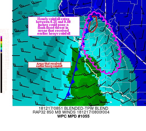
Areas affected...Central California

Concerning...Heavy rainfall...Flash flooding possible

Valid 171015Z - 171515Z

Summary...Deep moisture funneled ahead a cold front could pose a
localized flash flood threat this morning in areas that received
heavy rainfall earlier.

Discussion...Regional radars showed a weakening axis of heavy
rainfall extending from the central Sierra Nevada Range to the
central CA coast. The axis of heaviest rainfall is coincident with
a deep moisture plume (the most recent blended TPW product showed
1.00 inch precipitable water air in the plume) associated with a
weakening atmospheric river. A 20 to 30 knot low level southwest
flow (per regional VWP) is steering the moisture into the higher
terrain from the central Sierra Nevada Range to the central CA
Coastal Range. Surface observations and the most recent MRMS one
hour precipitation product indicated hourly rainfall rates
generally under 0.25 inches.

However, as the front crosses the central CA coast this morning,
the low level flow increases ahead of an approaching long wave
trough, perhaps pushing hourly rainfall rates to between 0.25 and
0.50 inches (which is supported by the most recent HRRR). Regional
radars are showing a blossoming area of heavy rainfall near
Marysville, and surface observations showed hourly rainfall rates
near 0.40 inches at Watsonville.

Local radars and surface observations indicate that between 1.50
and 2.00 inches of rainfall occurred in this area during the past
12 hours. The additional heavy rainfall (which could approach an
inch locally, per the most recent HRRR) may result in a threat for
localized mudslides and debris flows.

Outside of this area, the threat for flash flooding appear to be
somewhat limited outside of training, and progressive nature of
the system. However, heavy rainfall could result localized
flooding issues.

Hayes

ATTN...WFO...HNX...LOX...MTR...REV...STO...

ATTN...RFC...CNRFC...

LAT...LON   39962089 39892068 39782057 39692048 39211997
            38941972 38361937 37391886 36511877 35851901
            35591949 35732035 35812046 36282106 37312194
            38462195 39082172 39592153 39902125
Last Updated: 513 AM EST Mon Dec 17 2018
|


