| WPC Met Watch |
|
|
Mesoscale Precipitation Discussion: #0965 (2018) |
|
(Issued at 507 AM EDT Thu Oct 11 2018
) |
|
| MPD Selection |
|
|
|
|
|

Mesoscale Precipitation Discussion 0965
NWS Weather Prediction Center College Park MD
507 AM EDT Thu Oct 11 2018

Areas affected...Southeast U.S.

Concerning...Heavy rainfall...Flash flooding likely

Valid 110906Z - 111500Z

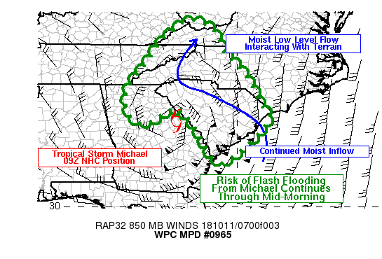
Summary...The core rain bands associated with Tropical Storm
Michael will continue to bring heavy to excessive rainfall over
parts of Georgia and the Carolinas through mid-morning.  The most
intense rainfall rates will continue to be near the storm center
but the influx of moisture encountering the terrain of the
southern Appalachians will also be aiding the risk of excessive
rainfall.

Discussion...Latest radar imagery shows the center of Tropical
Storm Michael located over eastern Georgia early this morning. The
eyewall convection remains very intense with hourly rates
exceeding 1-2" with the spiraling rain bands showing hourly rates
as high as 1 inch well away from the center.

There is good consensus in the latest hi-res models that show
widespread averages of an additional 1-3" likely through 11 AM EDT
with locally higher amounts associated with the center of the
storm and along the east face of the Appalachians in the Carolinas
where the deep moisture encounters the complex terrain. The
approach of an upper trof and surface cold front from the west may
enhance rainfall rates in the area as well.

Bann

ATTN...WFO...CAE...CHS...FFC...GSP...ILM...JKL...MRX...RAH...
RLX...RNK...

ATTN...RFC...LMRFC...OHRFC...SERFC...

LAT...LON   37608190 37228098 36278052 35417971 34097901
            33487877 31808065 33158164 34038247 33418376
            33918450 34898444 35818377 36688314 37158267
Last Updated: 507 AM EDT Thu Oct 11 2018
|


